


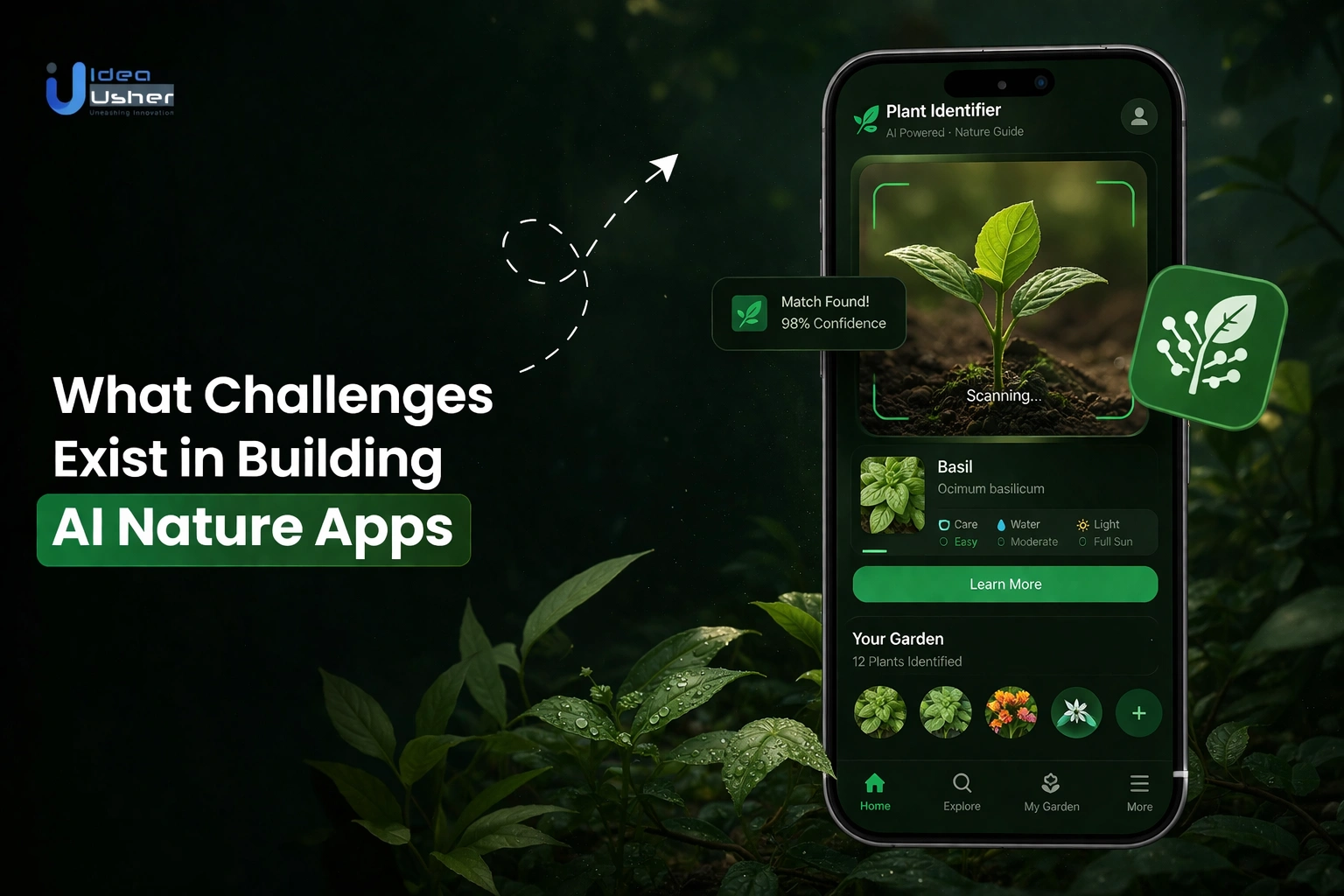
AI nature apps are expected to identify species, interpret images, and support outdoor exploration in environments that are often unpredictable. The lighting conditions, image quality, regional biodiversity, and incomplete datasets impact accuracy, highlighting AI nature app development challenges where reliability depends on handling real-world variability.
The complexity of working with real-world ecological data is compounded by the need for constant species database updates, user-generated content validation, and model predictions that balance accuracy with explainability. The effectiveness of these platforms depends on how well they manage uncertain data while maintaining performance, scalability, and user trust.
In this blog, we explore what challenges exist in building AI nature apps by examining data limitations, system constraints, and the practical considerations involved in developing reliable nature-focused AI applications.
Why AI Nature Apps Are Harder Than They Look?
The development of nature platforms exceeds standard recognition as a market projected to reach USD 1.23 billion by 2033 (14.7% CAGR) underscores digital research’s impact. AI nature app development challenges involve converting extreme outdoor variables like weather and movement into reliable, structured data.

A. From Hobby App To Scientific-Grade Platform
Moving from a simple identification tool to a platform that scientists can trust requires a shift in data architecture. A hobbyist tool identifies a plant for personal interest, but a scientific-grade platform must prove that the observation is a factual record of biodiversity.
| Feature | Hobbyist Identification | Scientific-Grade Platform |
| Data Goal | Personal curiosity | Peer-reviewed research data |
| Location Data | General city or region | Precise GPS coordinates |
| Validation | AI guess only | AI + Human expert consensus |
| Metadata | Basic photo date | Hardware specs, elevation, and climate |
To achieve this level of quality, the platform must enforce strict data standards. This ensures that every upload contributes to global conservation efforts rather than just filling a server with unverified images.
C. The Gap Between Demo AI And Real-World Accuracy
A common pitfall in AI nature app development challenges is relying on models trained in perfect conditions. Laboratory data uses clear, centered subjects, but real-world users often capture blurry or obscured photos.
- Environmental Noise: Foliage, shadows, and rain can confuse standard computer vision models.
- Look-Alike Species: Many plants and insects are visually identical to the untrained eye, requiring the AI to look for microscopic differences.
- Contextual Intelligence: Advanced systems do not rely on pixels alone. They use the user’s location and the current season to narrow down the most likely species.
- Macro Limitations: Identifying small organisms like fungi or insects requires high-resolution detail that standard smartphone cameras sometimes struggle to provide.
D. Why Apps Like iNaturalist Succeed Where Others Fail
Success in this space depends on the relationship between the technology and the community. If the AI is the only source of truth, the app remains a novelty. Platforms like iNaturalist thrive because they use technology to facilitate human interaction.
- The Feedback Loop: The AI provides a starting point, but a network of naturalists and scientists provides the final verification.
- Incentivized Participation: Users feel their contributions matter because their data is used in actual scientific publications and conservation projects.
- High Integrity Standards: Leading platforms prioritize accuracy over instant gratification. They are designed to admit uncertainty rather than providing a confident but wrong identification.
- Open Ecosystems: By sharing data with global biodiversity databases, these apps become indispensable to the scientific community, creating a self-sustaining cycle of growth and expert moderation.
Core Technical Challenges In AI Nature Apps
The development of nature platforms exceeds standard detection as identifying living organisms requires navigating vast evolutionary diversity. AI nature app development challenges center on creating systems that are both mathematically precise and operationally resilient against the unpredictable variables of the field.

A. Training AI On Diverse Species Datasets
The training of high-performance nature models requires massive datasets covering vast life cycles. Unlike general data, biological inputs suffer from high intra-class variation and deceptive similarities between distinct species.
- Morphological Variability: A single plant species may look entirely different depending on whether the user photographs the leaf, the flower, the bark, or the fruit.
- Life Stage Diversity: Models must recognize an insect in its larval, pupal, and adult stages, which often share no visual commonalities.
- Seasonality Impacts: Flora changes drastically across seasons; a tree in winter is visually unrecognizable compared to its summer state, requiring training data that spans the entire calendar year.
- Multi-View Requirements: To achieve scientific-grade accuracy, models often need to process multiple angles of a single specimen to confirm identifying characteristics that are not visible from a single “hero shot.”
B. Handling Rare And Underrepresented Species
A significant hurdle in AI nature app development challenges is the “long-tail” distribution of data. Common species like the House Sparrow have millions of training images available, while endangered or rare species may only have a handful of documented sightings.
- Few-Shot Learning: Training models to recognize new species using only 5–10 reference images.
- Synthetic Data: Using 3D modeling and generative AI to create biologically accurate training images for rare species.
- Taxonomic Prioritization: Programming AI to identify Genus or Family when a specific species match is statistically uncertain.
- Expert Crowdsourcing: Routing low-confidence images to human specialists to build a verified training set over time.
C. Balancing Model Accuracy Vs Response Speed
Users expect near-instant feedback in a field environment, yet high-precision biological identification is computationally expensive. Developers must decide where the heavy lifting happens on the user’s device or on a remote server.
- On-Device Inference: This allows for offline use in remote wilderness areas but limits the size and “intelligence” of the model due to mobile hardware constraints.
- Cloud-Based Processing: Offers access to massive neural networks with billions of parameters, ensuring higher accuracy at the cost of requiring a stable data connection.
- Quantization and Pruning: These technical optimizations shrink the model size to improve speed on mobile devices, though they often result in a slight dip in fine-grained identification accuracy.
- Tiered Feedback: Some systems provide an “instant guess” locally while the high-resolution image is uploaded for a more thorough, server-side analysis.
D. Scaling Image Recognition Across Environments
A model trained on North American flora often fails when deployed in a tropical rainforest. Scaling a nature app globally means the AI must account for the geographical context of every upload.
- Geospatial Filtering: By using GPS data, the app can “mask” species that are geographically impossible in the user’s current location, drastically reducing the margin for error.
- Climate Adaptation: AI must be tuned to recognize how the same species might vary in size or color based on local soil quality, humidity, and altitude.
- Hardware Agnostic Performance: The app must deliver consistent results across a range of hardware, from high-end flagship smartphones to budget devices with inferior lenses and sensors.
- Localized Metadata: Integration with regional biodiversity databases ensures that common names and conservation statuses are relevant to the user’s specific territory.
Data Challenges In Citizen Science Platforms
The success of a nature-based platform depends entirely on the integrity of user-provided data. Addressing AI nature app development challenges in this sector requires sophisticated filtering systems to transform casual crowdsourced contributions into valuable, actionable intelligence for the scientific community.
1. Ensuring Data Quality From User Submissions
High-quality wildlife research depends on specific visual evidence for independent verification. Without these standards, databases become cluttered with unusable imagery that drains server resources and complicates the entire identification process.
- Evidence-Based Requirements: Platforms must encourage or require “diagnostic” photos, such as shots of both the top and underside of a mushroom or the leaf arrangement of a plant.
- Automated Quality Scoring: Implementing AI that pre-screens images for focus, lighting, and subject framing before they are even submitted to the database.
- User Education Loops: Providing real-time feedback to users, explaining why a specific photo might be unidentifiable and how to improve their technique for future observations.
- Incentive Alignment: Creating a reputation system where users who consistently provide high-quality, verifiable data earn higher “trust” scores, which can prioritize their submissions for expert review.
2. Dealing With Mislabeled And Noisy Datasets
Human error is an inevitability in the world of citizen science. Users often misidentify species based on local myths or superficial similarities. If these errors are not caught, they “poison” the training set for future AI iterations, leading to a cycle of inaccuracy.
| Challenge | Impact on System | Mitigation Strategy |
| Common Misidentification | AI learns to repeat human errors. | Peer-review consensus where multiple experts must agree. |
| Ambiguous Subjects | Confusion between multiple organisms in one frame. | Multi-object detection to isolate the primary subject. |
| Malicious Submissions | Intentional spam or fake data points. | Anomaly detection algorithms to flag suspicious activity. |
| Out-of-Scope Data | Photos of pets or indoor plants. | AI filters that automatically reject non-wildlife subjects. |
3. Building Structured Biodiversity Databases
Data is only useful if it is organized in a way that researchers can query. Transforming a collection of photos into a structured database requires adhering to international biological standards while managing immense amounts of relational information.
- Taxonomic Mapping: Every entry must be linked to a dynamic taxonomic tree, ensuring that if a species is reclassified by scientists, the entire database updates accordingly.
- Relational Metadata: Storing observations in a way that connects species data with environmental variables like weather patterns, soil types, and local ecological zones.
- Interoperability: Utilizing the Darwin Core standard, a globally recognized set of terms for biodiversity informatics, to allow data sharing with international scientific bodies.
- Search Optimization: Building high-performance indices that allow scientists to filter millions of records by date range, location, and species family in seconds.
4. Managing Geotagging And Timestamp Reliability
The “where” and “when” of an observation are often more important to scientists than the “what.” However, GPS drift and incorrect device time settings can compromise the validity of a record.
- Coordinate Precision vs. Privacy: Implementing “geoprivacy” tools that allow scientists to see exact locations while blurring coordinates for the general public to protect endangered species from poachers.
- Hardware Verification: Cross-referencing phone GPS data with cell tower signals and Wi-Fi networks to ensure the location has not been spoofed or manually altered.
- Temporal Logic Checks: Running automated scripts to flag “impossible” observations, such as a tropical plant appearing in a snowy climate, which suggests a timestamp or location error.
- Offline Synchronization: Developing robust caching systems that accurately preserve the original capture time and location even when a user is miles away from cellular service.
Challenges In AI Model Performance In Nature
The unpredictability of the natural environment serves as a rigorous testing ground for computer vision. Unlike industrial AI, AI nature app development challenges center on achieving high confidence levels despite the chaotic, non-linear variables of diverse and uncontrolled ecological contexts.

A. Variability In Lighting, Angles & Backgrounds
A model that recognizes a species in a bright, clear photograph may fail entirely when that same species is shadowed, partially obscured, or set against a complex background. Overcoming these visual hurdles is essential for maintaining a high-utility user experience.
- Luminance Extremes: AI must be trained to normalize images taken in harsh midday sun, deep forest shade, or low-light dusk conditions.
- Occlusion Handling: In the wild, animals are often partially hidden by tall grass or branches; the system needs to identify the “whole” from fragmented visual cues.
- Background Complexity: Camouflage is a biological survival strategy that acts as a direct counter-measure to image recognition. Models must distinguish between a cryptic insect and the bark it is resting upon.
- Perspective Distortions: Users capture images from varying heights and angles. A top-down view of a flower looks radically different from a side-profile view, necessitating a training set that includes a 360-degree morphological understanding.
B. Seasonal And Regional Species Variations
Biological organisms are not static; they change their physical appearance based on their lifecycle and their environment. A static AI model quickly becomes obsolete if it cannot account for the fluidity of nature.
| Variable | Impact on AI Recognition | Technical Solution |
| Phenology | Plants change from budding to flowering to fruiting stages. | Training sets categorized by month and growth stage. |
| Sexual Dimorphism | Males and females of the same species often look entirely different. | Tagging datasets with gender-specific labels to improve precision. |
| Regional Morphs | The same bird species may have different plumage colors in different latitudes. | Regional “weights” that prioritize local subspecies in the neural network. |
| Pelage Change | Mammals grow thick, pale coats in winter and thin, dark coats in summer. | Temporal data integration to adjust expectations based on the date. |
C. Continuous Learning & Model Retraining Cycles
New biodiversity data is generated every second; thus, a rigid model fails. Addressing AI nature app development challenges requires a CI/CD pipeline where human-verified observations constantly refine the training loop.
- Active Learning: The system identifies “high-uncertainty” images and prioritizes them for expert human review to bridge its own knowledge gaps.
- Version Control for Species: As taxonomy changes or new species are discovered, the model must be retrained without losing its previous accuracy on existing species.
- Dataset Balancing: Constantly adjusting the training mix to ensure that common species do not “drown out” the signals of rarer organisms during the learning process.
- Automated Validation: Running new model versions against a “golden set” of verified images to ensure that improving one species’ recognition doesn’t accidentally degrade the accuracy of another.
D. Edge Cases Where AI Fails Human-Level Accuracy
There are specific scenarios where human intuition and expert knowledge still outperform silicon despite advances in deep learning. Recognizing these limitations is a critical part of managing AI nature app development challenges.
- Micro-Characteristics: Some species can only be distinguished by the texture of their underside or the specific vein pattern in a wing, details often lost in standard mobile photography.
- Olfactory and Tactile Data: Expert naturalists often use smell or touch (e.g., the stickiness of a mushroom cap) to identify a species, data points that current AI cannot yet process.
- Behavioral Context: A human can identify a bird by its flight pattern or its song, while a vision-only AI is limited strictly to the still pixels of a photo.
- Hybridization: Natural hybrids between two closely related species can create “intermediate” appearances that fall outside the defined boundaries of a model’s training categories.
UX Challenges In AI-Powered Nature Apps
The success of a nature-centric platform depends on bridging the gap between scientific data and hiker curiosity. Addressing AI nature app development challenges requires designing accessible yet authoritative interfaces that facilitate rapid, one-handed data entry in harsh outdoor conditions without compromising professional-grade technical detail.
1. Designing For Both Beginners & Experts
A platform that caters only to scientists will struggle to scale, while an app that is too simplistic will lose its credibility in the research community. The interface must provide a “tiered” experience that grows with the user’s knowledge level.
- Progressive Disclosure: Hide advanced technical fields (like subspecies taxonomy or phenology tags) behind an “Advanced” toggle to avoid overwhelming new users.
- Onboarding via Curiosity: Use the AI to immediately reward beginners with a name and a fun fact, while providing experts with the raw metadata and confidence scores they require.
- Mentorship Features: Create UX elements that allow experts to easily comment on or correct beginner observations, fostering a community-driven learning environment.
- Dual-Mode Interfaces: Allow users to switch between a “Quick Capture” mode for casual hiking and a “Survey” mode for systematic ecological mapping.
2. Simplifying Complex Ecological Data
Nature apps generate an immense amount of information, from conservation status and population trends to blooming schedules and migratory patterns. Presenting this data in a digestible format is critical for user retention.
- Taxonomy: Prioritize common names while including complex Latin hierarchies in a smaller, secondary font to maintain scientific accuracy without overwhelming users.
- Seasonality: Replace dense activity charts with simple, color-coded heatmaps or intuitive “Best Time to See” icons for quick reference.
- Distribution: Manage large GPS datasets through interactive maps with dynamic clusters that expand as the user zooms in for more detail.
- Conservation Status: Simplify technical codes like LC, VU, or EN by using visual badges with clear labels such as “Least Concern” or “Endangered.”
3. Creating Intuitive Species Identification Flows
The core utility of the app, the identification process, must be frictionless. If a user has to navigate through five menus to identify a flower, they will likely stop using the tool.
- Real-Time Viewfinder Suggestions: Implement AR-style overlays that provide “live” guesses as the user points their camera at a subject, rather than making them wait for a post-upload analysis.
- Visual Search Filters: If the AI is unsure, provide the user with a “triage” system asking simple questions like “What color were the petals?” or “Was the leaf serrated?” to narrow down results.
- Confidence Visualizations: Use clear indicators (like a percentage bar or star rating) to show how sure the AI is, helping the user understand when a human expert’s opinion might be needed.
- Comparison Tools: Display the user’s photo side-by-side with a verified reference image to help them visually confirm the AI’s suggestion.
4. Reducing Friction In Observation Uploads
The biggest hurdle is the “drop-off” during the upload phase in many AI nature app development challenges. Field conditions are rarely ideal for data entry, so the app must automate as much as possible.
- Smart Metadata Autofill: Automatically extract date, time, and location from the image’s EXIF data so the user doesn’t have to type it manually.
- Offline Queuing: Ensure the app can “save” observations locally when there is no cell service and automatically sync them once the user returns to a network.
- Batch Uploading: Allow users to take twenty photos of twenty different plants and process them all at once at the end of their hike, rather than forcing a one-by-one workflow.
- One-Tap Verification: For common species, allow a “Confirm and Save” button that requires only a single tap, significantly speeding up the documentation of high-frequency sightings.
Building A Crowdsourced Validation System
A self-sustaining nature platform relies on a “trust economy” where communities verify their own data. Navigating AI nature app development challenges in this area involves building a social architecture that rewards precision, ensuring the database remains a reliable “living record.”

1. Designing Trust-Based Community Verification
Verification is not a binary “correct or incorrect” process; it is a cumulative consensus. A robust system requires multiple independent data points before an observation can be promoted to a higher status, such as “Research Grade.”
- Consensus Algorithms: Implementing a rule where at least two out of three independent identifiers must agree on a species before the label is considered “locked.”
- Reputation Weighting: Not all votes are equal. An identification from a verified botanist or a user with 10,000 successful IDs should carry more weight than a first-time user.
- Conflict Resolution UI: When two experts disagree, the system must provide a dedicated space for discussion, allowing users to upload additional photos or “diagnostic” descriptions to settle the debate.
- Taxonomic Disagreement Handling: If the community agrees on the Genus but disagrees on the Species, the system should automatically “roll back” the identification to the nearest certain taxonomic level.
2. Preventing Spam And False Observations
It inevitably attracts “noise” as a platform grows, ranging from accidental pet photos to intentional data spoofing. Protecting the integrity of the biodiversity record is a constant battle in AI nature app development challenges.
| Risk Type | Impact | Prevention Strategy |
| Non-Wild Subjects | Clutters database with dogs, cats, and houseplants. | AI pre-filters that flag “Captive/Cultivated” subjects for user review. |
| Location Spoofing | Ruins migration and distribution maps. | Cross-referencing EXIF GPS data with hardware-level location pings. |
| Duplicate Spam | Artificially inflates species counts. | Image hashing technology to detect and merge identical photo uploads. |
| Automated Bots | Floods the platform with fake data. | Rate-limiting uploads and requiring CAPTCHA for high-frequency accounts. |
3. Incentivizing Expert Participation
The most valuable users such as professional scientists and veteran naturalists are often the busiest. To keep them engaged, the platform must offer value that goes beyond simple “likes” or social badges.
- Data Export Tools: Provide experts with powerful API access and CSV export tools so they can use the platform’s data for their own professional research.
- Academic Attribution: Ensure that when an expert’s identification leads to a scientific discovery, their username is cited in the resulting publication or dataset.
- Curated Notifications: Allow experts to subscribe to specific “interest zones,” such as “All rare orchids in the Pacific Northwest,” so they only spend time on observations they care about.
- Leadership Roles: Creating a “Moderator” or “Curator” tier that grants trusted users the ability to merge duplicate species pages or correct systemic taxonomic errors.
4. Moderation At Scale With AI + Human Review
Scaling to millions of observations per month makes purely manual moderation impossible. A hybrid approach is necessary, where AI acts as the “first responder” and humans act as the “supreme court.”
- Automated Triage: AI scans all incoming photos. High-confidence matches for common species are processed quickly, while “low-confidence” or “rare” sightings are moved to the top of the human expert’s queue.
- Anomaly Detection: Machine learning models flag observations that appear in the “wrong” place (e.g., a desert cactus in a rainforest), triggering an immediate request for human verification.
- Community Flagging: Empowering the general user base to “Flag for Review” any suspicious content, which then enters a prioritized moderation workflow.
- Iterative Training: Every time a human moderator corrects an AI mistake, that data point is “flagged” to be included in the next model training cycle, ensuring the system learns from its failures.
Infrastructure Challenges At Scale
Operating a global biodiversity platform requires a backend for massive high-resolution media. Solving AI nature app development challenges at this scale involves moving beyond basic setups toward a highly distributed, elastic infrastructure that handles unpredictable surges in global traffic as users grow.
1. Handling Millions Of Image Uploads Daily
Massive data volumes can overwhelm standard pipelines at global scale. During seasonal peaks, systems must scale horizontally without manual intervention to handle dramatic upload spikes and ensure consistent performance.
- Asynchronous Ingestion: Utilizing message queues to decouple the upload process from the processing phase. This ensures that a user receives a “Success” message immediately while the heavy AI analysis happens in the background.
- Auto-Scaling Compute Clusters: Implementing container orchestration that automatically spins up new instances as the upload queue grows, ensuring that processing times remain consistent regardless of load.
- Edge Ingestion Points: Deploying entry points closer to the user to reduce the time it takes for a high-resolution image to travel from a remote forest to the central database.
- Validation at the Edge: Performing basic file integrity and “Is this a photo?” checks at the point of entry to prevent junk data from ever reaching the core processing engine.
2. Real-Time Processing With Cloud Architecture
Users expect an immediate identification, but a deep-learning model requires significant computational power. Designing a cloud architecture that balances this need for speed with the cost of high-performance GPUs is a constant optimization task.
- GPU Inference Engines: These run the computer vision models, using request batching to maximize GPU utilization and minimize idle time.
- Serverless Functions: These handle metadata extraction and logging by triggering small, isolated code snippets only when a new file is uploaded.
- In-Memory Caching: This involves using Redis to store frequent search results and species data, providing sub-millisecond access to common taxonomic information.
- Load Balancers: These distribute traffic across multiple regions, directing users to the nearest available compute node to minimize latency.
3. Storage Optimization For Biodiversity Data
Storing hundreds of millions of high-resolution images is prohibitively expensive if not managed correctly. A strategic approach to storage tiering ensures that the platform remains financially sustainable while keeping data accessible for researchers.
- Multi-Tiered Storage: Keeping “active” observations on high-speed SSDs while moving older or unverified data to “Cold Storage” (like Amazon S3 Glacier) to significantly reduce monthly costs.
- Image Pyramiding: Storing multiple versions of a single upload—a thumbnail for the feed, a medium-res version for the app, and the original “Raw” file for scientific analysis.
- Content Delivery Networks (CDNs): Using a global CDN to cache images geographically, so a user in Tokyo doesn’t have to fetch an image from a server in London.
- Deduplication Engines: Scanning for identical uploads or “burst” shots from the same user to avoid storing redundant data that adds no scientific value.
4. Managing Global User Traffic And Latency
Nature apps are used everywhere, from dense urban parks to the most remote corners of the planet. Managing latency for a global audience requires a decentralized approach to data management.
- Global Database Replication: Implementing a “Write Anywhere, Read Everywhere” database architecture to ensure that a user’s profile and observation history are available instantly, regardless of where they log in.
- Latency-Based Routing: Automatically directing app traffic to the data center with the lowest ping, improving the perceived speed of the “Identify” button.
- Progressive Image Loading: Utilizing “Blur-up” techniques where a tiny, low-quality version of an image loads instantly while the high-resolution version fetches in the background.
- Offline-First Sync Logic: Developing robust conflict-resolution protocols for when a user uploads 50 observations at once after being offline for a week, ensuring the timeline and geotags remain perfectly synchronized.
Geolocation & Mapping Complexity
The precision of location data is fundamental for biological research. Addressing AI nature app development challenges requires integrating mapping systems that balance technical accuracy and hardware limitations with the sensitive need to protect exact coordinates for rare or endangered species.

1. Accurate GPS Tagging In Remote Areas
Reliable geotagging is difficult in the very places where nature apps are most useful like deep forests, canyons, and remote mountains. “GPS drift” can misplace an observation by hundreds of meters, which can lead to incorrect habitat mapping.
- Multi-Constellation Support: Modern platforms must tap into multiple satellite systems, including GPS, GLONASS, and Galileo, to increase coordinate accuracy under heavy tree canopy.
- Sensor Fusion: Utilizing the phone’s accelerometer and compass to “dead reckon” a position when the satellite signal is momentarily lost.
- Horizontal Accuracy Metadata: Storing the “accuracy radius” (e.g., +/- 10 meters) alongside the coordinates so researchers know the margin of error for that specific data point.
- Manual Correction Tools: Providing a UX that allows users to manually refine their location on a map if they know the auto-tag is slightly off due to signal interference.
2. Integrating GIS And Mapping Systems
The backend must integrate with Geographic Information Systems (GIS) to turn a list of coordinates into a professional tool. This allows the app to understand not just where a user is, but the ecological context of that location.
| Mapping Layer | Purpose in Nature Apps | Technical Implementation |
| Topographic Layers | Understanding elevation and slope. | Integration with USGS or Digital Elevation Models (DEM). |
| Ecoregion Masking | Identifying local biomes. | Overlaying specialized polygons from the World Wildlife Fund (WWF). |
| Climate Data | Correlating sightings with weather. | Real-time API hooks into global meteorological databases. |
| Protected Area Borders | Highlighting National Park data. | Syncing with the World Database on Protected Areas (WDPA). |
3. Privacy Concerns With Location Sharing
Transparency is a core tenet of citizen science, yet it risks wildlife safety. Openly sharing rare species’ locations can inadvertently provide roadmaps for poachers or tourists, threatening endangered habitats.
- Coordinate Obfuscation: Automatically “blurring” the exact coordinates of threatened species by showing a generalized 10-kilometer box instead of a pin.
- Private Observations: Giving users the option to keep a location completely hidden from the public while still allowing verified scientists to see the raw data for research.
- Geofencing Sensitive Zones: Identifying “hotspots” of biodiversity where the app automatically increases privacy settings for all uploads within that boundary.
- User Anonymization: Decoupling the user’s identity from the location data in public exports to prevent “tracking” a user’s movements through their nature hikes.
4. Visualizing Large-Scale Biodiversity Data
Presenting millions of data points on a mobile screen without crashing the app or confusing the user is a significant engineering feat. Effective visualization transforms raw numbers into a narrative of ecological health.
- Dynamic Heatmaps: Using color density to show species “hotspots” that update in real-time as the user pans across different geographic regions.
- Clustering Algorithms: Grouping thousands of nearby pins into a single “cluster” icon that expands only when the user zooms in, preserving both clarity and device performance.
- Temporal Animation: Allowing users to “play” a timeline of sightings to see how a species migrates or how a bloom moves across a continent over several months.
- Filtering by Taxonomy: Building high-speed spatial indices that allow a user to instantly see “Every sighting of a Monarch Butterfly within 50 miles” without loading the entire global database.
Regulatory And Ethical Challenges
The intersection of biodiversity and digital technology introduces a complex layer of responsibility beyond code. Navigating AI nature app development challenges requires a proactive stance on data governance, ensuring that platforms prioritize ecological safety so these tools don’t inadvertently harm the environment.
1. Protecting Sensitive Species Location Data
The most significant ethical risk in nature app development is the “poacher’s map” effect. Openly sharing the precise coordinates of a rare orchid, a nesting site, or a high-value timber tree can lead to the physical destruction of the subject.
- Automated Redaction: Implementing a system that automatically recognizes species on the IUCN Red List of Threatened Species and “obscures” the location by several kilometers in public views.
- Access Tiers: Creating a “vetted researcher” status where only verified conservationists and academic professionals can request access to the true high-resolution coordinates.
- Temporal Masking: Delaying the public release of a sighting by weeks or months for certain species to ensure the animal has moved on before the location is made public.
- Metadata Scrubbing: Stripping the original EXIF data from shared images so that tech-savvy users cannot extract hidden GPS tags from the raw file.
2. Compliance With Global Data Privacy Laws
The platform still collects vast amounts of Personal Identifiable Information (PII) from its human contributors while the focus is often on the species. Operating globally means adhering to a patchwork of stringent legal frameworks.
| Regulation | Impact on App Development | Required Action |
| GDPR (Europe) | Strict rules on user data portability and the “Right to be Forgotten.” | Implementing easy-to-use data deletion and export tools for all EU users. |
| CCPA (California) | High transparency requirements for how user data is shared or sold. | Providing clear, non-legalese privacy notices regarding data usage. |
| COPPA (USA) | Protection for users under 13, common in educational nature apps. | Building specialized “Junior” accounts that disable location sharing and social features. |
| Local Biodiversity Laws | Some nations restrict the export of “biological data” across borders. | Ensuring server architecture allows for regional data residency where legally required. |
3. Ethical AI Use In Environmental Research
AI models are not neutral; they are reflections of their training data. In environmental research, an “unbalanced” AI can lead to skewed scientific conclusions that affect funding and conservation policy.
- Algorithmic Bias Mitigation: Actively auditing models to ensure they don’t over-represent common “charismatic megafauna” (like bears or eagles) while ignoring critical but “unattractive” species like fungi or soil insects.
- Transparency in Confidence: Labeling AI-generated identifications as “Machine Predicted” to prevent them from being mistaken for peer-reviewed facts in scientific journals.
- Open Source Ethics: Encouraging the sharing of model weights and training methodologies so the scientific community can peer-review the “logic” behind the AI’s identifications.
- Non-Invasive Documentation: Designing UX prompts that remind users to keep a safe distance from wildlife and avoid trampling sensitive habitats just to get a “better photo” for the AI.
4. Preventing Misuse Of Ecological Data
Beyond poaching, ecological data can be misused for unauthorized commercial harvesting or by land developers looking to “clear” a site before a rare species is officially documented.
- Usage Agreements: Requiring anyone downloading large datasets to sign a legally binding “Terms of Use” that prohibits commercial exploitation or harmful land-use applications.
- Anomaly Detection in Downloads: Using AI to monitor for suspicious data-scraping patterns, such as an account downloading all locations for a specific high-value medicinal plant.
- Strategic Data “Noise”: In some cases, introducing a slight, controlled “jitter” to public data exports to prevent the triangulation of exact habitat boundaries by unauthorized parties.
- Institutional Oversight: Partnering with established NGOs and government environmental agencies to provide an external ethical audit of the platform’s data-sharing policies.
Engagement And Retention Challenges
The long-term viability of a nature-centric platform depends on a consistent stream of high-quality data. Addressing AI nature app development challenges involves converting casual observers into dedicated citizen scientists through psychological design that moves beyond simple identification toward environmental stewardship.

1. Turning Users Into Active Contributors
The transition from a passive consumer to an active contributor is the most difficult stage of the user journey. Most users are satisfied once they know the name of a plant; the challenge is convincing them to document it properly for the benefit of the global community.
- Lowering the Barrier to Entry: Using AI to prepopulate as many fields as possible, so the user only needs to click “Submit” to contribute to a scientific database.
- Immediate Value Feedback: Showing the user exactly how their specific observation helps, for example, a pop-up stating, “Your photo helped map this species in a new county.”
- Localized Challenges: Creating “BioBlitz” events where users are encouraged to find as many species as possible in their local park within a 24-hour window.
- Social Validation: Implementing a notification system that alerts a user when a scientist or expert “agrees” with their identification, providing a hit of professional validation.
2. Gamification Vs Scientific Integrity Balance
Gamification is a powerful tool for retention, but if implemented incorrectly, it can incentivize bad data. If users are rewarded solely for the quantity of uploads, they may submit blurry photos or common garden plants just to level up.
| Gamification Element | Risk to Scientific Integrity | Solution for Integrity |
| Leaderboards | Encourages “spamming” low-quality IDs. | Score based on “Research Grade” confirmations, not raw uploads. |
| Badges & Achievements | May lead users to disturb wildlife for a “rare” badge. | Award badges for “Quality Data” and “Expert Helpful Comments.” |
| Streak Counters | Users might upload old photos or “fakes” to keep a streak. | Require unique GPS and timestamp verification for streak points. |
| Leveling Systems | High-level users might become “gatekeepers.” | Tiered levels that grant more responsibility (like voting) rather than just status. |
3. Building Long-Term Community Engagement
A platform is only as strong as the social bonds between its users. To move beyond a utility app, the UX must facilitate meaningful interaction between amateurs, hobbyists, and professionals.
- Interest-Based Sub-Groups: Allowing users to join “Niche Communities,” such as a group dedicated specifically to urban dragonflies or high-altitude lichens.
- Forum-Style Discussions: Moving beyond simple “Agree/Disagree” buttons to allow for detailed threads where users can share tips on photography or habitat tracking.
- Mentorship Programs: Automatically pairing new users with high-ranking “Guides” in their geographic area to help them improve their identification skills.
- Offline Integration: Partnering with local museums, botanical gardens, and hiking clubs to host “In-Real-Life” meetups that center around the app’s digital ecosystem.
4. Retaining Users Beyond Initial Curiosity
Many nature apps suffer from high “churn” rates once the novelty of the AI wears off. To keep users coming back year after year, the app must become a personal journal of their relationship with the outdoors.
- Personal Life-Lists: Creating a “Digital Life List” that automatically categorizes every unique species a user has ever found, similar to a birder’s checklist.
- Seasonal Recaps: Sending users an “Annual Nature Report” showing how their observations changed with the seasons and which rare species they encountered.
- Phenology Tracking: Allowing users to follow a specific “Patch” of land and receive alerts when the flowers they documented last year are about to bloom again.
- Predictive Discovery: Using AI to suggest “What to look for today,” based on the user’s location, the current weather, and what other people are finding in the area.
Monetization Challenges In Nature Apps
The generation of sustainable revenue for nature platforms is complex because biodiversity data is viewed as a public good. Overcoming AI nature app development challenges in monetization requires hybrid models that align financial incentives with scientific missions and ecological health.
1. Limited Direct Revenue Models
Unlike consumer apps that rely on high-frequency transactions or impulse buys, nature apps often have a seasonal and utility-based usage pattern. Finding a consistent revenue stream requires looking beyond the individual user toward B2B and institutional value.
- B2B Environmental Data Licensing: Providing high-resolution, verified biodiversity datasets to energy companies, real estate developers, and urban planners who require them for mandatory Environmental Impact Assessments (EIAs).
- Digital MRV (Measurement, Reporting, and Verification): Acting as the verification layer for the burgeoning carbon and biodiversity credit markets, charging fees to facilitate the audit of “nature-positive” land claims.
- Corporate CSR Platforms: Selling “white-label” versions of the app to large enterprises for employee engagement challenges, creating a recurring SaaS (Software as a Service) revenue stream.
- White-Label Educational Tools: Licensing specialized versions of the platform to schools, botanical gardens, and museums for use in their internal educational curricula.
2. Balancing Profit With Conservation Goals
Every monetization decision must be weighed against its potential impact on the natural world. If the pursuit of profit leads to the exposure of sensitive habitats or the exclusion of low-income citizen scientists, the platform’s core mission is compromised.
- Data Selling: While commercial exploiters may use data to harvest rare species, this risk is managed through strict vetting of data buyers and the obfuscation of sensitive location coordinates.
- In-App Advertising: To avoid tracking users or disrupting the “immersion in nature” experience, platforms can use non-intrusive, contextually relevant sponsorships instead of traditional ad networks.
- Aggressive Paywalls: These can reduce the volume of scientifically valuable data; therefore, basic identification and data submission should remain free to ensure a massive influx of observations.
- Exclusive Features: To prevent a “pay-to-play” barrier for scientific discovery, platforms must ensure all research-grade data remains open-access for non-profit academic use.
3. Exploring Partnerships And Grants
For many leading platforms, revenue is not a single stream but a tapestry of institutional support. Aligning with organizations that have a vested interest in biodiversity can provide the foundational funding needed to scale technical infrastructure.
- Academic Research Grants: Partnering with universities on specific studies (e.g., tracking the impact of climate change on bird migration) to secure government or foundation funding for data collection.
- NGO Strategic Alliances: Integrating with major organizations like National Geographic or the WWF, which can provide both scientific credibility and a pipeline of high-intent users.
- Governmental Contracts: Developing specialized modules for municipal governments to help them track invasive species or manage urban “green corridors.”
- Philanthropic Endowments: Establishing a non-profit arm that can accept tax-deductible donations from users who want to support the platform’s mission without receiving a direct product in return.
4. Premium Features Vs Open Science Access
The “Freemium” model is a standard in app development, but in the world of open science, it must be handled with precision. The goal is to charge for “convenience and depth” while keeping the “contribution and community” aspects free for everyone.
- Advanced Professional Tools: Charging a subscription for features like high-resolution offline mapping, advanced data visualization filters, and bulk-export capabilities for professional researchers.
- Private Project Workspaces: Allowing NGOs or private land owners to pay for “locked” projects where their data remains private and invisible to the general public.
- AI-Powered “Power Features”: Using a usage-based or “token” model for computationally expensive features, such as high-precision video identification or automated macro-photography enhancement.
- The “Contributor-First” Model: Offering premium status or badges as a reward for users who contribute high volumes of verified data, rather than just those who pay a monthly fee, ensuring the most valuable users stay engaged.
Security Challenges In Open Data Platforms
The maintenance of open-access biodiversity databases creates unique vulnerabilities. Addressing AI nature app development challenges in security requires protecting scientific integrity while ensuring infrastructure remains resilient against risks ranging from coordinated misinformation to technical exploitation, balancing public good with robust data safety.
1. Preventing Data Manipulation And Fraud
In a system where data drives policy, “fake” observations have real-world consequences. Whether hiding species for development or spoofing locations for contests, platforms must detect and neutralize all fraudulent inputs.
- Heuristic Pattern Matching: Using AI to identify “impossible” travel speeds such as a user uploading observations from three different continents within an hour.
- Image Metadata Forensics: Automatically scanning EXIF data for signs of manipulation, such as edited timestamps or coordinates that do not match the image’s lighting and weather conditions.
- Cryptographic Hashing: Assigning a unique digital fingerprint to every upload at the moment of capture, ensuring the file hasn’t been altered between the phone and the server.
- Peer-Review Auditing: Flagging sudden spikes in “Research Grade” approvals from new or suspicious accounts, which could indicate a coordinated effort to validate false data.
2. Securing APIs And Third-Party Integrations
Most successful nature platforms act as a hub for researchers, NGOs, and other apps. However, every external connection is a potential “backdoor” into the core database that must be rigorously managed.
- Public Research APIs: These face the risk of mass scraping that can crash servers, which is mitigated by implementing strict rate-limiting and regular API key rotation.
- Social Media Sharing: To prevent the accidental leaking of private GPS data, the system must strip all sensitive metadata before images are pushed to third-party feeds.
- GIS Mapping Tools: Protection against unauthorized access to “blurred” coordinates is maintained through the use of end-to-end encryption for all spatial data transfers.
- Partner Webhooks: These are vulnerable to data injection or “Man-in-the-Middle” attacks, requiring the use of TLS 1.3 for all outgoing and incoming data pings.
3. Protecting User-Generated Content
A nature app’s most valuable asset is its library of user-submitted media. Protecting this content involves not just preventing theft, but ensuring that the “digital rights” of the contributor are respected and that the files remain uncorrupted.
- Granular Permission Sets: Giving users “one-click” control over who can see their photos, ranging from “Fully Public” to “Vetted Scientists Only” or “Completely Private.”
- Watermarking and Attribution: Automatically embedding non-intrusive metadata or visible watermarks that credit the original photographer when images are shared externally.
- Secure Storage Redundancy: Utilizing distributed cloud storage with “Write Once, Read Many” (WORM) policies to prevent accidental or malicious deletion of historic records.
- Content Sanitization: Running all user-submitted files through a sandbox to strip out malicious scripts or “steganographic” payloads that could be hidden within image pixels.
4. Safeguarding Scientific Datasets
Once an observation is verified, it becomes part of a permanent scientific record. If this dataset is compromised, years of ecological research could be invalidated. Protecting these “Master Sets” is a matter of institutional security.
- Immutable Ledgering: Utilizing blockchain or append-only databases for the “final” versions of research-grade data, making it impossible to alter an observation retroactively without an audit trail.
- Air-Gapped Backups: Keeping offline copies of the core biodiversity database in secure, geographically separate locations to ensure recovery in the event of a catastrophic regional server failure.
- Role-Based Access Control (RBAC): Restricting “Edit” or “Delete” permissions to a very small group of verified administrators, with every action logged and monitored in real-time.
- Vulnerability Disclosure Programs: Engaging with the “white-hat” hacking community to find and patch security flaws in the open-source components of the platform before they can be exploited.
Case Study: Lessons From iNaturalist Model
The iNaturalist platform serves as the gold standard for blending AI with community. Solving AI nature app development challenges involves a “human-in-the-loop” architecture, proving that nonprofit initiatives can achieve technical sophistication and scale typically reserved for high-growth Silicon Valley startups.
A. How AI + Community Improves Accuracy
The platform does not treat AI as a final authority; instead, it uses a tiered identification system that creates a “virtuous cycle” of data refinement. This hybrid approach solves the accuracy gap that many solo-AI apps face.
- The AI Suggestion Engine: When a user uploads a photo, the computer vision model provides a list of “visually similar” species. This narrows the field from millions of possibilities to a manageable handful.
- Expert Crowdsourcing: Once a suggestion is made, the observation is pushed to a public feed where thousands of expert naturalists and hobbyists can confirm or correct the ID.
- The “Research Grade” Milestone: An observation only reaches peak scientific value once a 2/3 community consensus is reached. This removes the “AI hallucination” risk where a model might confidently misidentify a plant.
- Continuous Feedback Loops: Every human-verified observation is eventually fed back into the next training iteration of the AI, making the model progressively smarter and more attuned to regional variations.
B. Scaling Citizen Science Globally
Scaling a nature app requires more than just server capacity; it requires cultural and linguistic localization. iNaturalist successfully expanded by decentralizing its authority through the “iNaturalist Network.”
- Regional Nodes: To encourage localized ownership of data, the platform partners with local NGOs (e.g., iNaturalist Canada, iNaturalist India) to manage regional communities.
- Multilingual Support: This strategy removes barriers to entry by translating common names and UI elements into dozens of local languages.
- Global Biodiversity Sync: To ensure institutional relevance, the system automatically pushes “Research Grade” data to the GBIF, making the app indispensable to global scientists.
- Low-Bandwidth Optimization: This improves accessibility in developing nations by allowing offline captures that sync only when a stable connection is found.
C. Key Product Decisions That Drove Growth
Success was driven by a few critical design and philosophical choices that prioritized long-term utility over short-term engagement metrics. These decisions helped the platform avoid the “novelty trap.”
| Strategy | Impact on Growth | Implementation Detail |
| Open Data Philosophy | Attracted the scientific community for expert moderation. | Making the data open-source to save millions in professional hiring costs. |
| Taxonomic Rigor | Gained instant credibility with museums and universities. | Adhering to professional biological taxonomy instead of simplified categories. |
| Focus on Wild Subjects | Maintained a “high-signal” database for researchers. | Discouraging the upload of pets and garden plants to ensure data utility. |
| Mobile-First Field Tools | Ensured high user retention during field trips. | Designing interfaces for outdoor use with large buttons and rapid-capture workflows. |
D. What Startups Can Learn From iNaturalist
For those looking to build the next generation of ecological platforms, the iNaturalist model offers a blueprint for balancing technology, community, and purpose.
- Don’t Over-Promise on AI: Be transparent about the limitations of computer vision. Users trust an app more when it says “we aren’t sure” than when it gives a wrong answer.
- Build for the Experts First: If the experts find the tool useful, the beginners will follow. If you only build for beginners, the experts will never come to verify the data.
- Metadata is the Product: The photo is just the hook. The real value is in the GPS, timestamp, and “Research Grade” status. Focus on the integrity of this “invisible” data.
- Partner, Don’t Compete: Instead of trying to build a new database from scratch, integrate with existing ecological bodies. The “network effect” in science is driven by collaboration, not isolation.
Common Mistakes When Building AI Nature Apps
Launching a successful nature platform requires navigating pitfalls that often stall digital products. Avoidable errors in technical strategy and user engagement can compromise data integrity, leading to significant setbacks in development.

1. Over-Relying On AI Without Human Validation
Relying solely on machine learning algorithms often leads to confident but incorrect species identifications. Without a human-in-the-loop verification system, “AI hallucinations” can pollute scientific datasets, ultimately damaging the platform’s credibility among professional ecological researchers.
2. Ignoring Domain Expertise In Ecology
Building these tools without consulting biologists results in technically sound but scientifically flawed products. Expert insight is essential to handle complex taxonomic shifts, understand regional variations, and ensure the data meets rigorous academic standards.
3. Underestimating Data Complexity
Many developers fail to account for the extreme variability of biological data. Factors like seasonal changes, life stages, and poor lighting create “noise” that standard models struggle to process without specialized, high-quality training datasets.
4. Poor Onboarding And UX Design
If the interface is too technical or the upload process is cumbersome, users will quickly churn. High-friction designs prevent casual observers from becoming consistent contributors, stifling the community growth necessary for a self-sustaining ecosystem.
How IdeaUsher Solves These Challenges?
Navigating AI nature app development challenges requires a partner that blends high-level technical engineering with deep domain intelligence. We provide the infrastructure and strategic guidance necessary to build resilient, scientific-grade ecological platforms.

A. Our Approach To AI Model Development
We move beyond basic computer vision by training custom neural networks on diverse, high-fidelity biological datasets. Our models account for seasonal shifts and regional variations, ensuring high precision even in noisy, real-world outdoor environments.
B. Building Scalable Cloud-Based Ecosystems
Our architects deploy elastic, distributed backends designed to ingest millions of high-resolution images. By leveraging asynchronous processing and edge computing, we minimize latency and ensure your platform remains responsive during peak global traffic surges.
C. Designing User-Centric Nature Platforms
We create intuitive interfaces that cater to both casual hikers and professional researchers. By focusing on friction-free upload flows and progressive data disclosure, we maximize user retention while maintaining the rigorous metadata standards required.
D. Integrating Crowdsourcing And Validation Systems
We build sophisticated “human-in-the-loop” frameworks that facilitate community consensus. Our systems feature reputation-based voting, automated anomaly detection, and expert-led moderation tools to ensure every observation in your database reaches research-grade accuracy and scientific credibility.
Cost Drivers Behind AI Nature App Complexity
The investment in an AI nature platform requires navigating high-stakes financial landscapes. Success demands budgeting for continuous biological and technological evolution, as “hidden” data and infrastructure costs often outweigh initial coding expenses for sustainable biodiversity assets.
1. AI Training And Dataset Acquisition Costs
The primary driver of cost is the acquisition and preparation of high-quality, labeled biological data. Unlike generic object detection, nature apps require expert-verified datasets that cover thousands of species across various life stages, seasons, and geographic regions.
- Expert Annotation: Hiring botanists and zoologists to label “long-tail” or rare species can cost significantly more than standard data labeling.
- Dataset Diversity: Sourcing images that account for different lighting, angles, and “noisy” backgrounds requires extensive data mining or synthetic data generation.
- Data Cleaning: Removing “poisoned” or mislabeled data from crowdsourced feeds is a resource-intensive process that accounts for nearly 30% of total project costs.
- Licensing Fees: Accessing proprietary biodiversity databases or high-resolution satellite imagery for mapping integration often involves recurring commercial fees.
2. Infrastructure And Cloud Expenses
Processing high-resolution images and running complex computer vision models at scale requires a robust cloud architecture. Infrastructure costs are not static; they scale directly with your user base and the frequency of AI inference requests.
- GPU Instances: Running deep learning models for real-time identification typically consumes 40% to 60% of the technical budget.
- Storage Tiering: Maintaining millions of high-resolution images requires a multi-tiered storage strategy (Hot, Cool, and Archive) to balance access speed with cost.
- Data Egress: Global traffic results in significant data transfer costs, especially when users upload high-quality media from remote locations.
- API Management: Securing and scaling the entry points for third-party integrations and mobile clients adds a layer of recurring architectural expense.
3. Ongoing Maintenance And Model Updates
An AI nature app is never “finished.” Biological taxonomy changes, and AI models naturally drift in accuracy over time as they encounter new environmental variables. Budgeting for the lifecycle of the product is as important as the initial build.
- Model Retraining: Periodically updating the AI with new human-verified data typically costs 15% to 25% of the initial development budget annually.
- Taxonomic Updates: Syncing the database with shifting scientific classifications ensures the platform remains relevant to the research community.
- Performance Monitoring: Continuous auditing for “bias” or “drift” in species recognition is necessary to maintain high confidence scores.
- Security Patches: Protecting sensitive location data and user PII against evolving cyber threats requires constant vigilance and regular system updates.
4. Team Expertise And Development Timeline
Building a “science-first” platform requires a specialized team that understands both high-end software engineering and the nuances of environmental data. This high-barrier-to-entry expertise dictates the development timeline and overall investment.
- Specialized Talent: A team typically includes AI engineers, GIS specialists, UX designers focused on field-use, and backend developers experienced in big data.
- Development Duration: A scientific-grade MVP (Minimum Viable Product) usually takes 4 to 6 months, with enterprise-level scaling requiring 12 to 18 months.
- Quality Assurance: Rigorous testing in real-world “field” conditions is mandatory, adding time and travel costs to the traditional QA cycle.
- Regulatory Compliance: Navigating GDPR, CCPA, and environmental data laws requires legal and technical coordination, increasing the initial project scope.
AI Nature App Development Cost (Estimated 2026)
The following table provides a strategic breakdown of the investment required to build and maintain a professional-grade AI nature platform, ranging from an MVP to a global-scale ecosystem.
| Investment Category | MVP Phase (USD) | Scaling Phase |
| Strategy & Discovery | $5,000 – $15,000 | $15,000 – $30,000 |
| Data Acquisition & Labeling | $15,000 – $30,000 | $50,000 – $120,000 |
| AI Model Development | $30,000 – $70,000 | $100,000 – $250,000 |
| UI/UX Design & Frontend | $15,000 – $35,000 | $40,000 – $90,000 |
| Cloud Backend & GIS | $25,000 – $50,000 | $70,000 – $150,000 |
| Security & Compliance | $10,000 – $25,000 | $30,000 – $60,000 |
| Total Estimated Investment | $100,000 – $225,000 | $305,000 – $700,000+ |
Strategic Note: Starting with a regional MVP allows for data validation and user testing at a lower entry point. Once the core AI model proves its accuracy in the field, the platform can be scaled to new geographies and broader species groups with a predictable capital injection.
Future Challenges In AI Nature App Development
The next frontier of digital ecology will be defined by seamless, proactive intelligence. The focus is shifting from simple photo identification to comprehensive, real-time environmental monitoring that operates across all global biomes.
1. Real-Time Species Detection Advancements
The transition from static image uploads to “always-on” video-based recognition represents a significant computational leap. Future platforms must process high-frequency video frames instantly, identifying moving wildlife and subtle behavioral cues without the latency associated with current cloud-based processing.
2. Integration With IoT And Environmental Sensors
Next-generation apps will act as the command center for distributed sensor networks. By fusing AI with data from acoustic sensors, soil probes, and multispectral drones, these platforms will provide a holistic view of ecosystem health that moves beyond visual data.
3. Expanding AI To Underwater & Remote Ecosystems
Developing AI that functions in high-pressure marine environments or under dense forest canopies remains a massive technical hurdle. Future systems must overcome “blue-light” distortion in oceans and rely on edge-computing to operate in areas with zero cellular connectivity.
4. Scaling Global Biodiversity Intelligence Systems
The ultimate challenge is creating a unified, “living” map of the planet’s biodiversity. This requires massive data interoperability between rival platforms and international governments, ensuring that localized sightings contribute to a real-time, global response to climate-driven species migration and habitat loss.
Final Thoughts: Is Building An AI Nature App Worth It?
Entering the nature-tech sector is no longer just a philanthropic venture; it is a strategic move into a rapidly expanding market. As global regulations tighten around biodiversity disclosure, the demand for high-integrity, AI-driven ecological data is reaching an all-time high.
1. Opportunities In Conservation Tech Space
The “green technology” and sustainability market is projected to reach $28.82 billion in 2026, growing at a staggering CAGR of 24%. For a platform developer, this represents a massive opening in ESG (Environmental, Social, and Governance) reporting, where corporations are desperate for verifiable biodiversity data to meet new transparency mandates.
2. Long-Term ROI And Impact Potential
Nature-positive business models are currently estimated to generate over $10 trillion in annual business value and cost savings by 2030. While initial development costs are high, the long-term ROI is driven by the rising value of biodiversity credits and the essential role of AI in managing “natural capital” as a primary economic asset.
3. When To Invest In This Niche
Now is the optimal window for investment, as the Science Based Targets initiative (SBTi) and other global frameworks are standardizing how nature-based solutions are valued. With 79% of institutional investors now agreeing that natural capital makes long-term economic sense, the transition from “pilot projects” to “scaled portfolios” is officially underway in 2026.
4. Key Success Factors For Founders
Success in this niche requires more than just code; it requires taxonomic integrity. Prioritizing “Research Grade” data over simple engagement metrics builds a platform that scientists trust and corporations use for compliance, creating a defensive moat of high-quality data that grows more valuable with every observation.
Build Your AI Nature App With IdeaUsher!
Partner with ex-FAANG/MAANG developers possessing over 500,000+ hours of experience. We navigate complex AI nature app development challenges to build high-integrity, scalable environmental platforms.
A. Get A Tailored Development Roadmap
Our experts analyze your niche to provide a strategic, step-by-step blueprint. We align technical milestones with market demands, ensuring your MVP transitions smoothly into a global biodiversity powerhouse.
B. Talk To Our AI And App Experts
Consult with senior engineers who specialize in high-scale computer vision and GIS systems. We help you choose the right architectural stack to balance real-time identification speed with scientific-grade accuracy.
C. Transform Your Idea Into A Scalable Platform
Move beyond a simple prototype to a resilient, data-driven ecosystem. We implement distributed cloud backends and rigorous verification workflows, turning your vision into a high-value, research-ready conservation tool.

Conclusion
Building an AI nature app is a profound commitment to both technological excellence and ecological stewardship. Success lies in balancing high-performance machine learning with a “human-in-the-loop” verification system that ensures taxonomic integrity. By prioritizing research-grade data and navigating AI nature app development challenges like robust security for sensitive species, developers can transform a simple identification tool into a vital global asset. Ultimately, overcoming these hurdles creates a resilient platform where digital innovation directly serves the protection of our natural world.
FAQs
A.1. The primary hurdle is achieving taxonomic accuracy. Models must be trained on diverse, research-grade datasets to distinguish between nearly identical species across varying lighting, angles, and seasonal growth stages.
A.2. Maintaining quality requires a human-in-the-loop system where expert community members verify AI-suggested identifications. This hybrid approach prevents misinformation and ensures the resulting database remains valuable for professional scientific research and policy.
A.3. Security is vital to prevent poaching. Developers must implement granular privacy controls, such as automatic coordinate obfuscation for endangered species and strict API rate-limiting, ensuring transparency does not compromise wildlife safety.
A.4. Developers implement offline-first synchronization to address this challenge in the field. This allows users to capture images and GPS data locally, which then automatically syncs to the cloud once a stable internet connection is established.


