


Nature apps increasingly rely on user contributions to build large, dynamic datasets that reflect real-world biodiversity. The role of crowdsourced data in apps like iNaturalist becomes essential by leveraging a distributed network of contributors, as users upload observations, identify species, and share findings from different regions to expand where collective input helps expand coverage and improve data richness over time.
The integration of community validation, expert reviews, reputation systems, and AI-assisted suggestions ensures that making this data reliable involves more than simple aggregation by actively verifying observations and reducing errors. The effectiveness of these platforms depends on how well they balance open participation with data accuracy, ensuring that contributions remain useful for both casual users and scientific research.
In this blog, we explain how apps like iNaturalist use crowdsourced data by examining data collection methods, validation processes, and the systems that support large-scale, community-driven datasets.
Why Crowdsourced Data Powers Modern Nature Apps?
Modern environmental platforms rely on crowdsourcing to overcome the limitations of traditional fieldwork. These apps capture biological occurrences at a volume by leveraging a distributed network of contributors that institutional research teams cannot match. This approach transforms the smartphone into a vital scientific tool, allowing for the rapid collection of ecological evidence across diverse geographies.
A. Shift From Expert-Only To Community-Driven Science
The transition toward community-driven science has removed the gatekeeping of biological recording, replacing specialized academic training and proprietary databases with a collaborative model where enthusiasts and professionals work together.
This shift is fueled by a market projected to grow from USD 0.41 billion in 2024 to USD 1.23 billion by 2033 at a CAGR of 14.7%, highlighting the rising impact of digital engagement on global research.

As biological data becomes essential for regulatory compliance, citizen scientists now contribute over 50% of global biodiversity data, with platforms like iNaturalist providing 100 million+ verified records to GBIF for peer-reviewed research.
This evolution is defined by several strategic shifts in how data is managed:
- Democratic Data Entry: Lowering the barrier to entry allows anyone with a camera to submit observations, significantly increasing the pool of potential discoveries.
- Tiered Verification: While the public provides the raw data, experts and automated systems serve as a quality control layer to ensure scientific accuracy.
- The Network Effect: As more individuals participate, the platform becomes more valuable, creating a self-sustaining cycle of engagement and data generation.
The logistical framework required to manage this influx of information is a major factor when considering the implementation of crowdsourced data in apps like iNaturalist.
B. Why Biodiversity Data Needs Scale and Real-Time Input
Ecosystems are highly dynamic, and static records quickly become obsolete. Crowdsourced data provides a live stream of information that is essential for tracking rapid changes such as migratory shifts, the spread of invasive species, or the effects of urban development on local flora and fauna.
| Requirement | Impact on Data Quality | Benefit to Research |
| Geographic Scale | Covers remote and urban areas simultaneously. | Identifies species distribution patterns globally. |
| Temporal Density | Captures data points across different seasons and times. | Tracks phenological changes like blooming or nesting. |
| Volume | Generates millions of records annually. | Provides the “Big Data” necessary for predictive modeling. |
C. Rise Of Citizen Science Platforms In Mobile Ecosystems
The proliferation of mobile technology, through high-resolution cameras and GPS, provides the infrastructure for citizen science to thrive. This enables the real-time logging of observations, a cornerstone of crowdsourced data in apps like iNaturalist, ensuring a seamless transition to digital records.
The success of these platforms in the mobile space is driven by specific technical advantages:
- Instant Geotagging: Automatic GPS coordinates eliminate the human error associated with manual location logging.
- Offline Functionality: Advanced apps allow users to capture data in remote areas without cellular service and sync when they return to connectivity.
- Community Feedback Loops: Mobile notifications keep users engaged by alerting them when their observations are identified or used in a research project.
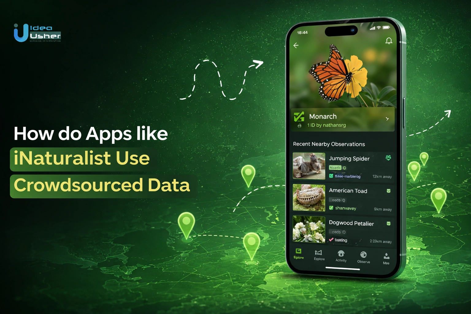
What Makes iNaturalist’s Data Model So Effective?
The effectiveness of this model lies in its ability to convert unstructured biological encounters into structured, research-ready datasets. Unlike general social media platforms where photos are purely aesthetic, this framework treats every upload as a unique evidence-based record. By prioritizing the relationship between a specific organism, its location, and the time of the sighting, the system creates a high-integrity audit trail that scientists can trust.

A. Observation-First Data Capture Approach
The platform focuses on “observation” as the primary unit of data. An observation is not just a photograph; it is a multi-dimensional record that anchors a biological event in space and time. This structured approach is fundamental to managing crowdsourced data in apps like iNaturalist, ensuring that every contribution follows a rigorous format required for scientific analysis.
- Mandatory Metadata: Every upload automatically attaches GPS coordinates and timestamps, removing the subjectivity of manual descriptions.
- Voucher Media: Photos or audio recordings serve as “vouchers,” providing the physical evidence needed for others to verify the sighting.
- Data Interoperability: By using standardized formats, the information can be easily exported to global repositories like the Global Biodiversity Information Facility (GBIF).
B. Combining AI Identification With Human Validation
One of the most sophisticated aspects of the architecture is the hybrid intelligence system. It utilizes Computer Vision to provide immediate gratification to the user, while relying on a peer-review mechanism to establish scientific “Grade” status. This dual-layer process ensures that speed does not come at the cost of accuracy.
| Validation Layer | Function | Purpose |
| Computer Vision (AI) | Analyzes image pixels against a massive training set of confirmed species. | Provides instant suggestions to help users narrow down the identification. |
| Community Peer Review | Allows other users and experts to agree, disagree, or refine the identification. | Reaches a “Research Grade” consensus when 2/3 of the community agrees. |
| Automated Quality Flags | Systems flag captive/cultivated organisms or location anomalies. | Filters out non-wild data that could skew ecological research. |
C. Turning Casual Users Into Data Contributors
A major challenge in the lifecycle of crowdsourced data in apps like iNaturalist is converting curious users into active contributors. By lowering the “taxonomic wall” and providing professional tools, the platform empowers beginners to feel like scientists from their very first upload.
- Low Barrier Identification: The AI suggests names, so users don’t have to guess or feel embarrassed by incorrect labels.
- Social Validation: When an expert confirms a casual user’s sighting, it creates a powerful psychological incentive to contribute again.
- Real-World Impact: Users receive notifications when their data is used in a scientific paper or a conservation project, closing the loop between a simple walk in the park and global environmental impact.

How Crowdsourced Data Flows Inside The Platform?
The integrity of a crowdsourced system relies on a rigorous pipeline that converts raw images into verified data. Understanding this lifecycle is essential for implementing crowdsourced data in apps like iNaturalist, ensuring information is refined and validated for the scientific record.

1. Guided Data Capture By Users
The quality of the final data is determined at the moment of capture. To prevent the database from being flooded with unusable entries, the platform uses specific interface cues to guide the user toward high-quality submissions.
- UX Prompts For Better Image Quality: The interface encourages users to take clear, centered, and well-lit photos, often providing overlays to help with framing.
- Auto-Capture Of Location & Timestamp: By automating the collection of GPS and time data, the system eliminates human error and ensures the record is anchored in a specific reality.
- Reducing Low-Quality Submissions: Early-stage filters can detect blurry or obstructed images, prompting the user to try again before the data is even uploaded.
2. User Uploads Geotagged Observation
Once the user confirms the capture, the app packages the media and its associated metadata into a single, structured entity. This step is where the raw encounter becomes a formal digital record.
| Data Component | Format | Purpose |
| Primary Media | JPEG/PNG/WAV | Visual or auditory proof of the species. |
| Spatial Data | Decimal Degrees | Precise coordinates for mapping distribution. |
| Temporal Data | ISO 8601 | Establishing the exact season and time of day. |
| User Metadata | Unique ID | Tracking the contributor for reputation and history. |
3. AI Suggests Species Identification
Immediately following the upload, a computer vision layer processes the image. This provides instant value to the user while acting as the first gate in the identification process.
- Computer Vision Analysis: The model compares the visual features of the upload against millions of pre-identified training images.
- Confidence Scores: The system does not just give one answer; it provides a list of matches with percentage-based confidence levels, often suggesting a broader genus if a specific species match is uncertain.
4. Community Validates Or Corrects Data
The human element remains the strongest safeguard against AI errors. A distributed network of users and subject-matter experts reviews the incoming stream to verify the automated suggestions.
- Peer Review: Other members of the community can agree with the current identification or suggest an alternative.
- Conflict Resolution: If disagreements occur, the system facilitates a discussion where users can provide taxonomic reasoning for their choice.
- Consensus Logic: This democratic approach ensures that no single user has total control over the identification, mitigating individual bias or error.
5. Data Reaches Research-Grade Quality
The quality of crowdsourced data in apps like iNaturalist is defined by the Research Grade threshold, ensuring records are accurate and useful for professional science.
- Confirmation Thresholds: A record typically needs at least two-thirds of the community to agree on a specific species level.
- Completeness Checks: Data must include a date, coordinates, and evidence (photo/audio) to qualify.
- Exclusion Rules: Entries marked as “captive” or “cultivated” are automatically filtered out of the primary research datasets to keep the focus on wild biodiversity.
6. Data Is Stored In Structured Databases
Once validated, the data is indexed within a robust backend architecture. This allows for the complex queries required by environmental researchers and developers.
- Relational Indexing: Observations are linked to taxonomic trees, geographic regions, and user profiles.
- High Availability: The infrastructure must be optimized for fast retrieval, as these datasets often grow to include hundreds of millions of individual records.
- Data Partitioning: Large-scale crowdsourced data in apps like iNaturalist is often partitioned by region or taxon to maintain search performance at scale.
7. Data Becomes Accessible For Real-World Use
The final stage of the flow is the transition from a private database to a public utility. This is where the effort of the crowd translates into actual conservation results.
- API Distribution: Developers and researchers can pull filtered datasets directly into their own models or mapping tools.
- Global Integration: Validated records are often pushed to international repositories like GBIF, ensuring the data contributes to global biodiversity trends.
- Conservation Impact: Government agencies and NGOs use this structured information to designate protected areas, track invasive species, and formulate environmental policy.
Core Data Types Collected In Nature Apps
These platforms must capture diverse data points to maintain scientific utility beyond simple images. Efficiently managing crowdsourced data in apps like iNaturalist requires a backend architecture that synchronizes these distinct information layers into a single, cohesive, and validated record.
| Data Category | Key Technical Inputs | Strategic Function in the Ecosystem |
| Image & Visual Biodiversity | Photos, videos, and multi-angle macro shots of species. | Acts as the primary evidence (voucher) for species identification and verification. |
| Location & Geospatial Tracking | GPS coordinates (lat/long), elevation, and mapping layers. | Offers critical insights into species distribution, habitat range, and invasive species movement. |
| Time-Based Observation | Precise timestamps (ISO 8601) and seasonal date markers. | Enables researchers to track migration patterns, blooming schedules, and lifecycle changes. |
| User Annotations & Discussions | Comments, identification suggestions, and expert corrections. | Facilitates community-driven knowledge building and provides the peer-review layer for integrity. |
| AI Identification & Confidence | Suggested species matches and probability/confidence scores. | Automates initial classification to lower entry barriers for non-expert contributors. |
| Environmental & Contextual | Weather data, altitude, soil type, and ecosystem classification. | Adds depth by linking sightings to specific climate, terrain, or environmental stressors. |
| User Behavior & Reputation | Contributor activity logs, accuracy rates, and trust scoring. | Establishes credibility based on the historical performance and expertise of the individual. |
AI + Crowd: The Hybrid Data Validation Engine
The synergy of AI and human intelligence forms the foundation of modern biodiversity platforms. This hybrid engine ensures that crowdsourced data in apps like iNaturalist remains accessible to the public while providing the rigorous verification required for professional scientific use.

A. Role Of Computer Vision In Species Detection
Computer vision serves as the primary gateway for data entry, transforming raw pixels into taxonomic suggestions. This layer is critical for maintaining user engagement by providing instant gratification and reducing the “identification gap” for non-experts.
- Pattern Recognition: Deep learning models are trained on millions of “Research Grade” images to identify specific morphological features, such as leaf shapes, wing patterns, or floral structures.
- Taxonomic Filtering: The AI often uses a hierarchical approach, identifying the broad “Kingdom” or “Phylum” with near-perfect accuracy before attempting to suggest a specific species.
- Scalability: Automated detection allows the platform to handle massive spikes in data during events like “City Nature Challenges” without overwhelming human moderators.
B. Why Human Verification Still Matters
Despite the advancements in machine learning, human expertise remains the gold standard for data integrity. AI can be easily misled by poor lighting, overlapping species, or mimicry in nature, whereas a human observer can apply contextual knowledge.
| Feature | AI Capabilities | Human Expert Value |
| Contextual Awareness | Limited to the pixels in the frame. | Understands habitat, seasonality, and rare variations. |
| Handling Mimicry | Often confused by species that look identical but are unrelated. | Can distinguish subtle differences in texture or behavior. |
| New Discoveries | Can only identify what is already in its training set. | Capable of identifying new species or anomalies never seen before. |
| Ethical Judgment | Cannot distinguish between wild and cultivated organisms. | Manually flags “captive” or “pet” status to maintain data purity. |
C. Confidence Scoring and Consensus Mechanisms
The platform uses a structured consensus mechanism to bridge the gap between AI suggestions and human review. This ensures that no single identification either AI or human is treated as absolute truth without verification.
- Probability Thresholds: The AI generates a confidence score for its suggestions; if the score is too low, the system prompts for “Generic” identification to avoid spreading misinformation.
- Community Agreement: A record only advances in quality when multiple independent users agree on a specific identification.
- Weighted Consensus: The system requires a two-thirds majority to reach a “Research Grade” status, creating a democratic yet rigorous filter for crowdsourced data in apps like iNaturalist.
D. Handling Conflicting Identifications
Disagreements are a natural part of the scientific process. The platform must provide a clear framework for resolving these conflicts without discouraging user participation.
- Taxonomic Discussion: Users can provide comments and evidence (such as links to academic keys) to justify their identification, turning a conflict into an educational opportunity.
- Withdrawal and Refinement: Users have the option to withdraw their identification if presented with convincing counter-evidence, allowing the consensus to shift dynamically.
- Quality Flags: If a conflict cannot be resolved, or if the data appears fraudulent, “Quality Flags” can be used to remove the observation from the scientific export pool while keeping it visible on the social platform.
How Data Becomes Research-Grade and Reliable?
The transition from casual snapshots to scientific records is governed by a rigorous validation framework. This structured process differentiates crowdsourced data in apps like iNaturalist from social media by prioritizing empirical accuracy over aesthetic value for global biodiversity databases.

A. “Research Grade” Criteria Explained
For an observation to be classified as “Research Grade,” it must fulfill a specific checklist of data integrity requirements. This status acts as a digital seal of approval, signaling to the global scientific community that the record is complete, evidenced, and verified.
- Evidence of Presence: The record must include a photo or sound recording that clearly depicts the organism.
- Contextual Accuracy: A precise date and geolocated coordinates are mandatory to anchor the find in time and space.
- Community Consensus: At least two-thirds of the contributors must agree on a specific species-level identification.
- Wild Status: The organism must be wild; sightings of pets, garden plants, or zoo animals are automatically disqualified from this tier.
B. Peer Validation & Reputation Systems
Reliability is maintained through a decentralized peer-review system where the community acts as a collective editorial board. This system balances the contributions of newcomers with the established expertise of veteran naturalists.
| Validation Layer | Mechanism | Impact on Reliability |
| Independent Reviews | Multiple users must independently identify the same species without seeing previous guesses. | Minimizes “herding behavior” where users simply agree with the first suggestion. |
| Expert Intervention | Identifications from users with high accuracy “scores” in specific taxa carry more weight. | Ensures that difficult-to-distinguish species are vetted by those with deep domain knowledge. |
| Reputation Loops | Users who consistently provide verified data gain community trust and higher visibility. | Encourages long-term accuracy and discourages careless or “guess-based” submissions. |
C. Filtering Noise & Inaccurate Submissions
A major technical challenge in managing crowdsourced data in apps like iNaturalist is the removal of “noise” data that is redundant, incorrect, or intentionally misleading. Sophisticated filtering algorithms and manual flags work in tandem to keep the database clean.
- Automated Quality Flags: The system automatically flags observations with impossible dates (e.g., in the future) or locations (e.g., a marine species found in a desert).
- Spam Detection: Algorithms monitor for bulk uploads of non-biological content or repetitive, low-value imagery.
- Community Flagging: Users can mark observations as “inappropriate,” “missing evidence,” or “captive,” which immediately removes them from the research-grade pipeline for further review.
D. Ensuring Scientific Usability Of Data
The ultimate goal of the validation engine is to produce a dataset that is “clean” enough for use in peer-reviewed research and conservation policy. This requires the data to be formatted for seamless integration with professional tools.
- Standardized Taxonomy: All identifications are mapped to a global taxonomic backbone, ensuring that regional common names do not lead to data fragmentation.
- Open Access APIs: Validated data is pushed to platforms like the Global Biodiversity Information Facility (GBIF), where it can be queried by researchers worldwide.
- Data Provenance: Every record maintains a full history of its identification path, allowing scientists to trace the consensus and verify the credentials of the validators.
Real Use Cases Of Crowdsourced Biodiversity Data
The transition from individual observations to global impact is best demonstrated through tangible environmental successes. By aggregating millions of data points, these platforms provide a high-definition view of the natural world.

1. Wildlife Conservation & Habitat Tracking
Crowdsourced observations provide essential data for monitoring threatened species and mapping critical habitats without expensive traditional field surveys. This allows conservationists to identify areas requiring immediate protection based on recent, verified species sightings.
Real-World Example: The Oregon Wildlife Conservation Project uses iNaturalist to document 109 strategy species, directly augmenting state-managed conservation plans and habitat restoration.
2. Climate Change & Migration Studies
Researchers use large-scale datasets to track phenological shifts, such as earlier flowering times or altered migration routes. These patterns offer a real-time pulse on how global temperature increases are fundamentally changing biological timing.
Real-World Example: Researchers have used this data to model off-season Yucca blooms and track shifts in North American bird migration routes via submission patterns.
3. Academic & Institutional Research
Universities integrate these datasets into peer-reviewed studies to address large-scale ecological questions that require massive sample sizes. This democratization of data allows for global studies that would be logistically impossible for single institutions.
Real-World Example: Community-contributed photographs led to the discovery of a new iris-like flower species in South Africa, which was subsequently published in a major academic journal.
4. Government & NGO Environmental Programs
Public agencies leverage these platforms for the early detection of invasive threats and the management of natural resources. This data helps governments designate protected areas and allocate funding for environmental mitigation projects.
Real-World Example: Organizations like NatureServe use the data to create biodiversity indicators, helping governments manage the spread of invasive species like the spotted lanternfly.
Challenges In Crowdsourced Data Systems
Building a high-integrity data engine requires overcoming significant technical and social hurdles. From ensuring taxonomic accuracy to protecting user privacy, the architecture must be resilient. Our development team implements sophisticated, automated safeguards to maintain the quality of crowdsourced data in apps like iNaturalist.

1. Data Accuracy & Misinformation Risks
Challenge: Incorrect identifications or intentional spam can compromise the scientific validity of the database, leading to flawed ecological research and models.
Solution: Our developers implement multi-layered verification pipelines, using high-confidence AI filtering and reputation-based consensus logic. We ensure only data vetted by trusted community members reaches the research-grade export tier.
2. User Engagement Consistency Issues
Challenge: Many platforms suffer from high churn rates, where users stop contributing after their initial curiosity about a species is satisfied.
Solution: We integrate gamification elements, such as “collection” badges and regional challenges. Our developers use targeted push notifications to alert users when their specific observations have contributed to real-world scientific discoveries.
3. Scaling Moderation & Validation
Challenge: As the user base grows, the volume of incoming data can easily overwhelm a manual, human-only moderation and review system.
Solution: We deploy server-side automation that handles the initial categorization and metadata validation. This allows our architecture to scale infinitely, reserving human expert intervention for the most complex or rare taxonomic conflicts.
4. Privacy Concerns With Location Data
Challenge: Sharing precise GPS coordinates can expose the locations of endangered species to poachers or compromise the personal privacy of contributors.
Solution: Our developers utilize spatial “obscuration” algorithms that blur exact coordinates for sensitive entries. We implement rigorous permission controls and end-to-end encryption to ensure that personal location data remains secure and private.
How Top Apps Solve Crowdsourcing Challenges?
The effective management of crowdsourced data in apps like iNaturalist requires engineering ecosystems that balance user growth with scientific integrity. By blending social engagement with automated verification, these platforms mitigate misinformation risks to ensure high-quality participation and long-term viability.
1. Gamification & Contribution Incentives
Engagement is the lifeblood of crowdsourcing. To prevent user churn, top-tier apps transform data collection into a rewarding experience that mirrors social gaming without compromising the scientific mission.
- Progressive Achievement Systems: Users earn digital badges and level up based on the rarity of their finds or the accuracy of their identifications.
- Regional Leaderboards: Localized challenges, such as “BioBlitz” events, encourage healthy competition and a sense of community pride.
- Impact Feedback: Automated notifications inform contributors when their data is used in a research paper, providing a sense of tangible contribution to global science.
Example: Seek by iNaturalist successfully addresses engagement by using an achievement-based system where users earn digital badges and level up by completing “scavenger hunt” challenges to find specific species in their local area.
2. Community Moderation Models
To scale beyond the capacity of a central staff, successful apps decentralize the validation process. This turns the user base into a self-correcting organism where collective knowledge outweighs individual error, ensuring the integrity of crowdsourced data in apps like iNaturalist.
- Decentralized Peer Review: Multiple independent users must confirm a species identification before it reaches a higher quality status, minimizing the impact of amateur mistakes.
- Transparent Conflict Resolution: Public discussion threads allow for evidence-based taxonomic debate, creating a permanent and educational record of how a community consensus was reached.
- Automated Flagging Systems: Community members can trigger manual audits for observations that appear captive, cultivated, or geographically displaced, maintaining the purity of wild biodiversity datasets.
Example: iNaturalist utilizes a decentralized peer-review system where an observation only reaches “Research Grade” status once at least two-thirds of the community agrees on the identification, ensuring that collective expertise outweighs individual error.
3. AI-Assisted Data Cleaning Pipelines
Raw crowdsourced data is often “noisy,” containing duplicates, blurred images, or incorrect metadata. Advanced pipelines use machine learning to sanitize this data before it ever reaches a human reviewer.
- Visual Quality Filtering: AI instantly flags photos that are too blurry or dark, prompting the user to retake the image in real-time.
- Anomaly Detection: Algorithms cross-reference sightings with known distribution maps; a “polar bear in a jungle” is immediately flagged for manual audit.
- Deduplication: Systems identify and merge multiple uploads of the same individual organism by different users to prevent over-counting in population studies.
Example: The PlantNet app employs a visual quality filter that uses computer vision to instantly analyze a photo’s clarity; if the image is too blurry or the subject is not a plant, the system prompts the user to retake it before it enters the database.
4. Trust-Building Through Transparent Systems
Transparency is essential for maintaining the “Scientific Grade” reputation of a platform. Users and researchers must be able to see exactly how data moves through the system to trust its output.
- Open Audit Trails: Every change to a record from the initial upload to the final identification is timestamped and attributed to a specific user.
- Data Privacy Shields: Precise location data for sensitive species is automatically obscured from the public to prevent poaching while remaining accessible to verified researchers.
- Exportable Datasets: By allowing anyone to download and verify the raw data via public APIs, platforms prove they have nothing to hide, cementing their status as a reliable public utility.
Example: The Global Biodiversity Information Facility (GBIF) maintains scientific trust by providing a complete open audit trail for every record, allowing researchers to see the full history of identifications and the specific contributors involved for every data point used in their studies.
Key Features Behind Successful Data Collection Apps
The architecture of a premier nature platform hinges on balancing a frictionless user experience with rigorous data integrity. By integrating advanced automation, these apps turn casual observations into verified scientific assets.

1. Seamless Observation Upload UX
Reducing technical friction is critical for maintaining high contribution volumes. Modern interfaces utilize a “capture-to-cloud” workflow with minimal steps, incorporating smart UI prompts that guide users toward optimal lighting and framing to prevent the submission of unusable, low-quality biological records.
2. Real-Time AI-Powered Identification
Immediate gratification drives retention through computer vision layers that analyze morphological features instantly. These systems provide species matches accompanied by confidence-based recommendations, allowing non-experts to contribute meaningful data while the AI handles the heavy lifting of initial taxonomic classification.
3. Community Validation & Feedback Loops
Scientific accuracy is established through a decentralized peer-review mechanism where independent users verify sightings. This consensus-driven approach ensures that crowdsourced data in apps like iNaturalist remains reliable, as expert corrections provide a necessary layer of human oversight to the AI.
4. Offline Data Capture & Sync Capabilities
Ecological research often occurs in remote regions without cellular connectivity. Successful platforms implement robust local caching, allowing users to log geotagged observations in the field and trigger automatic background synchronization once the device re-establishes a stable internet connection.
5. Gamification & Contributor Incentives
Sustaining long-term engagement requires psychological rewards such as digital badges, streaks, and localized leaderboards. These incentives transform repetitive data collection into a compelling experience, encouraging consistent participation and turning occasional hobbyists into dedicated, high-volume contributors within the citizen science ecosystem.
6. Data Validation & Quality Control Systems
Maintaining a clean database requires multi-layer verification pipelines that automatically filter out inaccurate or duplicate submissions. These systems cross-reference metadata against known species ranges, ensuring that only high-integrity, “wild” observations are promoted to research-grade datasets for professional use.
7. Scalable Data Storage & Processing Systems
Handling millions of high-resolution images requires a sophisticated cloud infrastructure capable of real-time processing. Developers must build elastic pipelines that can ingest massive data spikes during global events, ensuring that indexing and retrieval remain performant as the database grows.
8. User Reputation & Trust Scoring Systems
Data reliability is enhanced by tracking the historical accuracy of each contributor. By assigning credibility scores to users who consistently provide verified identifications, the system can weight their input more heavily, effectively isolating spam and improving the overall trustworthiness of the network.
Tech Stack Behind Crowdsourced Data Platforms
Building a high-performance biodiversity engine in 2026 requires more than basic web tools; it demands an ecosystem capable of processing massive spatial data and real-time AI inference. The following table highlights the advanced, industry-standard technologies necessary to manage crowdsourced data in apps like iNaturalist at a global scale.
| Infrastructure Layer | Advanced Tech Selection | Strategic Function & Business Value |
| Edge AI & Vision | Vision Transformers (ViT) via TensorFlow Lite | Enables sophisticated, on-device species identification even without a signal, reducing server costs and providing instant user feedback. |
| Geospatial Engine | PostgreSQL with PostGIS | The gold standard for spatial queries, allowing the platform to handle millions of complex “find species near me” requests simultaneously. |
| Real-Time Data Stream | Apache Kafka or Redpanda | Processes incoming observations as “events,” allowing for instant community notifications and live biodiversity heatmaps. |
| Scalable Vector Search | Pinecone or Milvus | Uses vector embeddings to find visually similar species across billions of images in milliseconds, powering the “suggested matches” feature. |
| MLOps & Retraining | MLflow or Kubeflow | Automates the lifecycle of AI models, ensuring they get smarter every time a human expert corrects an identification in the field. |
| High-Concurrency API | GraphQL (Apollo) | Optimized for mobile, ensuring the app only downloads the specific data needed (e.g., just the species name, not the whole metadata) to save battery. |
| Distributed Storage | Cloudflare R2 or AWS S3 | Globally distributed object storage that ensures high-resolution evidence photos load instantly for reviewers regardless of their country. |
Key Technical Considerations for Implementation
- Decoupled Architecture: By separating the data management layer from the user interface, developers can update the AI models or database structures without needing to force a mobile app update on all users.
- Geospatial Indexing: Using GIST indexes within a spatial database is the difference between a map that takes 10 seconds to load and one that is interactive and fluid.
- Event-Driven Validation: Every upload should trigger a chain of microservices including one for AI identification, one for location validation, and one for community notification to ensure the system remains modular and easy to maintain.
Designing UX For Maximum User Contributions
The success of a data-driven platform depends on its ability to convert casual curiosity into consistent participation. A well-designed user experience minimizes the cognitive load of data entry while maximizing the emotional rewards of contributing to a global scientific mission.
1. Reducing Friction In Data Submission
The interface must prioritize speed and simplicity to ensure that the moment of discovery is captured before the opportunity passes. Every additional tap in the workflow increases the likelihood of user abandonment.
- One-Tap Camera Integration: Positioning the capture tool as the central action on the home screen ensures users can document sightings instantly.
- Automated Field Population: Leveraging native hardware to pull GPS, altitude, and timestamps removes the need for manual data entry and reduces human error.
- Progressive Disclosure: Initially asking only for the most vital information like the image and location prevents users from feeling overwhelmed by complex taxonomic forms during the upload process.
2. Making Contributions Feel Rewarding
Users are more likely to return when they perceive their actions as having a tangible impact. The UX should close the loop between a private observation and its public, scientific value.
- Real-Time Identification Feedback: Providing an instant AI-generated suggestion validates the user’s effort immediately, transforming a simple photo into a learning moment.
- Impact Notifications: Sending alerts when an observation is promoted to “Research Grade” or cited in a study provides a powerful sense of purpose and achievement.
- Community Validation Alerts: Real-time updates when an expert agrees with or corrects an identification foster a sense of connection to a larger, global scientific network.
3. Building Habit-Forming Engagement Loops
To transition from a one-time downloader to a dedicated contributor, the app must integrate into the user’s lifestyle. Habit-forming mechanics encourage regular exploration and consistent data generation over time.
- Personal Collection Analytics: Visualizing a user’s “Life List” or species discovery map encourages them to fill in the gaps in their personal biodiversity database.
- Contextual Challenges: Utilizing location-based triggers to invite users to join “BioBlitzes” or local seasonal missions turns data collection into a time-sensitive, social event.
- Daily Streaks and Milestones: Implementing subtle progress markers rewards consistent daily participation without detracting from the platform’s primary scientific focus.
4. Educating Users While They Contribute
A sophisticated UX turns data collection into an educational journey, increasing the quality of crowdsourced data in apps like iNaturalist as users become more knowledgeable and skilled over time.
- Interactive Taxonomic Keys: Providing visual side-by-side comparisons between similar species helps users learn the subtle morphological differences during the identification phase.
- Photography Best Practices: Inline tips such as “try to get the underside of the leaf” guide users to provide the specific visual evidence experts need for verification.
- Expert Commentary Access: Making the reasoning behind expert identifications visible allows amateurs to learn professional taxonomic logic, gradually improving the accuracy of the entire community.
Monetization Without Breaking Trust
Sustainable revenue models for biodiversity platforms must prioritize data integrity and community trust over aggressive commercialization. Successful strategies balance operational costs with the ethical mandate to keep scientific data accessible and transparent.
1. Grants, Partnerships & Sponsorships
Strategic alliances with environmental NGOs and academic institutions provide essential non-dilutive funding. By aligning with organizations like National Geographic, platforms secure long-term capital while reinforcing their mission-driven identity and expanding their global reach.
2. API Access For Research Institutions
Charging for high-volume, structured data access allows the platform to monetize its unique assets without restricting casual users. Research institutions and environmental consultants pay for specialized tools that streamline the ingestion of validated ecological records.
3. Premium Tools For Advanced Users
Offering specialized features such as advanced spatial analytics, bulk export capabilities, or offline project management creates a tiered value proposition. This allows power users to support the platform financially while keeping core observation tools free.
4. Ethical Data Monetization Strategies
Platforms can monetize anonymized, aggregated biodiversity trends for urban planning and environmental impact assessments. This approach provides immense value to government agencies and sustainable developers while strictly protecting the privacy and trust of individual contributors.
Case Insight: What Founders Can Learn From iNaturalist
Analyzing the trajectory of iNaturalist reveals a strategic blueprint for high-impact platforms. Success in this space is not merely a result of technical execution, but of carefully balancing scientific rigor with community growth. For those exploring the potential of crowdsourced data in apps like iNaturalist, these insights serve as a roadmap for building a platform that is both socially valuable and structurally sound.
A. Building A Mission-Driven Product
A strong, clear mission acts as the North Star for product development, ensuring that every new feature serves the ultimate goal of ecological discovery. This clarity attracts a dedicated user base that feels a sense of ownership over the platform’s success.
- Values-First Architecture: Decisions regarding data open-access and species privacy are made based on ethical impact rather than short-term metrics.
- Purpose over Profit: By prioritizing “Research Grade” data, the platform establishes itself as a credible scientific tool, which inadvertently builds a more loyal and high-quality user community.
- Alignment with Global Goals: Connecting the app’s output to global biodiversity targets makes the product relevant to international policy and large-scale funding.
B. Scaling Community Before Monetization
The “cold start” problem is solved by focusing on the value of the network before introducing revenue-generating features. A robust, active community is the most significant asset a crowdsourced platform can possess.
| Growth Phase | Primary Focus | Long-term Outcome |
| Initial Seed | Recruiting taxonomic experts and power users. | Establishes the quality baseline for all future data. |
| User Expansion | Lowering barriers for casual explorers via AI. | Generates the “Big Data” volume needed for research. |
| Network Maturity | Facilitating peer-to-peer mentorship and debate. | Creates a self-moderating system that reduces overhead. |
C. Leveraging Partnerships For Credibility
Trust is the primary currency in the scientific and environmental sectors. Partnering with established institutions provides an immediate “seal of approval” that would otherwise take decades to build.
- Institutional Backing: Aligning with organizations like National Geographic provides a massive distribution network and editorial authority.
- Academic Integration: When universities use the platform for official coursework, it ensures a steady stream of high-quality, supervised data.
- Cross-Platform Data Sharing: Integrating with global databases like GBIF makes the platform indispensable to the international scientific community.
D. Creating Long-Term User Retention Loops
Retention in a data-centric app requires more than just notifications; it requires a sense of ongoing discovery and personal growth. The platform must evolve alongside the user’s increasing expertise.
- The Learning Curve as a Feature: As users identify more species, the app provides more advanced tools and more challenging “missions.”
- The Social Validation Loop: Being thanked by a scientist or seeing one’s photo used in a report provides an emotional “hook” that generic gamification cannot match.
- Personal Knowledge Bases: Allowing users to curate their own digital “museum” of finds turns the app into a lifelong repository of their outdoor experiences.
Cost Drivers Of Building Crowdsourced Data Apps
The investment for high-integrity platforms exceeds standard development due to complex validation and specialized AI. Understanding these financial pillars is essential for stakeholders evaluating the scalability and viability of crowdsourced data in apps like iNaturalist.
A. AI Development & Training Costs
Developing a computer vision model capable of distinguishing between thousands of visually similar species is a significant technical undertaking. This requires high-performance computing power and a clean, labeled dataset to ensure the accuracy necessary for scientific use.
- Data Labeling: Thousands of hours of expert-verified imagery are required to train a reliable taxonomic model.
- Model Refinement: Continuous retraining cycles are necessary as the database grows and new species are added.
- Compute Resources: Utilizing GPUs for deep learning training and real-time inference at scale represents a consistent operational expense.
B. Backend Infrastructure & Scaling
The backend must be engineered to handle massive, unstructured media uploads while maintaining a responsive user experience. As the community grows, the infrastructure must scale elastically to prevent latency during high-traffic events.
- Geospatial Indexing: Specialized database management for millions of coordinates requires high-performance cloud instances.
- Media Storage: Hosting millions of high-resolution “voucher” photos requires durable, globally distributed object storage.
- API Throughput: Supporting external research requests and internal community interactions demands a high-bandwidth, redundant server architecture.
C. UX & Mobile App Development
The mobile interface is the primary tool for data collection and must function flawlessly in diverse environmental conditions. This involves native hardware integration and a design language that caters to both amateur hobbyists and professional researchers.
| Development Component | Focus Area | Impact on Budget |
| Native Integration | Camera, GPS, and Offline Caching. | High complexity for cross-platform stability. |
| User Onboarding | Guided tutorials and “smart” upload prompts. | Critical for reducing user churn and data noise. |
| Feature Set | Maps, Life Lists, and Social Feeds. | Drives long-term engagement and platform value. |
D. Moderation & Community Systems
A self-sustaining data ecosystem requires sophisticated social architecture. Investing in robust moderation tools reduces the long-term cost of manual data cleaning and ensures the platform remains a trusted scientific resource.
- Reputation Logic: Developing custom algorithms to weight user identifications based on historical accuracy.
- Conflict Resolution Tools: Building transparent discussion frameworks for taxonomic debate.
- Automated Flagging: Implementing server-side logic to detect and remove spam or non-wild observations automatically.
How IdeaUsher Builds Scalable Data-Driven Apps?
IdeaUsher specializes in transforming complex data requirements into intuitive, high-performance digital ecosystems. We combine advanced engineering with user-centric design to ensure your platform remains resilient, accurate, and ready for global scale.
A. Our Approach To AI + Crowdsourcing Systems
We engineer intelligent pipelines that blend automated neural modeling with human-in-the-loop validation. By deploying custom computer vision and RAG architectures, we ensure your app processes massive datasets while maintaining the highest levels of accuracy.
B. Experience In Building Community Platforms
With over 1,000 projects completed, we excel at creating vibrant digital spaces that foster high engagement. Our expertise includes developing robust social infrastructures with real-time interaction, reputation-based trust systems, and advanced moderation tools for global users.
C. End-To-End Development & Scaling Support
From initial technical viability mapping to post-launch optimization, we provide a comprehensive lifecycle for your product. Our team ensures your infrastructure is built for “monster scale,” utilizing elastic cloud configurations that grow alongside your userbase.
D. Custom Solutions For Data-Intensive Apps
We build bespoke architectures tailored to high-complexity operational hurdles, such as real-time geospatial tracking and multi-module data analytics. Our solutions prioritize low-latency performance and secure data foundations, ensuring a seamless experience for even the most demanding users.
E. Strategic MVP To Market Acceleration
We focus on rapid, high-quality deployment that aligns your executive vision with technical reality. By architecting a lean yet scalable MVP, we help you secure early market traction and validate your core features before expanding into full-scale operations.
Planning To Build A Crowdsourced App With IdeaUsher!
Building a high-performance biodiversity platform requires elite engineering and strategic depth. At IdeaUsher, our team of ex-FAANG/MAANG developers leverages over 500,000+ hours of development experience to architect secure, scalable, and AI-driven ecosystems.
Whether you are navigating complex geospatial tracking or high-volume data validation, we provide the technical mastery and industry insight needed to transform your vision into a market-leading digital reality.
Why Hire Us?
- Validate Your Idea With Experts: Work alongside seasoned consultants to refine your product’s value proposition and ensure technical viability before full-scale investment.
- Identify Your Target Contributor Base: We help you map user personas and engagement strategies to build a self-sustaining community of high-quality data contributors.
- Choose The Right Technology Stack: Benefit from our deep expertise in selecting the most efficient, future-proof frameworks for AI, cloud storage, and real-time processing.
Partner with IdeaUsher for development and leverage our world-class engineering team to build a robust, scalable, and high-impact crowdsourced data platform today.
Conclusion
The development of a high-impact biodiversity platform requires a strategic integration of mobile technology, artificial intelligence, and community-driven validation. By prioritizing data integrity and user engagement, developers can build a self-sustaining ecosystem that transforms casual observations into vital scientific assets. Successfully managing crowdsourced data in apps like iNaturalist bridges the gap between public curiosity and professional research, creating a powerful tool for global conservation. Ultimately, these platforms prove that when technology empowers the collective, we can achieve a real-time, scalable understanding of our planet.
FAQs
A.1. Accuracy is maintained through a hybrid validation engine. By combining AI-powered initial filtering with a decentralized community peer-review system, platforms can verify raw submissions and filter out noise or misinformation effectively.
A.2. Yes, crowdsourced data is widely accepted when it meets a specific quality threshold like “Research Grade.” Global databases like the Global Biodiversity Information Facility (GBIF) integrate this verified information, making it accessible for peer-reviewed studies and government conservation planning.
A.3. The primary risk involves revealing the locations of endangered species or private property. To mitigate this, platforms use automated “geoprivacy” tools that obscure precise coordinates for sensitive sightings, ensuring data utility while protecting vulnerable ecosystems and user privacy.
A.4. Machine learning provides an immediate feedback loop by suggesting identifications and flagging low-quality images. This reduces the burden on human moderators by filtering out noise, allowing experts to focus their efforts on verifying complex or scientifically significant observations.


