


Nature observation is becoming more interactive as people use mobile apps to identify species, document sightings, and contribute to shared ecological knowledge. Beyond passive exploration, users now expect interactive tools for species recognition track observations, and connect them with the community, driving interest in iNaturalist app development, integrating image recognition and geolocation to turn simple observations into verified, real-world ecological data.
The integration of image processing, location tracking, species databases, community interactions, and data validation systems is what transforms this concept into a reliable platform. The effectiveness of the app depends on how well these components support accurate identification while encouraging user participation and long-term engagement.
In this blog, we explain how to develop an app like iNaturalist in 2026 by examining core features, system architecture, and practical considerations involved in building a scalable and community-driven nature discovery platform.
Why Build A Citizen Science App In 2026?
The intersection of ecological awareness and mobile technology has created a unique opportunity for high-impact digital products. Developing a platform in this space allows for the collection of vital environmental data while fostering a global community of contributors. The shift toward sustainable and data-driven conservation in 2026, makes this a strategic time for such a venture.
A. Market Demand For Biodiversity & Climate Tech Apps
The global focus on environmental health has catalyzed rapid growth in climate tech, with the wildlife sighting citizen science app market projected to grow from USD 0.41 billion in 2024 to USD 1.23 billion by 2033 at a CAGR of 14.7%, highlighting strong momentum in digital citizen science engagement and app development opportunities.

Modern biological data is now a critical economic requirement for regulatory compliance. Remarkably, citizen scientists provide over 50% of the data for global biodiversity goals, contributing 100 million+ verified records to GBIF via platforms like iNaturalist for peer-reviewed research.
| Factor | Description |
| ESG Reporting | Corporations need accurate data to report their impact on local ecosystems and fulfill sustainability mandates. |
| Eco-Tourism | Travel sectors are integrating nature-discovery tools to enhance guest experiences and promote conservation. |
| Urban Planning | Cities utilize biodiversity data to design green spaces that support local wildlife and improve air quality. |
B. Rise Of Citizen Science Platforms
Digital platforms have democratized the scientific process by allowing non-professionals to contribute to high-level research. This movement thrives on the collective power of millions of users who act as distributed sensors across the globe.
- Massive Data Scaling: Traditional research is limited by personnel and budget, whereas citizen science scales at the rate of app downloads.
- Hyper-Local Insights: Users provide data from remote or private locations that professional scientists might never access.
- Community Retention: Users stay engaged because their activity has a tangible purpose, contributing to a global database used by real researchers.
- Verification Loops: Community-driven validation ensures that the data remains high-quality and research-grade.
C. Government & NGO Funding Opportunities
Public and private institutions are heavily investing in digital infrastructure that supports environmental monitoring. Successful iNaturalist app development often involves tapping into these diverse financial ecosystems to ensure long-term viability and growth.
- Innovation Grants: Many environmental agencies offer non-dilutive funding for technology that solves data gaps in biodiversity.
- Public Contracts: Municipalities often seek partnerships with platforms that help them track invasive species or monitor protected areas.
- Research Partnerships: Universities and NGOs frequently provide institutional support for apps that can generate reliable data for peer-reviewed studies.
D. Increasing Adoption Of AI-Based Nature Apps
Advanced machine learning has significantly lowered the entry barrier for new users. In 2026, integrated artificial intelligence handles the heavy lifting of identification, making the experience seamless and highly educational.
- Computer Vision Accuracy: Modern models can identify thousands of species from a single photo with near-perfect precision.
- Automated Geolocation: High-precision GPS and metadata tagging ensure every observation is pinned to a specific time and place without user effort.
- On-Device Processing: Edge AI allows users to identify species in remote areas without an active internet connection, ensuring the app remains functional in deep nature.
- Pattern Recognition: AI helps in spotting trends, such as the early migration of birds or the spread of plant diseases, providing early warnings for ecological shifts.
What Is an iNaturalist? A Quick Platform Breakdown
iNaturalist is a nature discovery and citizen science app that enables users to identify plants, animals, and fungi while contributing real-world biodiversity data to scientific research.
Built as a nonprofit initiative by organizations like the California Academy of Sciences and National Geographic, it combines AI-powered species recognition with a global community of scientists and naturalists, allowing users to upload simple photographs into verifiable data points, the platform creates a living record of Earth’s biodiversity that is accessible to everyone.

A. Core Concept And Ecosystem
The ecosystem operates on a specific workflow designed to turn a personal discovery into a global asset. Every interaction within the app contributes to a larger scientific repository known as the Global Biodiversity Information Facility (GBIF).
- The Observation: The primary unit of the platform. It consists of a media file (photo or audio), a timestamp, and GPS coordinates.
- The Identification: A collaborative process where the observer or other users propose a taxonomic name for the organism.
- Research Grade Status: Once the community reaches a consensus on an identification, the observation is elevated to “Research Grade,” making it eligible for use in professional scientific studies.
- Projects and Places: The platform allows users to create specific umbrellas for data collection, such as “Birds of the Amazon” or “Backyard Bioblitzes,” to organize localized efforts.
B. Role Of Community + AI
The synergy between human expertise and machine learning is what makes iNaturalist app development so effective. Neither component works in isolation; instead, they create a redundant system of checks and balances that ensures data integrity.
| Component | Function in the Ecosystem |
| Computer Vision AI | Provides instant identification suggestions based on visual patterns from millions of previously vetted images. |
| Crowdsourced Validation | Expert naturalists and enthusiasts review AI suggestions to correct errors and provide nuanced taxonomic details. |
| Learning Loops | As humans correct the AI, the machine learning models are retrained, becoming more accurate over time. |
| Social Mentorship | Experienced users teach beginners through comments, turning the app into a massive, decentralized classroom. |
C. How It Differs From Typical Social Apps
While traditional social media focuses on personal status and vanity metrics, a citizen science platform is built around “verifiable truth.” The architectural priorities shift from viral engagement to data accuracy and utility.
- Objective vs. Subjective Content: Posts on typical apps are about opinions or lifestyle; on this platform, every post is a claim about a biological fact that must be supported by evidence.
- Data Permanence: Most social content has a short lifespan. In contrast, an observation made today remains valuable to researchers decades from now as a historical record of a species’ range.
- The “Like” vs. The “Agreement”: Engagement is not about popularity. A “like” on a typical app is replaced by an “Agreement” on the identification, which serves a functional role in the data validation process.
- Utility for Third Parties: Unlike closed-loop social networks, the data generated here is designed to be exported and used by external entities like National Geographic and various global research institutions.

How iNaturalist Works: End-to-End User Flow?
iNaturalist transforms personal nature encounters into open-source scientific data through a collaborative pipeline involving mobile technology, artificial intelligence, and expert community review.

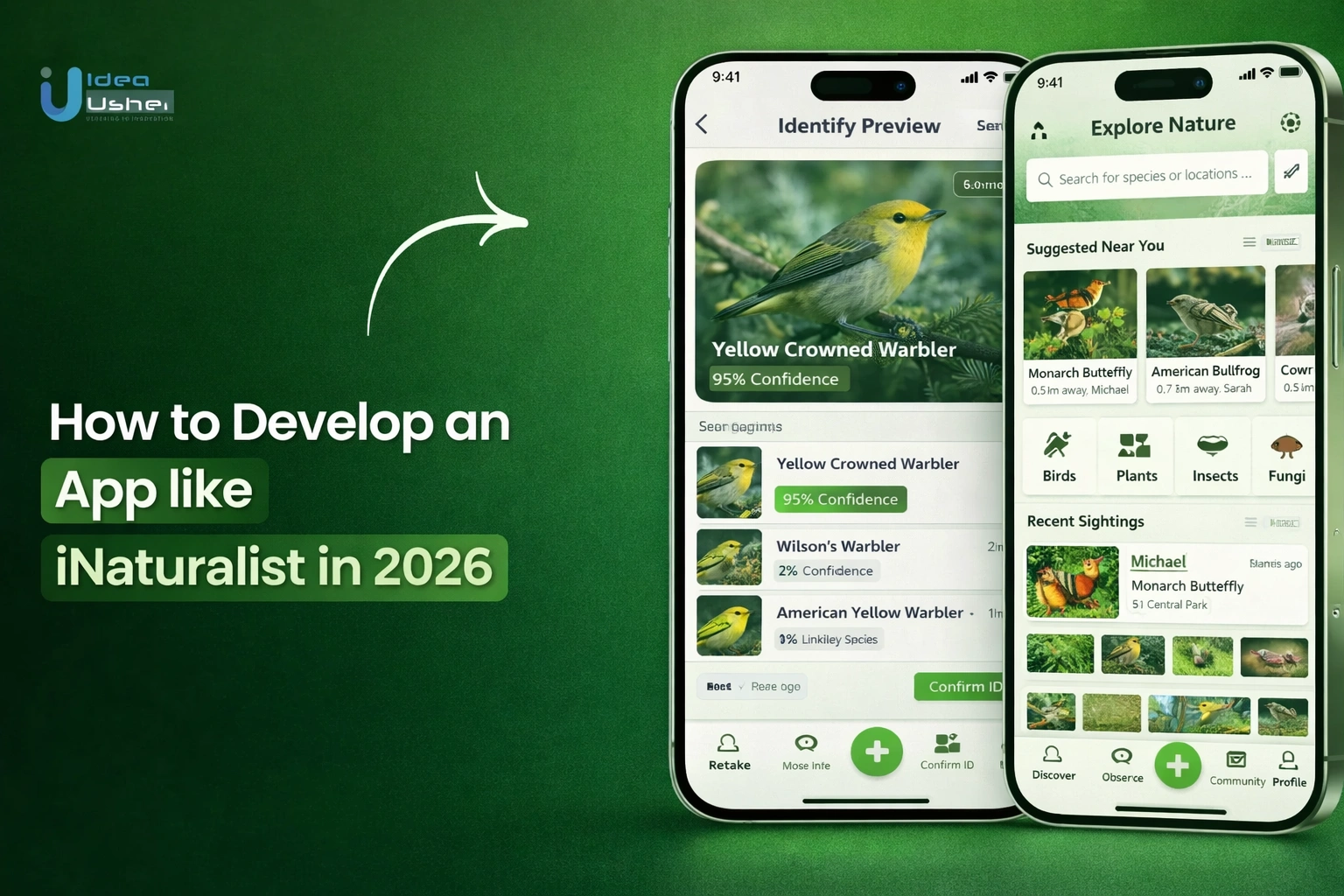
1. Capture and Upload Observations
Users record encounters with wild organisms using the iNaturalist mobile app or website. A valid observation must include:
- Evidence: One or more clear photos or a sound recording.
- Metadata: The date, time, and precise geographic coordinates (usually captured automatically by GPS).
- Wild Status: Observations should be of “wild” organisms, not captive pets or garden plants.
2. AI Suggests Species Identification
Upon upload, iNaturalist’s Computer Vision (CV) system analyzes the media to provide real-time suggestions.
- Visual Similarity: The AI identifies patterns like shape and colour to find matches in its database.
- Nearby Presence: Suggestions are filtered by species previously seen in that specific geographic area to increase accuracy.
- Initial ID: Users can select a specific species or a broader “placeholder” taxon (like “Fungi” or “Insects”) if they are unsure.
- The “Unknown” Loop: If the AI fails or the user is unsure, they can simply upload the observation as a broad category (like “Plants” or even just “Life”). This “placeholder” allows the community to find and categorize the observation later.
3. Community Validation & Discussion
Once uploaded, the observation is marked as “Needs ID” and enters the public Identify portal for community review.
- Agreement: Other users (experts or enthusiasts) view the evidence and either agree with the current ID or suggest a more accurate one.
- Discussion: Users can use the Activity tab to ask questions or provide reasoning for specific identifications.
- Consensus: The “Community Taxon” is determined by a 2/3 majority consensus among all identifiers.
- Identification Conflict: If users disagree, the “Community Taxon” can shift back and forth as new evidence or expert opinions are added. It is a dynamic, ongoing conversation rather than a one-time vote.
4. Data Becomes Research-Grade
An observation earns the Research Grade badge when it meets strict quality standards:
- Verifiable: It must have a photo/sound, date, and location.
- Expert Consensus: At least two users must agree on a species-level (or finer) identification.
- Wild/Natural: The community must agree the organism is not captive or cultivated.
5. Contribution to Global Biodiversity DB
Research-grade observations are periodically exported to major scientific databases.
- GBIF Integration: Data is shared with the Global Biodiversity Information Facility (GBIF), where it is used by scientists for global research.
- Conservation Impact: These records help calculate species ranges, track invasive species, and inform IUCN Red List assessments.
- Open Access: Scientists and conservationists worldwide can download these datasets to study biodiversity trends and climate change impacts.
Types Of Nature Apps You Can Build Today
The current digital landscape offers diverse pathways for developing impactful environmental platforms. Beyond general observation, specialized applications cater to specific ecological niches, providing unique value propositions for users while generating high-quality data for global conservation efforts and scientific research.

1. AI-Based Plant Identification Apps
These platforms utilize advanced computer vision to identify flora instantly, making botanical knowledge accessible to the general public. They often serve as digital field guides that bridge the gap between casual gardening and professional botany.
- Automated Diagnosis: Beyond identification, modern versions analyze leaf health to detect diseases or nutrient deficiencies.
- Care Scheduling: Integration of reminders for watering, pruning, and fertilizing based on the specific needs of the identified species.
- Localized Growing Guides: Providing users with planting advice tailored to their specific climate zone and soil type.
- Commercial Integration: Connecting users to local nurseries or sustainable seed banks once a plant is identified.
Real-world Example: PlantIn is an AI-based plant identification uses high-accuracy AI for identification but adds “Value-Added Services” like disease diagnosis and expert botanist consultations.
2. Wildlife Tracking And Observation Apps
Focused on fauna, these applications enable users to document animal sightings and tracks, providing critical data on migration and population health. They often feature specialized tools for identifying species through footprints, sounds, or scat.
- Audio Recognition: Utilizing machine learning to identify bird calls or frog croaks from live recordings.
- Movement Mapping: Allowing users to follow the real-time or historical migration paths of tagged animals.
- Trace Identification: Specialized algorithms that can identify a species based on footprints or physical signs left in the environment.
- Offline Field Logging: Ensuring researchers and enthusiasts can log data in remote wilderness areas without cellular service.
Real-world Example: WildTrackAI leverages sophisticated Footprint Identification Technology (FIT) AI to identify endangered species through footprint analysis, allowing for non-invasive wildlife monitoring.
3. Citizen Science Data Collection Platforms
These apps are designed specifically for structured research, where users participate in specific “missions” or “challenges.” They prioritize data integrity and standardized reporting to ensure the information is ready for academic or governmental use.
- Protocol-Driven Logging: Users follow specific steps to ensure data is collected consistently across different geographic regions.
- Project Hosting: Enabling NGOs and universities to launch their own branded data collection campaigns within a single ecosystem.
- Verification Queues: Expert-led review processes that vet user submissions before they are added to official research databases.
- Impact Visualization: Dashboards that show contributors exactly how their data is being used in active scientific publications.
Real-world Example: Zooniverse is a premier platform that hosts numerous citizen science projects, allowing volunteers to assist in tasks ranging from classifying galaxies to monitoring kelp forests.
4. Eco-Social Community Platforms
These apps focus on fostering a sense of community among nature lovers by blending social networking with environmental activism. The goal is to drive collective action and local engagement through shared interests in the outdoors.
- Event Coordination: Tools for organizing local “bioblitzes,” park cleanups, or community garden meetups.
- Expert Networking: Connecting amateur naturalists with professional mentors for knowledge exchange and skill-building.
- Gamified Engagement: Using leaderboards, badges, and challenges to encourage consistent participation and healthy competition.
- Localized Forums: Dedicated spaces for discussing regional environmental issues, such as invasive species outbreaks or local policy changes.
Real-world Example: BlueSky and Mastodon have seen a rise in decentralized, niche “green” instances where environmentalists host private, community-driven discussions away from mainstream social media noise.
5. Conservation And NGO Collaboration Apps
These specialized tools facilitate direct cooperation between environmental organizations and the public. They are often used for disaster response, policy advocacy, or large-scale restoration projects that require massive volunteer coordination.
- Real-Time Reporting: Enabling the public to report environmental violations, such as illegal logging or pollution, directly to authorities.
- Fundraising Integration: Built-in tools for donating to specific conservation causes tied to a user’s local observations.
- Volunteer Matching: Connecting individuals with nearby NGO projects based on their specific skills and interests.
- Policy Advocacy: Providing templates and platforms for users to contact local representatives regarding environmental legislation.
Real-world Example: The Rivers Trust utilizes dedicated surveying apps to allow volunteers to monitor river health, providing data that helps hold polluters accountable and influences policy.
Key Features Of An App Like INaturalist
Building high-performance biodiversity platforms requires a sophisticated technical architecture that balances user experience with scientific rigor. These features are essential for successful iNaturalist app development, integrating geospatial data and machine learning to turn simple observations into verified, research-grade ecological data.

1. AI-Powered Image Recognition Engine
Modern computer vision identifies thousands of species by analyzing complex life stages and environmental variables. Using deep learning, the engine provides instant suggestions and confidence scores to ensure high scientific accuracy.
These advanced architectures go beyond pattern-matching to handle obscured views or low-light conditions. This technical precision is vital for iNaturalist app development, turning simple photos into verified, research-grade biodiversity data.
2. Observation Upload With Geo-Tagging
Seamless uploads capture high-resolution imagery paired with precise GPS coordinates and timestamp metadata. This spatial accuracy ensures every record is anchored to a specific, verifiable location in the wild.
These geospatial data points are essential for iNaturalist app development, allowing researchers to track species migration patterns and population shifts within specific ecological corridors or protected habitats globally.
3. Community Verification System
A peer-review architecture allows a global network of experts to validate identifications. This collaborative filtering ensures that individual observations are scrutinized by the community before reaching consensus status.
The data is elevated to research-grade quality by achieving expert agreement. This system is a pillar of iNaturalist app development, ensuring the scientific integrity of datasets used in academic publications.
4. Species Database Integration
Linking to authoritative taxonomies like Catalogue of Life or GBIF provides users with biological context. This integration ensures that every identified organism is mapped to its correct scientific classification.
Accessing global taxonomic backbones allows for cross-platform interoperability. In iNaturalist app development, this connectivity ensures that local observations contribute to a unified global understanding of extant biodiversity.
5. Offline Mode For Field Use
Local caching and offline storage enable users to record discoveries in remote wilderness areas without cellular service. Observations are saved securely on the device until a network connection is restored.
This disconnected functionality is vital for iNaturalist app development, as it ensures uninterrupted data collection during extended field expeditions or in low-connectivity regions where the most critical biodiversity often exists.
6. Map-Based Discovery Interface
Interactive heatmaps and spatial clusters visualize biodiversity density across different regions. Users can explore local flora and fauna through dynamic layers that filter by species, date, or conservation status.
These geospatial visualizations enhance user discovery and engagement. Implementing robust mapping APIs is central to iNaturalist app development, turning static data into an explorable, living map of the natural world.
7. Notifications And Engagement System
Real-time alerts notify users when experts identify their observations or provide comments. Gamification elements, such as badges and streaks, encourage consistent participation and long-term community involvement in conservation.
A strategic engagement loop fosters a sense of contribution and belonging. In iNaturalist app development, these features transform isolated sightings into a shared journey of discovery and scientific impact.
8. Research Data Export Tools
Standardized export modules allow scientists to download filtered datasets in formats like CSV or Darwin Core. This ensures that raw observations are easily ingested into external analytical software.
Providing interoperable data tools cements the platform’s role in global scientific infrastructure. This utility drives institutional partnerships in iNaturalist app development, ensuring the data serves large-scale conservation modeling.
Advanced Features That Drive Engagement
Modern biodiversity platforms must offer immersive, high-value experiences that keep users returning through social incentives. These advanced features are essential for successful iNaturalist app development, bridging the gap between casual observations and professional-grade conservation efforts.

1. Gamification And Contribution Scores
The platform utilizes sophisticated rewards and contribution scores to prioritize data quality over quantity. Features like leaderboards, Bioblitz challenges, and habit-forming streaks transform environmental stewardship into a compelling experience, rewarding users for rare species discoveries and scientific impact.
2. Real-Time Biodiversity Heatmaps
The platform uses interactive heatmaps and spatial clusters to visualize species density. These dynamic layers are essential for iNaturalist app development, allowing users to explore local biodiversity while providing scientists with real-time distribution data for conservation.
3. AR-Based Species Identification
Augmented Reality overlays provide an immersive way to identify species in the field. By displaying instant educational content over live camera feeds, this feature lowers learning friction and creates a deeply engaging exploration process for modern nature enthusiasts.
4. Climate Impact Tracking Dashboards
The personalized dashboard translates raw observations into measurable metrics like carbon offsets. These visualizations provide data ownership and show how individual contributions support global biodiversity targets, making the long-term impact of environmental actions tangible and clear.
5. NGO And Researcher Collaboration Tools
Dedicated portals allow institutions to launch targeted missions and manage data protocols. This infrastructure is a cornerstone of iNaturalist app development, bridging the gap between public observations and professional research through secure, high-performance backend management.
AI In iNaturalist-Like Apps: What Powers It?
The intelligence behind a modern biodiversity platform relies on a sophisticated “flywheel” of data and decentralized human expertise. The technical backbone of iNaturalist app development in 2026, is no longer just about identifying an object in a frame; it is about understanding biological context, growth stages, and geographic probability to deliver research-grade results.
1. Computer Vision For Species Detection
Modern identification engines use deep convolutional neural networks (CNNs) and transformer models to analyze visual patterns. These systems don’t just “see” a bird; they identify specific diagnostic markers like beak shape, wing bar patterns, and plumage coloration.
- Multi-Organism Detection: Advanced vision models can now detect and isolate multiple species within a single complex frame, such as several different insects on one flowering plant.
- Anatomical Masking: The AI focuses on the most taxonomically relevant parts of the image, ignoring background noise like grass or soil to increase precision.
- Video-to-ID: In 2026, users can scan an area with live video, and the AI provides real-time “bounding boxes” with flickering identification labels as animals move.
- Latent Space Mapping: By mapping species into a high-dimensional mathematical space, the AI can suggest “look-alike” species that are genetically related but visually distinct.
2. Machine Learning Model Training
Building a reliable identification engine requires a specialized training pipeline that accounts for the massive diversity of biological life. The iNaturalist app development in 2026 focuses on models that understand that an organism’s appearance changes drastically based on its life cycle, health, and local environment.
- Multi-Stage Architecture: Systems utilize a hierarchical approach, first identifying the broad kingdom (e.g., Fungi) before drilling down into genus and species-specific traits.
- Taxonomic Weighting: Algorithms are trained to prioritize diagnostic features, such as the vein patterns in a leaf or the scale count on a reptile, over non-essential background details.
- Geospatial Prioritization: The model training includes “location-awareness,” allowing the AI to filter out visually similar species that do not geographically exist in the user’s current region.
- On-Device Optimization: Advanced quantization techniques allow these massive models to be compressed, enabling high-speed, offline identification directly on the user’s smartphone.
3. Dataset Collection And Labeling
The quality of the AI is strictly limited by the quality of its training data. This process involves the meticulous gathering of millions of images that have been “ground-truthed” by professional biologists and expert naturalists.
- Diversity of Angles: A robust dataset includes photos of a species from the top, side, and bottom, as well as in different lighting conditions.
- Metadata Enrichment: Labels aren’t just text; they are linked to “Darwin Core” standards, including life stage (larva vs. adult) and phenology (flowering vs. fruiting).
- Synthetic Data: Where rare species lack photos, 3D generative modeling is used to create “synthetic” training samples to help the AI recognize them in the wild.
- Active Learning: The system automatically flags “low confidence” identifications and sends them to human experts for manual labeling, which then feeds back into the next training cycle.
4. Accuracy Vs Community Validation Balance
The most successful platforms use a “Human-in-the-Loop” architecture cause AI is not 100% accurate, especially in the taxonomy world, where the machine provides the speed and the community provides the final verdict.
| Strategy | Functional Execution |
| Confidence Thresholds | If the AI’s certainty is below a set percentage (e.g., 85%), the system automatically flags the observation for mandatory human review. |
| The Expert Override | Identifications from verified scientists or “Power Users” carry higher mathematical weight than those from new or unverified accounts. |
| Out-of-Range Detection | If an AI identifies a species far outside its known geographic range, the system triggers a “high-priority” alert for community verification. |
| Conflict Resolution | When users disagree on an ID, the app uses a voting-based consensus model to determine the final “Research Grade” status. |
How to Develop an App like iNaturalist in 2026?
The technical execution of a nature-centric platform requires a blend of geospatial precision and robust social architecture. Our methodology ensures that every phase of production aligns with scientific standards while maintaining a high-quality user experience for global contributors.

1. Market & Feature Validation
We begin by identifying the specific ecological or commercial niche your platform will serve. Our team analyzes the competitive landscape and defines the core feature set, ensuring the product addresses a genuine market gap while establishing a sustainable foundation for growth.
2. UX Strategy For Field Users
Our designers focus on the unique challenges of outdoor app usage, prioritizing high-visibility interfaces and intuitive navigation. We build specialized workflows that accommodate one-handed operation and variable lighting, ensuring documenting nature remains frictionless for users in even the most remote environments.
3. AI Model Planning & Training
Our engineers architect custom computer vision pipelines using deep learning frameworks like PyTorch or TensorFlow. We curate and leverage high-quality biological datasets to train models capable of identifying thousands of species, providing immediate, reliable value to your global user community.
4. MVP Development
We focus on building a robust Minimum Viable Product that includes the essential observation pipeline and community validation logic. This allows us to deploy a functional ecosystem quickly, providing a platform for early adoption while we gather critical data for improvements.
5. Testing With Real Users
Our QA process involves deploying the application to groups of naturalists and scientists for intensive field testing. We monitor performance across diverse hardware and network conditions, allowing our developers to fine-tune GPS accuracy, optimize battery consumption, and ensure data integrity.
6. Launch & Scale Infrastructure
We deploy the final platform on cloud-native architecture designed for elastic scaling and high-frequency data ingestion. Our developers implement automated monitoring and response protocols to ensure that as your user base grows, the backend remains responsive and the data remains accessible.
Tech Stack For INaturalist-Like App Dev
The architectural foundation of a biodiversity platform must support heavy image processing, real-time geographic data, and a high-concurrency social ecosystem. Selecting the right combination of technologies ensures that the application remains performant in deep-nature environments while scaling to accommodate millions of global observations.
| Component | Recommended Technologies | Strategic Purpose in 2026 |
| Frontend | Flutter, React Native | Cross-platform frameworks allow for a single codebase to serve both iOS and Android, ensuring feature parity and faster deployment cycles for field users. |
| Backend | Node.js, Django | Django offers robust, out-of-the-box administrative tools for scientific data, while Node.js provides the asynchronous speed required for real-time community interactions. |
| AI/ML | TensorFlow, PyTorch | These libraries power the computer vision engines, with TensorFlow Lite being particularly effective for deploying compressed, “on-device” identification models. |
| Cloud | AWS, GCP, Azure | Cloud-native infrastructure provides the elastic scaling needed for massive image storage (S3/GCS) and serverless functions to process incoming data packets. |
| Maps and Geolocation APIs | Google Maps API, Mapbox | High-precision mapping tools are essential for rendering biodiversity heatmaps and providing users with offline-capable satellite imagery for remote tracking. |
| Database | PostgreSQL (PostGIS), MongoDB | PostgreSQL with the PostGIS extension is the industry standard for handling complex geospatial queries, while MongoDB manages unstructured community discussions. |
Challenges In iNaturalist App Development
Developing a global biodiversity platform involves navigating complex technical hurdles, from ensuring scientific data integrity to managing massive multimedia storage. Success requires a sophisticated engineering approach that balances automated high-performance systems with the nuanced requirements of a professional scientific community.
1. Achieving High AI Accuracy
Challenge: Identifying thousands of look-alike species across varying life stages and lighting conditions presents a significant risk of taxonomic misidentification.
Solution: Our developers implement a hierarchical classification system using PyTorch, combining visual data with geographic probability filters to narrow possibilities and increase the precision of every automated species suggestion.
2. Handling Large Image Data
Challenge: Processing and storing millions of high-resolution biological images daily can lead to significant latency and unsustainable infrastructure costs.
Solution: We utilize cloud-native asynchronous processing and automated image compression pipelines, ensuring rapid uploads and cost-effective storage without compromising the visual details required for professional scientific verification.
3. Preventing Fake Observations
Challenge: Spammers or dishonest users may upload stock photos or misreport locations, which severely compromises the reliability of research-grade datasets.
Solution: Our team builds advanced metadata validation tools and “proof-of-presence” algorithms that cross-reference EXIF data, GPS pings, and AI-detected image consistency to flag and filter out fraudulent submissions.
4. Scaling Community Moderation
Challenge: As the user base grows, the volume of identifications can overwhelm human experts, leading to a backlog of unverified data.
Solution: We deploy a reputation-based consensus engine that prioritizes IDs from high-accuracy users, automating the validation of common species while escalating complex or rare sightings to a dedicated expert queue.
5. Managing Global Biodiversity Data
Challenge: Standardizing diverse biological records for international scientific compatibility requires a highly structured and scalable database architecture.
Solution: Our developers utilize PostgreSQL with PostGIS extensions to manage complex geospatial queries, ensuring all data exports strictly adhere to Darwin Core standards for seamless integration with global research repositories.
Monetization Models For Nature Apps
Developing a sustainable financial framework is essential for the long-term viability of a biodiversity platform. By diversifying revenue streams between public and private sectors, developers can ensure the app continues to support global conservation while remaining a profitable digital enterprise.
1. Freemium With Advanced Features
Basic species identification and community access remain free to drive user acquisition. Premium tiers offer specialized tools such as AI-driven garden health diagnostics, advanced bird song recognition, and personalized biodiversity dashboards, providing high-value utility for serious enthusiasts while maintaining a broad contributor base.
2. NGO And Government Partnerships
Public agencies and conservation organizations often fund platforms that provide high-quality data for regional ecosystem management. By white-labeling the technology or providing dedicated “mission” portals for specific environmental surveys, developers can secure long-term service contracts and non-dilutive grant funding.
3. Research Data Licensing
Aggregated, anonymized biodiversity data is a valuable asset for pharmaceutical companies, agricultural tech firms, and urban planners. Licensing access to high-resolution geographic and taxonomic datasets provides a significant B2B revenue stream, supporting industries that require precise ecological insights for development.
4. Sponsored Conservation Campaigns
Corporate social responsibility (CSR) initiatives allow brands to sponsor specific “Bioblitz” events or species-protection challenges. These partnerships generate revenue through brand integration and sponsored content, while simultaneously driving user engagement by offering tangible rewards for hitting collective environmental milestones within the app.
5. Subscription For Pro Users
Professional ecologists and environmental consultants often require sophisticated tools for field surveys and report generation. A subscription model provides these “power users” with enhanced data export formats, priority verification for their observations, and private project management features tailored for professional ecological consulting work.
Real-World Use Cases Of iNaturalist-like Apps
The utility of a biodiversity platform extends far beyond simple species identification, serving as a critical infrastructure for various sectors. These applications act as real-time sensors for the planet in 2026, providing actionable insights that drive policy, education, and sustainable business practices across global industries.
1. Environmental Research Organizations
Organizations utilize these platforms to gather massive geotagged datasets impossible to collect alone. Researchers track migration patterns, climate impacts, and invasive species, turning crowd-sourced observations into critical ecological insights.
Real-world Example: The Global Biodiversity Information Facility (GBIF)serves as the primary international repository, integrating data from various apps to provide scientists with billions of species occurrence records for peer-reviewed research.
2. Educational Institutions And Schools
Schools and universities integrate these platforms into STEM curricula for hands-on biological data collection. By transforming the outdoors into a living classroom, students learn taxonomic principles and digital literacy while contributing to global repositories.
Real-world Example: Seek by iNaturalist is specifically designed for younger audiences and educational environments, providing a safe, gamified experience that encourages students to explore biodiversity without sharing personal location data.
3. Wildlife Conservation NGOs
NGOs deploy these tools to monitor endangered species and map habitat fragmentation across protected regions. These platforms empower local communities to participate in long-term stewardship, providing the real-time data necessary for rapid conservation interventions and policy advocacy.
Real-world Example: The National Audubon Society utilizes community-driven data through platforms like eBirdto identify critical bird habitats and inform their “Survival by Degrees” climate reports.
4. Eco-Tourism And Travel Platforms
Tourism operators integrate nature-spotting apps to transform travelers into active citizen scientists. By documenting local biodiversity, tourists add scientific value to their journeys, supporting wildlife census efforts while fostering a deeper environmental connection and awareness.
Real-world Example: Explore.org and various African safari operators integrate wildlife spotting apps to allow tourists to contribute to “Great Census” events, helping track animal populations across vast nature reserves.
5. Government Biodiversity Programs
Agencies incorporate these platforms into digital public infrastructure to meet reporting mandates. This data provides a cost-effective way to monitor urban green spaces and manage public parks, ensuring policy decisions are backed by comprehensive, real-time biological evidence.
Real-world Example: The Australian Government supports the Atlas of Living Australia (ALA), a national biodiversity database that integrates citizen science data to assist in environmental impact assessments and conservation planning.
Case Study: Scaling Apps Like INaturalist
The trajectory of a successful citizen science platform is defined by its ability to balance rapid user acquisition with the maintenance of high-quality, research-grade data. In 2026, iNaturalist app development serves as a blueprint for scaling digital ecosystems where community engagement and technological precision grow in tandem.
A. Community-Led Growth Strategy
Scaling a nature-centric app requires moving beyond traditional marketing to foster a self-sustaining ecosystem. Growth is driven by the intrinsic value users find in contributing to global science and the social recognition they receive from their peers.
- The Network Effect: As more experts join the platform, the speed and accuracy of identifications increase, which in turn attracts more amateur users seeking knowledge.
- Localized Bioblitzes: Organizing time-bound events encourages surges in data collection and fosters a sense of local community and competition.
- User-Generated Content: Every observation serves as a “post” that can be shared across other social channels, acting as a natural, low-cost acquisition tool.
- Educational Integration: Partnering with schools and museums creates a consistent pipeline of new users who are onboarded through structured, institutional programs.
B. AI + Human Hybrid Validation Model
The secret to the platform’s reliability is a tiered system of verification that combines the efficiency of machine learning with the nuanced judgment of human specialists. This hybrid approach ensures the database remains credible as it scales into the hundreds of millions of records.
| Layer | Primary Responsibility | Impact on Scalability |
| Automated AI | Instant species suggestions and initial data filtering. | Handles 100% of the initial ingestion volume without manual intervention. |
| Crowdsourced Peers | Reviewing and agreeing with common species identifications. | Distributes the verification workload across the entire active user base. |
| Specialized Experts | Resolving complex taxonomic disputes and verifying rare sightings. | Ensures the highest level of data integrity for critical scientific research. |
C. Data Partnerships And Expansion
Long-term success is solidified by embedding the platform into the global scientific infrastructure. By becoming an indispensable source of data, the app secures its relevance and opens doors to strategic institutional support.
- Standardized API Exports: Providing data in Darwin Core formats allows for seamless integration with platforms like the Global Biodiversity Information Facility (GBIF).
- Conservation NGO Alignment: Tailoring features to meet the data needs of organizations like National Geographic or the WWF ensures high-value usage.
- Government Integration: Aligning with national biodiversity mandates makes the platform a candidate for public funding and official “Digital Public Infrastructure” status.
- Open Data Licensing: Adopting Creative Commons frameworks encourages researchers to cite the platform, increasing its authority and visibility in academic literature.
D. Key Lessons For Founders
Building an app like iNaturalist is a marathon, not a sprint. Success depends on prioritizing the long-term health of the data and the community over short-term viral metrics.
- Prioritize Accuracy Over Speed: A single “Research Grade” observation is worth more than a thousand unverified posts; build systems that reward precision.
- Focus on Niche First: Start with a specific taxonomic group or geographic region to build a concentrated, high-quality community before expanding globally.
- Lower the Entry Barrier: Use AI to make the app welcoming for beginners, but provide deep, technical tools to keep experts engaged.
- Build for Offline Use: Nature happens where the internet doesn’t; ensuring your app works in remote areas is a non-negotiable requirement for serious field tools.
Our Approach To AI + Community Apps
Our methodology for iNaturalist app development is built on the principle that technology should amplify, not replace, human expertise. We focus on creating a digital environment where sophisticated machine learning serves as a catalyst for community engagement, ensuring that every data point collected is both scientifically valid and socially impactful.
A. Research-Driven Development Process
We don’t just build apps; we architect scientific tools. Our process begins with deep immersion into the specific taxonomic and ecological requirements of your target niche to ensure the software meets professional standards from day one.
- Taxonomic Frameworks: We integrate standardized biological naming conventions (Darwin Core) to ensure data compatibility with global research institutions.
- User Personas: Our team maps the journey of both the “casual explorer” and the “professional researcher” to balance simplicity with technical depth.
- Ecosystem Analysis: We study existing biodiversity databases to identify data gaps your app can uniquely fill.
- Academic Validation: We consult with subject matter experts to ensure the identification logic reflects real-world biological variations.
B. Human + AI Hybrid Systems
We believe the most reliable data comes from a “Human-in-the-Loop” architecture. While our AI provides the speed necessary for instant engagement, the community provides the critical oversight that ensures research-grade accuracy.
| System Component | Technical Implementation | Operational Benefit |
| Edge AI Engine | Lightweight, on-device Vision Transformers. | Instant offline identification without server latency. |
| Consensus Logic | Bayesian weighting of user identifications. | Automatically elevates observations based on community agreement. |
| Expert Portals | Dedicated dashboards for verified biologists. | High-level oversight for rare species and complex disputes. |
| Feedback Loops | Automated retraining based on human corrections. | Constant improvement of AI accuracy over time. |
C. Performance And Scalability Focus
A nature app must perform in the most challenging environments on Earth. We prioritize an “Offline-First” engineering strategy, ensuring that remote field work is never interrupted by a lack of connectivity while maintaining a backend capable of handling millions of concurrent users.
- Asynchronous Syncing: Data is cached locally and uploaded intelligently when a stable connection is detected, preserving battery life.
- Geospatial Indexing: We utilize PostGIS to handle high-frequency location queries, allowing for smooth, real-time map interactions.
- Elastic Image Pipelines: Our infrastructure automatically scales to process massive bursts of multimedia data during global events like “Bioblitzes.”
- Content Delivery Optimization: We use global CDNs to ensure that users across different continents experience zero lag when browsing the species database.
D. Data Security And Compliance
Protecting both user privacy and sensitive ecological data is a primary requirement in 2026. We implement rigorous security protocols to safeguard the community while preventing the exploitation of endangered species through location data.
- Geoprivacy Buffering: We provide “obscured location” features that automatically blur the exact coordinates of threatened or endangered wildlife.
- Global Compliance: Our platforms are built to exceed GDPR and CCPA standards, ensuring user data is handled with total transparency.
- End-to-End Encryption: All multimedia uploads and community communications are encrypted to prevent unauthorized data interception.
- Audit Trails: We maintain a transparent history of all data modifications and identifications, ensuring scientific accountability and data integrity.
Future Trends In Citizen Science Apps
The evolution of biodiversity technology is driven by spatial awareness and decentralized data as we look toward 2026. This shift focuses on proactive ecological sensing and real-time scientific discovery.
1. AI Reaching Expert-Level Accuracy
Modern AI achieves taxonomic nuance by identifying subspecies through micro-features and contextual reasoning. These systems track morphological changes and integrate genomics, turning simple photos into verified biological data for high-level research.
2. Integration With IoT And Wearables
Smartphones now serve as hubs for spatial computing glasses and acoustic wearables that capture data passively. Drone synchronization and connected bio-sensors provide a holistic view of ecosystem health without interrupting the user’s nature experience.
3. Real-Time Environmental Monitoring
Citizen science apps now function as a global nervous system, offering a “Live Earth” model of ecological shifts. Features like wildfire alerts and pollution tracking through indicator species enable rapid responses to environmental threats.
4. Blockchain For Data Authenticity
Blockchain creates an immutable chain of custody for biological records via cryptographic signatures. This ensures data integrity for environmental litigation while enabling micro-rewards and smart contracts to incentivise high-quality contributions from the global community.
Conclusion
The evolution of iNaturalist app development represents a shift from simple observation to proactive environmental stewardship. By integrating AI-driven accuracy, blockchain security, and IoT connectivity, these platforms transform individual sightings into a global nervous system for our planet. As we move toward 2026, building a successful citizen science tool requires balancing scientific rigor with engaging user experiences. Ultimately, these digital ecosystems empower a global community to protect biodiversity, ensuring that data-driven insights lead to a sustainable and resilient future.
Why Build Your iNaturalist-like App With IdeaUsher?
Partner with our team of ex-FAANG/MAANG developers to transform your vision into a market-leading reality. With over 500,000+ hours of development experience, we specialize in building high-performance, AI-driven biodiversity platforms. We combine deep technical expertise with a mission-driven approach, ensuring your application scales seamlessly while delivering research-grade data and an unmatched user experience for global naturalists.
- Validate Your Idea With Experts: Collaborate with our senior strategists to refine your concept for maximum scientific and commercial impact.
- Define Your MVP Scope: We help you prioritize essential features to launch quickly while optimizing your development budget.
- Get A Custom Product Roadmap: Receive a detailed technical blueprint designed to scale your platform from launch to global expansion.
Talk to our expert team today to receive a comprehensive consultation and a tailored technical strategy for your project.
Explore our portfolio to see how we have helped global brands launch high-impact digital solutions across diverse industries.


FAQs
A.1. Monetization strategies include licensing high-quality research data to environmental firms, offering premium features for professional naturalists, or securing government grants and NGO partnerships focused on climate tech and conservation goals.
A.2. A high-performance stack often uses Python for AI and machine learning, Flutter or React Native for cross-platform mobile efficiency, and AWS or Google Cloud to manage large-scale biological datasets reliably.
A.3. Accuracy is achieved by training deep learning models on verified datasets like GBIF. Combining AI suggestions with a community peer-review system ensures the data remains research-grade and scientifically trustworthy.
A.4. Yes, by implementing local database caching. Users can capture photos and GPS metadata in remote areas, and the app will automatically sync the records to your servers once a connection is re-established.


