 (+971) 8007 4267
 (+91) 946 340 7140
 (+1) 628 432 4305

Managing large farms comes with its own set of challenges like uneven soil, unpredictable weather, and limited visibility into crop health, which often lead to wasted resources, lower yields, and higher costs. GPS-based precision farming apps are transforming the way these challenges are tackled by providing accurate field mapping, machinery tracking, soil monitoring, and input optimization directly to farmers’ devices. With these insights, farmers can apply seeds, fertilizers, and water exactly where needed, boosting productivity while minimizing waste.
For businesses, this digital transformation is a growing opportunity rather than just a passing trend. Farmers, cooperatives, and agribusinesses are actively looking for GPS-enabled solutions to simplify operations and improve outcomes. By building GPS-based farming apps, businesses can address this demand, offer practical solutions, and play a role in promoting smarter, sustainable agriculture.
In this blog, we’ll explore how GPS-based precision farming apps work, examine their key features, and discuss why they are becoming indispensable tools for modern agriculture. With our experience in building advanced platforms or apps in various industries, IdeaUsher helps businesses build apps that provide tangible value to farmers while driving measurable growth.

What is a GPS-Based Precision Farming App?
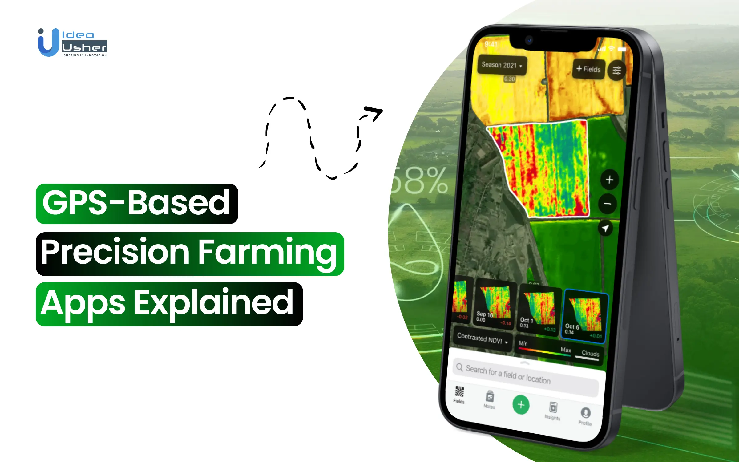
A GPS-based precision farming app is a digital tool that uses the Global Positioning System (GPS) to help farmers manage their fields accurately. Instead of seeing a farm as one large area, the app divides it into specific zones using real-time location data. This allows farmers to apply the right amount of seeds, water, fertilizer, or pesticide to each spot. This approach reduces waste and improves yields.
By using this app, farmers gain the ability to:
- Monitor field variability: They can identify which parts of the land are underperforming and require extra care, versus areas that are naturally more fertile.
- Automate equipment guidance: Tractors, sprayers, and harvesters can be connected to GPS maps, allowing them to operate with centimeter-level precision.
- Track farm operations over time: Each pass of the machinery creates a digital record, helping farmers understand how strategies like crop rotation, irrigation, or fertilization are working season after season.
- Reduce human error: Tasks like overlapping seed planting or over-spraying pesticides are minimized, cutting costs and ensuring consistent coverage.
- Make data-driven decisions: By combining GPS data with weather, soil, and drone imagery, farmers can plan irrigation schedules, predict yield, and respond faster to crop stress.
How GPS-Based Precision Farming Apps Work?
GPS precision farming apps use mapping, sensors, drones, and analytics to give farmers a clear view of their land. Instead of relying on general averages, decisions are made with specific accuracy. This makes sure resources are applied precisely where they are needed.

1. Field Mapping
The process begins with GPS-based digital field mapping, dividing farmland into precise zones based on soil, slope, elevation, and crop needs. Unlike traditional methods, this ensures no micro-zone is missed, allowing precise allocation of seeds, fertilizers, and water.
2. Data Collection with Sensors
Soil and environmental sensors are central to these apps. They monitor moisture, pH, nutrients, and climate in real time, helping farmers avoid blanket practices. This precision reduces over-irrigation and chemicals, ensuring consistent soil health and sustainability.
3. Crop Monitoring with Drones
High-resolution aerial imaging improves field visibility. Drones with multispectral and thermal sensors detect early stress, pests, and nutrient gaps. Unlike manual inspections, this bird’s-eye view enables scalable monitoring of hundreds of acres in minutes, reducing yield loss risks.
4. Integration with Analytics Platforms
All data feeds into AI analytics platforms, transforming raw inputs into recommendations for irrigation, fertilization, and pest control. Using GPS mapping and predictive models, these apps enable farmers to make decisions that reduce costs and boost productivity.
5. Machinery Guidance and Automation
The final stage involves connecting GPS-enabled machinery like tractors and sprayers, which follow automated GPS paths to avoid overlaps, reduce fuel waste, and ensure even coverage. This accuracy improves efficiency, cuts costs, and helps farms scale easily.
Why You Should Invest in Launching a GPS-Based Precision Farming App?
The global precision agriculture market size was valued at USD 9.32 billion in 2024 and is estimated to reach USD 21.47 billion by 2033, exhibiting a CAGR of 9.66% from 2025 to 2033. This growth is driven by the increasing adoption of GPS, IoT, AI, and data-driven solutions that enhance crop yields, reduce resource wastage, and improve farm efficiency.

MapMyCrop, an agritech startup, recently raised USD 1.8 million in seed funding led by YourNest Venture Capital. The platform leverages GPS, satellite imagery, and AI-driven analytics to provide precision insights for farmers, demonstrating strong investor appetite for GPS-powered farming solutions.
CropIn, a leading precision agriculture company, secured USD 20 million in a Series C round led by ABC World Asia. The platform integrates GPS, farm data, and predictive analytics, impacting millions of acres and reinforcing the scalability of precision farming apps.
Taranis, a precision farming intelligence startup, has raised over USD 20 million to scale its GPS and AI-powered crop monitoring solutions. Its growth showcases the rising global demand for advanced farm intelligence tools.
The precision agriculture industry is changing how we produce food, use resources, and focus on sustainability. Investing in a GPS-based precision farming app is a smart choice that puts businesses at the forefront of this shift in agriculture. With increasing market demand, strong interest from investors, and technology that can grow, GPS-powered solutions offer significant opportunities for growth, impact, and new ideas.

How GPS Technology Transforms Farming Operations?
The GPS precision farming app is transforming agriculture by enabling farmers to operate with unmatched accuracy. From planting to harvesting, every stage becomes more efficient, data-driven, and resource-conscious with GPS integration.
1. Precision Planting and Seeding
GPS ensures centimeter-level planting accuracy, allowing optimal crop spacing and depth. Farmers can target planting zones based on soil fertility and moisture, reducing seed waste, improving germination rates, and maximizing overall yield.
2. Optimized Fertilization & Chemical Application
With GPS mapping and variable-rate application, fertilizers, pesticides, and herbicides are applied only where needed. This lowers input costs, prevents soil nutrient imbalance, and enhances long-term environmental sustainability in farming practices.
3. Efficient Irrigation Management
By combining GPS with soil moisture sensors, irrigation systems deliver water precisely to dry zones. This reduces water wastage, minimizes pumping costs, and ensures crops receive moisture based on actual field conditions.
4. Automated Guidance for Farm Equipment
GPS-enabled tractors, sprayers, and harvesters follow exact paths, eliminating overlaps or missed areas. This improves efficiency, reduces fuel consumption, and minimizes soil compaction caused by repeated unnecessary machinery passes across farmland.
5. Yield Monitoring & Field Analysis
GPS-guided harvesters record real-time yield data, creating digital maps of productivity. These insights allow farmers to refine strategies, improve soil health, and plan effective crop rotations for sustainable productivity.
6. Risk Management and Planning
GPS enables hyper-local weather monitoring, detecting risks like frost, drought, or pests in specific zones. Farmers can act proactively, reducing potential losses and strengthening long-term strategic planning efforts.
7. Data-Driven Decision Making
By integrating GPS with drone imagery, soil sensors, and AI analytics, farmers gain comprehensive field visibility. Decisions on planting, inputs, and harvesting become precise, reliable, and based entirely on actionable data.
Key Features of GPS-Based Precision Farming Apps
GPS precision farming app solutions are significant because they bring together mapping, automation, and analytics in one system. These features help farmers work more efficiently, cut down on waste, and reach higher yields with precise control.

1. Geo-Zoned Field Mapping
Farmers can divide land into micro-areas using GPS-based zoning based on soil quality, elevation, and crop requirements. This allows resources like fertilizers and seeds to be applied only where necessary, preventing overuse and optimizing yields across every section.
2. GPS-Guided Machinery Control
Equipment like automated tractors, planters, and sprayers follow precisely mapped routes during planting, spraying, or harvesting. This eliminates overlaps and skips, reduces fuel waste, and ensures uniform crop coverage, even in irregularly shaped fields that are difficult to manage.
3. Variable Rate Application (VRA) Control
This feature adjusts input levels according to zone-specific soil and crop conditions. For instance, nutrient-poor sections receive higher fertilizer rates, while fertile areas require less, ensuring resource efficiency and consistent plant health across varied zones of farmland.
4. Soil & Crop Health Layer Integration
The app overlays sensor and drone data directly on GPS maps, creating visual health layers. Farmers can tap any zone to view moisture, nutrient, or pest insights, enabling quick, targeted interventions rather than blanket treatments.
5. Automated Irrigation Scheduling
By combining GPS mapping with soil moisture data, the app generates zone-specific irrigation schedules. This ensures water is directed precisely where needed, preventing overwatering or drought stress, while improving both soil health and long-term water sustainability.
6. Path Optimization for Field Operations
GPS algorithms calculate the most efficient routes for tractors and harvesters. This saves operational time, reduces fuel consumption, and prevents unnecessary soil compaction, preserving field health and maximizing machinery productivity during high-demand farming periods.
7. Harvest Yield Mapping
As harvesters operate, yield data is linked with GPS coordinates, producing detailed yield distribution maps. These maps highlight productive and underperforming areas, helping farmers refine strategies, adjust seeding densities, and plan resource allocation for upcoming seasons.
8. Weather & GPS-Based Alerts
Hyperlocal alerts tied to exact GPS zones notify farmers of frost risks, rainfall forecasts, or pest outbreaks. This location-specific accuracy ensures timely responses, unlike regional forecasts, which often miss the micro-variations within large farmlands.

Development Process of GPS-Based Precision Farming Apps
Developing a GPS precision farming app involves combining agricultural needs with new technologies. Our approach centers on creating user-friendly applications that turn raw geospatial data into useful insights for managing farms effectively.

1. Consultation
We begin with a detailed consultation with you to understand your business goals, objectives and define use cases of your farming app such as fertilizer management, yield monitoring, or equipment guidance. This ensures our GPS precision farming app solves specific farming challenges instead of being a generic digital solution.
2. System Architecture
Our developers design a scalable system architecture capable of handling continuous GPS signals, sensor inputs, and real-time field data. We select backend frameworks, mobile technologies, and databases that ensure performance, smooth equipment integration, and adaptability for both small farms and enterprises.
3. Geospatial Data Handling & Field Mapping Engine
We integrate GIS libraries like Mapbox or Leaflet to enable precise digital field mapping. Farmers can draw or import layouts, divide them into zones, and manage irrigation, fertilization, and planting individually, ensuring no resource is wasted across their farmland.
4. GPS Integration & Real-Time Location Tracking
Our developers make sure that the app can connect with RTK-GPS-enabled equipment such as tractors, drones, or harvesters using APIs and data protocols. This delivers centimeter-level accuracy for planting, spraying, and harvesting, helping farmers achieve precise real-time tracking without additional costly hardware.
5. Sensor & Drone Data Integration
Our app integrates with soil sensors, drones, and weather stations via APIs and IoT protocols like MQTT. This enables zone-specific insights such as dry patches requiring irrigation or pest-affected areas needing targeted interventions, maximizing efficiency across farming operations.
6. AI/ML Analytics Layer
We implement AI and machine learning models to analyze GPS, sensor, and drone data. This layer predicts yields, detects stress, and recommends zone-wise inputs, transforming raw geospatial information into trusted insights farmers can use for immediate decision-making.
7. UX Design for Farmers
Our design team creates intuitive interfaces with features like offline accessibility, voice commands, touch-based field drawing, and color-coded maps. This ensures the GPS precision farming app remains practical and usable even in rural areas with limited connectivity.
8. Testing in Controlled & Real-Field Conditions
We validate the app first in controlled simulations and then test with real GPS-enabled equipment in actual fields. This ensures reliability across varying terrains, weather conditions, and soil environments before the app is fully deployed to farmers.
9. Deployment & Cloud Integration
We deploy the app on cloud platforms such as AWS IoT or Azure IoT Hub, enabling secure data storage and real-time syncing. To support farms with poor internet connectivity, we also integrate edge computing for local GPS data processing.
10. Maintenance & Scalability
Our team ensures continuous updates, bug fixes, and scalability enhancements to keep the app compatible with evolving GPS equipment, drone APIs, and IoT devices. This guarantees long-term relevance for both small-scale farmers and large agricultural enterprises.
Cost Breakdown of GPS-Based Precision Farming App Development
Developing a GPS precision farming app requires multiple stages, each contributing to performance, accuracy, and scalability. Below is a structured cost breakdown that shows how the budget is distributed across development phases.
| Development Phase | Estimated Cost | Description |
| Consultation | $5,000 – $8,000 | Understanding farmer and agribusiness needs, defining use cases, and aligning features with real-world challenges. |
| System Architecture | $7,000 – $12,000 | Designing scalable architecture, selecting backend, database, and mobile frameworks for real-time GPS data handling. |
| Geospatial Data Handling & Mapping Engine | $8,000 – $14,000 | Integrating GIS libraries to process field layouts, boundaries, and zoning for accurate farm management. |
| GPS Integration & Real-Time Tracking | $12,000 – $20,000 | Enabling centimeter-level accuracy by integrating with RTK-GPS farm equipment, drones, and mobile devices. |
| Sensor & Drone Data Integration | $14,000 – $25,000 | Connecting soil sensors, weather stations, and drones via APIs for consolidated insights. |
| AI/ML Analytics Layer | $15,000 – $28,000 | Building AI models to analyze geospatial data for predictions, stress detection, and yield optimization. |
| UX Design for Farmers | $5,000 – $9,000 | Designing simple interfaces with offline support, voice commands, and intuitive maps. |
| Testing in Controlled & Real Fields | $7,000 – $12,000 | Validating app accuracy with simulated datasets and real-world GPS equipment across diverse conditions. |
| Deployment & Cloud Integration | $6,000 – $12,000 | Setting up secure, scalable infrastructure on AWS, Azure, or GCP with possible edge computing. |
| Maintenance & Continuous Updates | $4,000 – $12,000 | Ensuring compatibility with new devices, ongoing improvements, and long-term scalability support. |
Total Estimated Cost: $60,000 – $128,000
Note: The cost of developing a GPS precision farming app depends on features, integrations, and scalability requirements. Consult with IdeaUsher for accurate estimates and tailored development strategies to align the app with specific business goals.

Tech Stacks of GPS-Based Precision Farming App
Building a GPS precision farming app requires the right combination of technologies to handle geospatial data, ensure real-time tracking, and integrate IoT devices. The tech stack must be reliable, scalable, and tailored to the needs of precision agriculture.
1. Frontend Development
The frontend is the farmer’s main interaction point, so it must be simple, intuitive, and responsive. Since many users may have limited digital exposure, the design should prioritize usability, offline access, and multi-language support.
- Flutter / React Native: Enables cross-platform mobile app development, ensuring farmers can use the app on both Android and iOS devices with a single codebase.
- GIS Libraries (Mapbox, Leaflet, OpenLayers): Provide interactive field maps where farmers can view zones, soil data, and GPS-guided equipment routes in real-time.
2. Backend Development
The backend acts as the processing hub for GPS signals, field data, and analytics. It must be scalable enough to handle data from thousands of sensors and fast enough to provide real-time recommendations.
- Node.js / Django: Robust frameworks for building APIs and managing data-heavy workflows. They allow seamless integration between the app, GPS-enabled equipment, and external data sources like weather APIs.
- GraphQL / REST APIs: Facilitate smooth data exchange between frontend, backend, and third-party integrations such as drones or IoT devices.
3. Database Layer
Precision farming apps deal with both structured (sensor readings, yield data) and unstructured data (drone imagery, satellite layers). A hybrid database approach works best.
- PostgreSQL (with PostGIS extension): Ideal for handling geospatial data such as field boundaries, soil maps, and GPS coordinates.
- MongoDB: Stores unstructured datasets like drone imagery or historical crop health data for flexible querying and analysis.
4. GPS & Geospatial Integration
High-accuracy GPS processing is the backbone of precision farming. The app must be capable of syncing with existing GPS-enabled machinery.
- RTK-GPS Support: Ensures centimeter-level accuracy for planting, spraying, and harvesting.
- Geospatial APIs (Google Maps API, OpenStreetMap, ESRI ArcGIS): Provide mapping layers and real-time tracking for farm operations.
5. Sensor & Drone APIs
Modern farms already deploy IoT sensors and drones. The app integrates with these external systems to bring data into one place.
- DJI Mobile SDK / DroneDeploy API / Pix4D: Enable integration with drones for aerial imaging and crop monitoring.
- MQTT / LoRaWAN Protocols: Allow seamless communication with IoT soil sensors, weather stations, and irrigation controllers.
6. AI & Machine Learning
AI is essential for turning raw GPS and sensor data into actionable insights.
- TensorFlow / PyTorch: Used for crop stress detection, yield prediction, and anomaly identification.
- Computer Vision Models: Process drone and satellite imagery to detect pests, diseases, or nutrient deficiencies in specific field zones.
7. Cloud & IoT Infrastructure
Scalability is key since data comes from multiple sources across wide areas. Cloud platforms allow real-time data syncing and storage.
- AWS IoT / Azure IoT Hub / Google Cloud IoT: Handle device connectivity, sensor data ingestion, and cloud-based analytics.
- Edge Computing Support: Ensures GPS data and sensor insights can still be processed locally in areas with poor internet connectivity.
Challenges & How to Overcome Them
Building a GPS-based precision farming app requires overcoming technical and operational barriers that directly affect performance, usability, and adoption. Below are the major challenges and how our development approach addresses them effectively.
1. Handling Large Geospatial Data
Challenge: GPS-based apps generate massive datasets like field maps, drone images, and sensor readings. Processing and visualizing this geospatial information in real-time without delays is a critical challenge for precision farming app performance.
Solution: We use cloud-based storage with auto-scaling to handle data spikes, apply spatial indexing for efficient geospatial queries, and leverage edge computing for local pre-processing before syncing, ensuring smooth and reliable data performance.
2. Integration with Diverse Equipment
Challenge: Modern farms use different GPS-enabled tractors, drones, and IoT sensors, each with unique APIs and data formats. Smooth integration without hardware modifications is a challenge in precision farming app development.
Solution: Our developers build a modular integration layer that standardizes data across devices. We support popular APIs like the DJI SDK first and use adapter patterns for easily adding compatibility with new farm equipment.
3. Accurate GPS Data Interpretation
Challenge: GPS accuracy can vary due to signal interference, weather conditions, or device limitations, making tasks like planting, spraying, or irrigation less reliable and causing unnecessary resource wastage.
Solution: We integrate RTK and DGPS correction methods for centimeter-level accuracy, display confidence levels of GPS readings in-app, and cross-verify GPS data with sensor inputs to deliver dependable results.
4. Connectivity Issues in Remote Farms
Challenge: Remote farmlands often face poor internet connectivity, making it difficult to sync real-time GPS, drone, and sensor data effectively within a precision farming app.
Solution: We design offline-first features for local data storage, use MQTT protocols for lightweight communication, and implement local caching of mapping layers so the app works seamlessly without constant internet access.
Conclusion
GPS-based precision farming apps are changing how farmers manage their fields. They offer exact location data for planting, irrigation, and harvesting. With detailed mapping and real-time monitoring, farmers can reduce waste, use their land more effectively, and produce higher yields. These apps also help with decision-making by providing insights into soil differences and crop performance. As agriculture relies more on data, GPS technology keeps farming practices efficient and sustainable. Using these tools enables farmers to grow over time, use resources wisely, and build resilience in their operations.
Why Choose IdeaUsher for GPS Farming App Development?
At IdeaUsher, we create GPS-enabled precision farming apps that empower farmers with accurate mapping, automated guidance, and real-time monitoring. Our solutions are built to reduce resource wastage, enhance crop yields, and support sustainable agricultural practices.
Why Work with Us?
- Precision Expertise: We combine GPS technology with AI and IoT for highly efficient farm management solutions
- Custom Development: Our team builds applications tailored to specific agricultural operations and crop cycles.
- Proven AgriTech Projects: From smart farming platforms to precision tools, we have delivered solutions that drive measurable results.
- Scalable and Reliable: We ensure apps remain adaptable as farms expand and technology advances.
Explore our portfolio to see how we designed solutions that revolutionize farming with GPS-driven insights.
Book a date for a detailed meeting to learn how we can help you build a GPS-based farming app that drives precision, sustainability, and measurable growth in your agricultural operations.


FAQs
GPS enables accurate mapping of fields, guiding machinery during planting, irrigation, and harvesting. This precision reduces overlaps and resource wastage while maximizing efficiency, ensuring farmers achieve consistent results and improved crop yield across large-scale operations.
These apps provide real-time field mapping, automated machinery guidance, soil variability tracking, and route optimization. Such features enhance farm management by ensuring precise input placement and reducing errors in day-to-day agricultural operations.
By ensuring accurate placement of seeds, fertilizers, and pesticides, GPS technology reduces unnecessary usage and minimizes wastage. This leads to significant cost savings while also promoting better crop management and higher returns for farmers.
Yes, GPS-based farming apps support sustainability by optimizing resource use, reducing chemical runoff, and promoting efficient land management. They help farmers adopt eco-friendly practices while maintaining productivity, aligning agriculture with long-term environmental goals.


