
Geospatial AI is a revolutionary technology that combines artificial intelligence with location-based information. By analyzing vast amounts of spatial data, geospatial AI empowers us to make smarter decisions.
From predicting traffic patterns to optimizing crop yields, this powerful technology is transforming industries and shaping the future.
The integration of AI with geospatial data is driving significant growth in the market, fueled by its potential for real-time analysis, predictive modeling, and unparalleled spatial recognition.
In this blog, we’ll look at how geospatial AI goes beyond simple innovation to become an influential player in analytics.
Geospatial AI Key Market Takeaway
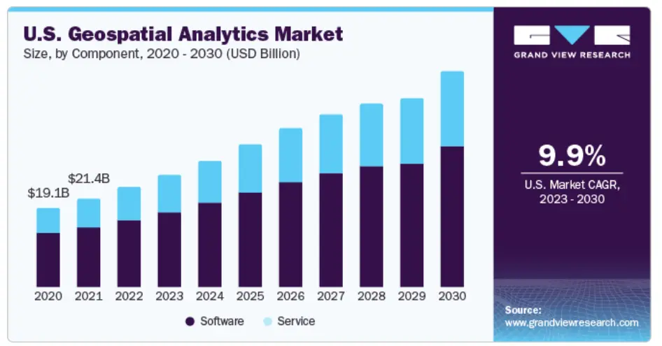
Source: GrandViewResearch
The growing Geospatial AI market does indeed signal a significant business opportunity for several reasons:
- Increasing Demand for Insights from Location Data: Businesses across industries are recognizing the value of location data in understanding customer behavior, optimizing operations, and making data-driven decisions. Geospatial AI helps extract meaningful insights from this data, making it more actionable.
- Rapid Technological Advancements: Advancements in AI, machine learning, and data processing capabilities are making geospatial analysis faster which fuels market growth and opens doors for new applications.
- Addressing Global Challenges: Geospatial with AI can play a crucial role in tackling challenges like climate change, resource management, and disaster response. Companies that develop solutions in these areas can address critical needs and capture a significant market share.
- Unexplored Applications: The potential geospatial applications with the help of AI are constantly emerging. From precision agriculture to autonomous vehicles, there’s a vast potential for innovation and new business models.
What is Geospatial AI?
Geospatial AI is a subfield of artificial intelligence that uses geographic data and AI’s analytical capabilities to deliver insights and solutions to a variety of businesses.
From optimizing logistics to revolutionizing urban planning, GeoAI offers a range of benefits. Businesses can make smarter decisions and gain a significant edge in today’s data-driven world. This integration unlocks the true potential of spatial data, empowering businesses to thrive in a competitive digital landscape.
Through the use of GeoAI, businesses may successfully negotiate the complexities of today’s data-centric landscape and position themselves for success in a very competitive digital ecosystem.
Top 6 Benefits of Using Geospatial AI
The way we get insights from geographical data is being revolutionized by the development of geospatial AI. This cutting-edge technology provides a potent toolset for addressing difficult problems in a variety of fields, allowing for accurate decision-making and predictive analysis. Let’s examine the main advantages of geospatial AI in more detail.
1. Improved Efficiency and Reduced Costs
Geospatial AI helps businesses by speeding up the analysis of data about locations. This technology automates handling giant sets of geographic information, so businesses get insights faster, which is important for making decisions right away.
Using AI for geospatial data analysis saves businesses a lot of expenses on their operations. Companies can benefit from spending less on labor and managing resources better.
2. Advanced Predictive Abilities
From protecting the environment to planning cities, geospatial AI helps us use resources wisely. By finding patterns in geographic data, potential problems and opportunities can be identified before they even happen.
Think of it as a heads-up for better decision-making. With this warning, you can make strategic plans, manage risks, and invest your money more effectively.
3. Maximized Decision-Making Precision
Careful data analysis is essential for making more intelligent decisions. Organizations can more accurately predict outcomes with the use of spatial data insights. For sectors such as urban planning and logistics, this accuracy is crucial. This procedure is greatly enhanced by the use of AI in geospatial analytics, which makes it possible to handle complicated information quickly.
As a result, businesses may decide with knowledge at a never-before-seen speed. Having this agility is essential to keeping a competitive advantage. Moreover, it promotes sustainable growth by optimally allocating resources.
4. Real-Time Spatial Insights
The precision and speed of geospatial AI enable better resource allocation, minimizing waste and reducing costs. It empowers businesses to adapt to market fluctuations rapidly, ensuring a competitive advantage where real-time insights contribute to the development of smarter and more informed strategic plans across various industries. Therefore, integrating geospatial AI into daily operations demonstrably yields substantial benefits.
5. Enhanced Service Accessibility and Equity
By analyzing massive amounts of location-based data, geospatial AI sheds light on areas that need the most help and allows for fairer resource allocation and a more balanced distribution of vital services like healthcare and education.
Geospatial AI helps us move towards a more inclusive society by supporting strategies for universal access. It’s like a map that guides us in delivering services directly to underserved populations. This ensures everyone has what they need.
6. Public Safety and Security
Geospatial AI can pinpoint potential hazards, ranging from natural disasters to artificial threats. AI empowers improved emergency response strategies by predicting where resources will be most crucial. Visualizing complex data geographically grants law enforcement a significant advantage in hazard prevention and investigation efforts.
Use Cases Of Geospatial Analytics
Geospatial analytics is fundamentally changing how we perceive and engage with the world around us. From urban planning to environmental monitoring, here’s a closer look at some of the key use cases for geospatial analytics:
1. Urban Development Optimization
Geospatial AI can predict population growth, allowing for efficient resource allocation and proactive infrastructure development. This technology can pinpoint optimal locations for public services, maximizing accessibility for residents. Additionally, AI can identify underutilized spaces demanding redevelopment. By offering a comprehensive understanding of urban dynamics, AI holds the key to creating more efficient cities of the future.
2. Disease Tracking and Response
Geospatial AI can pinpoint hotspots and identify trends by creating real-time maps of disease spread. The technology allows for continuous monitoring of public health measures. By analyzing emerging data, adjustments can be made to optimize strategies. This approach yields a deeper understanding of how diseases propagate geographically.
3. Environmental Surveillance
By analyzing vast amounts of satellite imagery, geospatial AI can pinpoint areas of environmental concern with exceptional speed. This enables us to take timely interventions to mitigate negative consequences for natural habitats.
Leveraging the power of Geospatial Artificial Intelligence, environmental monitoring has become a powerful tool for safeguarding our planet’s ecosystems. This technology excels at accurately mapping changes in vegetation, water bodies, and urban sprawl.
4. Transportation And Logistics
Artificial intelligence (AI) applied to geospatial analysis is revolutionizing transportation and logistics. This technology optimizes route planning, leading to significant time savings. Traffic predictions further empower logistics companies with the ability to reroute intelligently.
The transformative power of AI-powered predictive geospatial intelligence solutions extends beyond just routes. It enhances supply chain efficiency by pinpointing bottlenecks for swift resolution. Fleet management also undergoes a major overhaul through continuous vehicle health monitoring and the creation of optimized maintenance schedules.
5. Renewable Energy Site Selection
Leveraging geospatial AI can streamline the siting process for renewable energy projects by precisely evaluating wind and solar resources. This innovative technology pinpoints the ideal locations for wind turbines and solar panels, ensuring maximum energy output.
Geospatial AI facilitates the analysis of land use compatibility, ensuring that renewable energy projects coexist harmoniously with the surrounding environment. Additionally, this approach leads to more efficient and effective infrastructure planning, potentially reducing project development timelines.
6. Agricultural Management
AI can predict and prevent pest outbreaks before they cause significant damage. This can significantly enhance sustainable farming practices, potentially leading to increased agricultural productivity.
Strategic planning guided by AI-powered geospatial analysis can minimize environmental impact. Crop rotation strategies can be refined to improve soil fertility, leading to healthier crops. Fertilizer applications can be strategically managed, reducing waste and environmental pollution. Water resources can be conserved more effectively through data-driven insights.
7. Disaster Response Enhancement
Geospatial analytics provide crucial guidance for efficient search and rescue operations. Additionally, geospatial analytics streamlines the identification of safe evacuation routes and efficient aid delivery paths.
Accurate damage assessments based on geospatial data expedite recovery efforts, accelerating the rebuilding process and playing a vital role in the swift restoration of international assistance.
8. Retail Strategy Optimization
GeoAI empowers retailers to make smarter, data-driven decisions across all aspects of their operations. Retail businesses can unlock insights for strategic decision-making.
This cutting-edge technology can pinpoint ideal locations for new stores by analyzing consumer demographics and deciphering behavior patterns. GeoAI empowers retailers to gain a deeper understanding of market trends.
The benefits of geospatial analytics extend beyond the store walls, optimizing supply chain management by identifying the most efficient routes, ultimately reducing delivery times and costs.
9. Satellite Imagery Utilization
The integration of artificial intelligence and geospatial analytics is revolutionizing the field of satellite imagery and remote sensing. This powerful combination enhances environmental monitoring by enabling the detection of subtle changes in land use and vegetation. It also allows for more precise weather forecasting, ultimately improving our ability to prepare for and respond to disasters.
Future Trends Of Geospatial Artificial Intelligence
GeoAI has the potential to revolutionize the way we analyze data and make decisions. Here’s a look at some of the anticipated advancements we can expect to see from this integration:
1. Big Data and Cloud Computing
Cloud platforms provide users with on-demand, scalable resources, allowing them to tackle complex computations without limitations imposed by traditional infrastructure. Big data analytics, fueled by AI, can unearth hidden patterns and trends within geospatial information.
2. Deeper understanding of complex datasets
GeoAI will allow us to extract more meaningful insights from complex geospatial data sets. This will enable us to identify patterns and relationships that would be difficult to see with traditional methods.
3. Improved predictive modeling
GeoAI can be used to develop more accurate models that can predict future events. This could be used for a variety of applications, such as predicting crop yields, forecasting traffic patterns, and assessing the risk of natural disasters.
4. Automated data analysis
GeoAI can automate many of the tasks involved in data analysis, such as data cleaning and feature extraction. This will free up human analysts to focus on more complex tasks.
Challenges To Consider For Geospatial AI
While GeoAI has enormous promise, it also presents limitations. Data privacy and security are key problems. The accuracy of AI forecasts is strongly dependent on the quality of data obtained, which can be challenging to maintain given the vastness and diversity of geographical information. Here are some challenges to consider:
1. Data Volume and Complexity
Geospatial data, encompassing everything from satellite imagery to GPS coordinates, is exploding in volume. This abundance presents a challenge: efficiently processing and analyzing vast datasets requires significant computational power and sophisticated algorithms.
2. Data Quality and Bias
The quality and consistency of geospatial data can vary greatly. Data may contain errors or missing information. Satellite imagery might be biased towards certain weather conditions. Geospatial AI models must be robust enough to handle these imperfections and mitigate the influence of biases to ensure accurate and reliable results.
3. Privacy Concerns
Geospatial data often contains sensitive information about people and places, and as geospatial AI applications become more sophisticated, concerns regarding privacy rise. Striking a balance between leveraging the power of geospatial data and protecting individual privacy is essential. Developing anonymization techniques and robust data governance frameworks will be crucial for the responsible development of geospatial AI.
4. Ethical Considerations
The use of geospatial AI raises a number of ethical considerations. Algorithmic bias can lead to discriminatory outcomes, and the ability to track and monitor individuals through geospatial data can have privacy implications. Developing ethical frameworks for geospatial AI development and deployment is crucial to ensure responsible use of this powerful technology.
5. Interoperability and Standardization
Geospatial data comes in various formats and standards. This lack of uniformity can hinder the integration and exchange of data between different platforms and applications. Standardizing geospatial data formats and fostering interoperability will be vital for facilitating the seamless use of geospatial data in AI applications.
6. Accessibility and Skills Gap
Geospatial AI requires specialized skills and knowledge, from data science to geographic information systems (GIS). A lack of accessibility to these skills and the high cost of geospatial data can create a barrier for many organizations and individuals who might benefit from this technology. Efforts to bridge this skills gap and develop user-friendly tools are necessary to democratize access to geospatial AI.
Conclusion
Geospatial AI offers a powerful combination of geographic data and artificial intelligence, unlocking a new era of data-driven decision-making for businesses. This technology streamlines operations and delivers real-time insights.
However, integrating and managing complex geospatial data requires expertise. Partnering with an AI development company can bridge this gap. They can transform your geographic data into actionable intelligence, empowering your business to navigate an increasingly complex world.
Unlock The True Potential Of Geospatial AI or Other AI Projects with Idea Usher
Our team of expert developers with over 10+ years of experience is dedicated to advancing predictive modeling across a wide range of AI applications, encompassing everything from urban development to environmental preservation. We design custom solutions to optimize logistics, refine response strategies in critical situations, and promote sustainable practices.
By leveraging our proven track record in delivering top-tier AI development services, we equip our clients with a significant competitive advantage. This advantage empowers them to make smarter, data-driven decisions.
Partner with Idea Usher to navigate the complexities of spatial data and unlock its potential, transforming it into actionable intelligence that fuels your success.


FAQs
Q. What is AI for geospatial analysis?
A. AI for geospatial analysis, also known as GeoAI, is a powerful combination of Geographic Information Systems (GIS) and artificial intelligence techniques like machine learning and deep learning. It analyzes massive amounts of location-based data to extract hidden patterns and unlock a deeper understanding of the real world.
Q. What are the three main uses of AI in GIS?
A. There are three main ways AI is used in GIS. First, AI can automate tasks like classifying land cover in satellite images, saving time and improving accuracy. Second, AI can be used to find patterns in geospatial data that humans might miss, like identifying areas at risk of flooding or disease outbreaks. Finally, AI can be used to predict future events, such as traffic congestion or crop yields, allowing businesses and governments to make better decisions.
Q. How can businesses benefit from implementing geospatial AI solutions?
A. Businesses can benefit greatly from implementing GeoAI solutions. By gaining a deeper understanding of their locations and customer base, businesses can optimize logistics, target marketing campaigns more effectively, and identify new market opportunities. GeoAI can also be used to assess risks and improve resource allocation, leading to significant cost savings.