In today’s fast-paced world, navigation apps have become an integral part of our lives, guiding us through unfamiliar streets, helping us discover new places, and optimizing our travel experiences. But what if we could take navigation to the next level? Augmented Reality (AR) GPS apps are revolutionizing the way we navigate and interact with our surroundings. The integration of Augmented Reality (AR) and Global Positioning System (GPS) technologies has paved the way for a groundbreaking innovation: AR GPS apps. These cutting-edge applications offer a unique and captivating way to navigate and interact with the world around us. For entrepreneurs and customers who aspire to create their own AR GPS app, understanding the development process is essential to harness the full potential of this emerging technology.
Therefore, this blog aims to guide entrepreneurs and customers through the process of building an AR GPS app, unlocking the potential for innovation, user engagement, and revenue generation. We will delve into the technical aspects, best practices, and critical features that make an AR GPS app successful. From designing the user interface to integrating GPS functionality and developing AR overlays, we will explore the step-by-step process to turn your vision into a reality.
What is an Augmented Reality GPS App?

An augmented reality (AR) GPS app is a mobile application that combines GPS (Global Positioning System) technology with augmented reality overlays to provide users with real-time location-based information and visual cues. Unlike traditional GPS apps that display information on a map or in a list format, AR GPS apps use the device’s camera and sensors to overlay digital content onto the real-world view, enhancing the user’s perception and understanding of their surroundings.
Global Market and Statistics
- The market for mobile augmented reality (AR) is projected to experience significant growth, with a predicted size of $184.61 billion by 2030, exhibiting a remarkable compound annual growth rate (CAGR) of 31.40% from 2021 to 2030, according to Allied Market Research.
- AR GPS apps play a substantial role in driving this growth, as they offer a unique fusion of location-based services and augmented reality experiences, enhancing navigation, exploration, and user engagement.
- AR GPS apps leverage the power of GPS technology to provide accurate positioning and real-time location updates, enabling users to navigate their surroundings effectively.
- By integrating augmented reality overlays onto the live camera view, these apps superimpose digital information, such as points of interest, directions, or contextual data, onto the real-world environment, enhancing the user’s perception and interaction with their surroundings.
- The increasing adoption of AR GPS apps is driven by their ability to provide intuitive and immersive navigation experiences, catering to various industries, including tourism, gaming, retail, and education.
How do Augmented Reality GPS Apps Work?
AR GPS apps combine the functionalities of Augmented Reality (AR) and Global Positioning System (GPS) technologies to create a unique and immersive navigation experience. Here’s a breakdown of how AR GPS apps work:
1. GPS Location Tracking
The app uses GPS or GNSS (Global Navigation Satellite System) technology to track the user’s real-time location.
GPS receivers in smartphones or other devices receive signals from multiple satellites to calculate the user’s precise coordinates (latitude and longitude).
2. Real-Time Positioning
The app continuously updates the user’s location, allowing for accurate positioning within the AR environment
GPS data is utilized to determine the user’s position relative to the physical world and nearby points of interest (POIs).
3. Augmented Reality Overlay
The app utilizes the device’s camera to provide a live view of the user’s surroundings.
AR overlays, which can include digital images, text, 3D models, or directional indicators, are superimposed onto the camera view in real-time.
4. Marker Detection (Optional)
Some AR GPS apps employ marker-based AR, where specific visual markers or QR codes act as triggers for AR content.
These markers are detected by the app’s camera, enabling the precise placement of AR elements within the user’s environment.
5. POI Information
The app retrieves relevant data from a database or external sources based on the user’s location.
Points of interest (POIs) such as landmarks, restaurants, or attractions are identified and displayed as AR overlays, providing additional information, ratings, reviews, or directions.
6. User Interaction
Users can interact with AR elements, such as tapping on a POI to access detailed information, selecting a destination for navigation, or leaving reviews and comments.
Gesture-based interactions, like swiping or pinching, may also be incorporated to manipulate or navigate AR content.
7. Navigation Guidance
AR GPS apps offer real-time navigation guidance by overlaying directional indicators, arrows, or path markers onto the camera view.
Users receive visual cues and instructions overlaid on their surroundings, guiding them toward their desired destination.
8. Contextual Information
AR GPS apps can provide contextual information about the user’s environment, such as historical facts about landmarks or real-time information about nearby events, businesses, or transit options.
This information enhances the user’s understanding and engagement with their surroundings.
By combining GPS technology for accurate positioning and AR overlays for visual enhancements, AR GPS apps create a dynamic and immersive navigation experience. Users can explore their surroundings, discover points of interest, and receive real-time guidance through the seamless integration of the digital and physical worlds.
Critical Features of Augmented Reality GPS Apps

There are several critical features that make augmented reality GPS apps stand out, including accurate GPS tracking, real-time AR overlays, intuitive user interfaces, and interactive elements that enhance navigation and provide a seamless user experience. Let’s take a look at them:
1. Real-Time Location Tracking
Accurate and reliable tracking of the user’s location using GPS or GNSS technology, allowing for precise positioning and navigation within the AR environment.
2. Augmented Reality Overlays
Overlaying digital information, such as points of interest, directions, or contextual data, onto the real-world camera view to provide users with relevant and interactive information in real-time.
3. POI Discovery and Information
Displaying points of interest (POIs) in the user’s vicinity, providing details such as descriptions, ratings, reviews, opening hours, and contact information, enhancing the user’s ability to explore and discover nearby locations.
4. Navigation and Directions
Offering turn-by-turn navigation and route guidance through AR visual cues, arrows, or markers overlaid onto the camera view, assisting users in reaching their destinations efficiently.
5. Offline Mode
Allowing users to access previously downloaded maps, POI information, and navigation routes in areas with limited or no internet connectivity, ensuring uninterrupted functionality.
6. Social Interaction and Sharing
Enabling users to connect with friends or other app users, share location-based experiences, and discover recommended places or activities based on social connections or shared interests.
7. Customization and Personalization
Allowing users to customize the AR interface, preferences, and settings according to their preferences, such as choosing different AR styles, adjusting POI visibility, or setting navigation preferences.
8. Safety and Alerts
Providing safety features, such as alerts for dangerous areas, real-time traffic updates, or proximity warnings for potential hazards, ensuring user safety during navigation.
9. Offline Mapping and Geolocation Data
Including offline maps and geolocation data to reduce reliance on internet connectivity, improve performance, and enable users to explore remote or low-connectivity areas.
10. Integration with External Services
Integrating with external services, such as third-party APIs, to access additional data sources, such as weather information, public transportation schedules, or booking services, enhances the app’s functionality and user experience.
11. Gamification and Rewards
Incorporating gamified elements, challenges, achievements, or rewards to make the navigation experience more engaging, motivating users to explore and interact with their surroundings.
12. Compatibility and Platform Support
Developing the app for multiple platforms, such as iOS and Android, to reach a broader user base and ensure compatibility with different devices and operating systems.
These critical features contribute to the core functionality and user experience of AR GPS apps, delivering a seamless blend of augmented reality and location-based services for efficient navigation, information retrieval, and exploration.
Benefits of AR GPS apps over traditional GPS apps
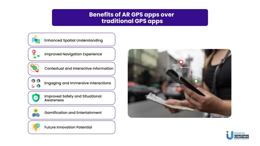
The significant benefits and advantages that AR GPS apps bring over traditional GPS apps, including real-time visual overlays, interactive features, and enhanced navigation experiences that revolutionize the way we interact with our surroundings, are listed below:
1. Enhanced Spatial Understanding
AR GPS apps provide users with a visual representation of their surroundings in real time. By overlaying digital information onto the camera view, users can better understand their location in relation to nearby points of interest, streets, and landmarks.
2. Improved Navigation Experience
Traditional GPS apps often rely on map-based interfaces, requiring users to switch between the map and the real world. AR GPS apps eliminate this disconnect by superimposing route guidance and directions directly onto the user’s view, making navigation more intuitive and seamless.
3. Contextual and Interactive Information
AR GPS apps offer contextual information about the user’s environment. By overlaying points of interest, reviews, ratings, and other relevant data, users can quickly access information without searching through lists or maps, leading to a more interactive and informative experience.
4. Engaging and Immersive Interactions
Augmented reality adds a layer of interactivity to the GPS experience. Users can physically move and explore their surroundings while experiencing digital elements overlaid in the real world. This engagement factor makes AR GPS apps more enjoyable and memorable.
5. Improved Safety and Situational Awareness
AR GPS apps allow users to keep their focus on the real world while receiving necessary information. By presenting data in an augmented reality format, users can maintain situational awareness, especially while navigating unfamiliar areas or busy streets.
6. Gamification and Entertainment
AR GPS apps have the potential to incorporate gamified elements, turning exploration and navigation into interactive and entertaining experiences. Users can engage in location-based games, challenges, or quests, making their journeys more exciting and enjoyable.
7. Future Innovation Potential
Augmented reality technology continues to evolve rapidly, enabling new possibilities for AR GPS apps. As AR hardware improves and new features emerge, such as wearable AR devices or integration with smart glasses, the potential for innovative and immersive experiences within AR GPS apps will expand further.
Overall, AR GPS apps leverage augmented reality technology to provide a more intuitive, interactive, and immersive navigation experience. They enhance spatial understanding, deliver contextual information, and open doors to creative and engaging interactions, making them a compelling choice for users seeking a dynamic and enriched GPS experience.
Revenue Generations Strategies for AR GPS Apps

AR GPS apps can employ various revenue-generation strategies to monetize their services. Here are some effective strategies:
1. Freemium Model
Offer a free version of the app with basic features and limited functionality and provide advanced features or additional content through in-app purchases or subscriptions. This allows users to experience the app before deciding to upgrade for enhanced capabilities.
2. In-App Advertising
Integrate targeted advertisements within the app, leveraging location-based data to provide relevant ads to users. Ad formats can include banner ads, interstitials, or sponsored AR overlays. Partnering with local businesses or relevant brands can be beneficial for targeted advertising.
3. Sponsored POIs and Promotions
Collaborate with businesses to feature sponsored points of interest (POIs) or promotions within the app. For example, restaurants or retail stores can pay for their locations to be highlighted as recommended options, offering discounts or exclusive deals to app users.
4. Premium Content or AR Experiences
Develop premium AR content or experiences, such as advanced AR navigation modes, interactive tours, or specialized AR overlays for specific industries. Users can purchase these premium offerings, enhancing their AR GPS experience with unique and valuable content.
5. Data Licensing and API Access
If your app collects and analyzes location data, you can explore licensing agreements with businesses or organizations that can benefit from access to that data for market research, urban planning, or other purposes. Additionally, you can provide API access to developers or companies looking to integrate location-based services into their own applications.
6. Partnerships and Affiliations
Forge partnerships with relevant service providers, such as transportation companies, tour operators, or travel agencies. By integrating their services into your app or offering referral programs, you can earn commissions or revenue sharing from bookings or transactions made through your app.
7. White Labeling and Enterprise Solutions
Offer white-label versions of your AR GPS app to other businesses or organizations, allowing them to customize and rebrand the app with their own branding and use it as part of their service offerings. This can include enterprise solutions for industries like logistics, field services, or asset management.
8. Analytics and Insights
Provide analytics and insights to businesses based on the aggregated location data collected by the app. This can include foot traffic analysis, user behavior patterns, or location-based trends, offering valuable insights to businesses for decision-making or marketing purposes.
9. Crowdsourcing and User Contributions
Allow users to contribute content, such as reviews, photos, or location updates, and implement premium features for users who actively contribute. You can also offer rewards or incentives for users who provide valuable data or participate in user-generated content campaigns.
10. Licensing Intellectual Property
If your app incorporates unique AR technologies, algorithms, or proprietary solutions, consider licensing your intellectual property to other developers, AR platforms, or device manufacturers.
It’s essential to choose revenue-generation strategies that align with your app’s target audience, user experience, and value proposition. A combination of multiple strategies can help diversify revenue streams and optimize monetization opportunities for your AR GPS app.
Top 6 Augmented Reality GPS Apps in the Market
Given below, are the top augmented reality GPS apps in the market that revolutionize navigation by blending real-time GPS data with augmented reality overlays:
1. AR Kit By Apple
- ARKit is Apple’s framework for creating AR experiences on iOS devices.
- It tracks device position and orientation using the camera and motion sensors.
- ARKit supports surface detection, 3D object integration, and realistic virtual interactions.
- It includes features like face tracking and collaborative AR experiences.
- With ARKit, developers can build immersive and interactive AR apps on iOS.
2. Google Maps AR
- Google Maps AR is an augmented reality feature integrated into the popular Google Maps app.
- It allows users to view real-time directions through their device’s camera, superimposing directional arrows and street names onto the live view.
- The app also provides information about nearby points of interest and businesses.
3. Wikitude
- Wikitude is an AR platform that provides developers with tools to create their own AR GPS apps.
- The platform enables the integration of GPS data with augmented reality overlays, allowing for location-based AR experiences.
- Wikitude offers features such as 3D object recognition, image recognition, and geolocation-based AR content.
4. ARCore By Google
- ARCore is Google’s framework for building AR experiences on Android devices.
- It uses the device’s camera and sensors to track the position and orientation in the real world.
- ARCore supports environmental understanding, allowing virtual objects to interact with surfaces and the surrounding environment.
- The framework provides features such as motion tracking, light estimation, and plane detection for accurate and realistic AR experiences.
- ARCore offers cloud anchors, enabling multi-user and collaborative AR experiences.
- It supports integration of 3D models, animations, and physics simulations into AR applications.
5. Blippar
- Blippar is an AR GPS app that offers a range of features, including visual search, navigation, and discovery.
- It allows users to scan their surroundings and receive information about landmarks, restaurants, and other points of interest through AR overlays.
- Blippar also offers gamified experiences and rewards for exploration.
6. Junaio
- Junaio is an AR browser app that incorporates GPS technology to provide location-based AR experiences.
- It offers features like POI discovery, AR content creation, and social sharing.
- Junaio allows users to explore their surroundings through the camera view and interact with AR content in real time.
7. Yelp
- While primarily known as a review and recommendation app, Yelp also incorporates AR features for navigation and exploration.
- Yelp’s AR functionality allows users to view ratings, reviews, and information about nearby businesses overlaid onto the real-world view.
- This provides an enhanced user experience for discovering new places and making informed decisions.
How to Develop an AR GPS App: Step-by-Step Guide

Below are the key development steps to guide you in building your own AR GPS app:
1. Define the App’s Objectives
- Clearly define the purpose of your app. Is it for navigation, exploration, tourism, gaming, or any other specific use case?
- Identify your target audience and their needs to ensure the app caters to their requirements.
- Determine the core functionalities your app should offer, such as POI discovery, navigation, social interactions, or gamification elements.
2. Select Development Tools and Technologies
- Choose a development platform suitable for building AR applications, such as Unity 3D, ARKit/ARCore, or Vuforia.
- Explore available AR frameworks and libraries compatible with your chosen platform.
- Decide on the GPS technology to utilize, such as GPS (Global Positioning System) or GNSS (Global Navigation Satellite System), based on the desired accuracy and coverage.
3. Design User Interface and User Experience (UI/UX)
- Create wireframes and design the user interface (UI) to ensure a seamless AR experience.
- Consider intuitive interactions and visual cues to guide users effectively within the AR environment.
- Design the information architecture and navigation flow, keeping the user experience (UX) smooth and efficient.
4. Technology Stack Required
| Technology | Purpose |
|---|---|
| Unity 3D | Cross-platform game engine and development platform |
| ARKit/ARCore | AR frameworks for iOS and Android respectively |
| Vuforia | AR platform for marker-based AR experiences |
| GPS/GNSS APIs | Access and retrieve real-time location data |
| Backend Infrastructure | Server infrastructure for data storage and management |
| RESTful APIs | Communication between app and backend services |
| Database (e.g., MySQL) | Store and retrieve app-related data |
| Authentication System | User authentication and authorization |
| Map Data Providers | Integration with services providing map and location data |
| UI/UX Design Tools | Design tools such as Sketch or Adobe XD for UI prototyping |
| Testing Frameworks | Tools for automated testing and debugging |
| Analytics Tools | Track and analyze user behavior and app performance |
| Version Control | Git or similar tools for version control and collaboration |
| Cloud Services | Cloud platforms for hosting, scaling, and deploying the app |
| Push Notifications | Push notification services to send alerts and updates to users |
| Payment Gateway | Integration with payment gateways for in-app purchases |
5. Gather and Prepare Data
- Acquire GPS data sources or integrate with location data providers that offer accurate and up-to-date geographical information.
- Collect relevant data about points of interest (POIs), such as their coordinates, descriptions, images, ratings, and reviews.
- Organize and structure the data in a format suitable for efficient retrieval and display within the app.
6. Implement GPS Functionality
- Integrate GPS or GNSS APIs provided by your chosen development platform or external location service providers.
- Retrieve the user’s real-time location updates to accurately position them within the AR environment.
- Handle GPS-related errors and edge cases, such as weak signals or location drift, to ensure accurate positioning.
7. Develop AR Features
- Utilize AR frameworks and libraries to create augmented reality experiences within the app.
- Implement marker-based or marker-less AR techniques based on your requirements.
- Create camera view overlays that blend digital information, such as POIs or directional arrows, seamlessly with the real-world view.
8. Backend Integration and APIs
- Set up a backend server infrastructure to store and manage location data, user information, and other app-related data.
- Implement APIs to fetch and update location information in real time.
- Integrate authentication and user management functionalities to provide personalized experiences and data privacy.
9. Test and Debug
- Conduct thorough testing of the app’s GPS accuracy, AR overlays, and overall functionality.
- Perform device compatibility testing to ensure the app works seamlessly across different devices and operating systems.
- Utilize debugging tools and monitor logs to identify and resolve any issues or bugs that may arise during testing.
10. Optimize Performance
- Optimize the app’s performance for efficient GPS updates and AR rendering.
- Implement caching mechanisms to minimize data usage and improve loading times.
- Enhance battery efficiency by optimizing location updates and AR rendering processes.
11. Deploy and Release the App
- Prepare the app for deployment on the respective app stores (e.g., App Store for iOS, Google Play for Android).
- Adhere to the guidelines and requirements provided by the app stores for app submission.
- Develop a marketing and promotion strategy to attract users and drive app downloads.
12. Monitor and Update
- Continuously monitor user feedback and app performance metrics, such as user engagement, retention, and crash reports.
- Address bug fixes and implement feature enhancements based on user feedback and evolving market trends.
Conclusion-
In conclusion, the development and adoption of Augmented Reality (AR) GPS apps have revolutionized the way we navigate and interact with the world around us. These innovative applications combine the power of GPS technology with augmented reality overlays, providing users with immersive, intuitive, and context-aware navigation experiences.
As you embark on the journey to build your own AR GPS app, it is crucial to partner with a reliable and experienced app development company that can enhance and improve your app development process. That’s where Idea Usher comes into the picture. With their expertise and comprehensive app development services, Idea Usher is the answer to all your AR GPS app development needs.
By collaborating with Idea Usher, you can leverage their technical prowess, creative vision, and industry knowledge to bring your app idea to life. Their team of skilled developers, designers, and project managers will work closely with you to understand your requirements, provide valuable insights, and ensure a seamless development process from start to finish.
Idea Usher’s commitment to excellence, attention to detail, and dedication to delivering high-quality products make them an ideal partner for your AR GPS app development journey. They have a proven track record of developing successful mobile applications and a deep understanding of the AR and GPS technologies that power these apps.
Contact Idea Usher today!


Email: [email protected]
Phone: +1-6284324305
FAQs
Q: What is the difference between a traditional GPS app and an AR GPS app?
A: While traditional GPS apps provide basic navigation functionality, AR GPS apps take it a step further by overlaying augmented reality elements onto the real-world view. These overlays enhance the navigation experience with contextual information, interactive features, and immersive visualizations.
Q: What technologies are commonly used to develop AR GPS apps?
A: The development of AR GPS apps typically involves using frameworks and tools such as Unity 3D, ARKit (for iOS), ARCore (for Android), and GPS or GNSS (Global Navigation Satellite System) technologies. These technologies enable accurate positioning, real-time location tracking, and seamless integration of augmented reality overlays.
Q: How can AR GPS apps generate revenue?
A: AR GPS apps can generate revenue through various strategies, such as offering premium features or content through in-app purchases, displaying targeted advertisements, partnering with businesses for sponsored points of interest (POIs), or implementing a subscription model. Additionally, monetization opportunities can arise from partnerships, licensing, and user-generated content collaborations.
Q: What are some key considerations for designing the user interface of an AR GPS app?
A: Designing the user interface of an AR GPS app requires careful consideration of intuitive interactions and visual elements. It’s important to prioritize a clean and unobtrusive interface that allows users to focus on the real-world view. Incorporating gesture-based interactions, clear navigational indicators, and customizable settings can enhance the user experience and make the app more user-friendly.