(+971) 8007 4267
 (+91) 946 340 7140
 (+1) 628 432 4305
Farmers always have to face challenges like unpredictable weather, rising input costs, and limited resources often leave them struggling to make timely, informed decisions. Managing crop health, irrigation, and soil conditions with traditional methods can be difficult. This often results in wasted effort and lower yields. To solve this, farmers now mostly rely on farming app like AGMRI that offer a way to simplify these challenges by bringing critical insights directly to a farmer’s phone.
By combining satellite imagery, weather data, and advanced analytics, these farming app gives farmers a clear view of their fields. It helps detect early signs of crop stress, track soil, water use and yield forecast, guiding resource allocation with accuracy. Instead of relying on guesswork, farmers can make data-driven decisions that improve productivity while reducing waste.
In this blog, we’ll guide you through the key steps to build a farming app like AGMRI, highlight the essential features to include, and show how to create a solution that truly helps farmers. With ample experience in developing platforms and applications across various industries, IdeaUsher helps turn smart farming ideas into functional, scalable applications.
What is a Farming App: AGMRI?
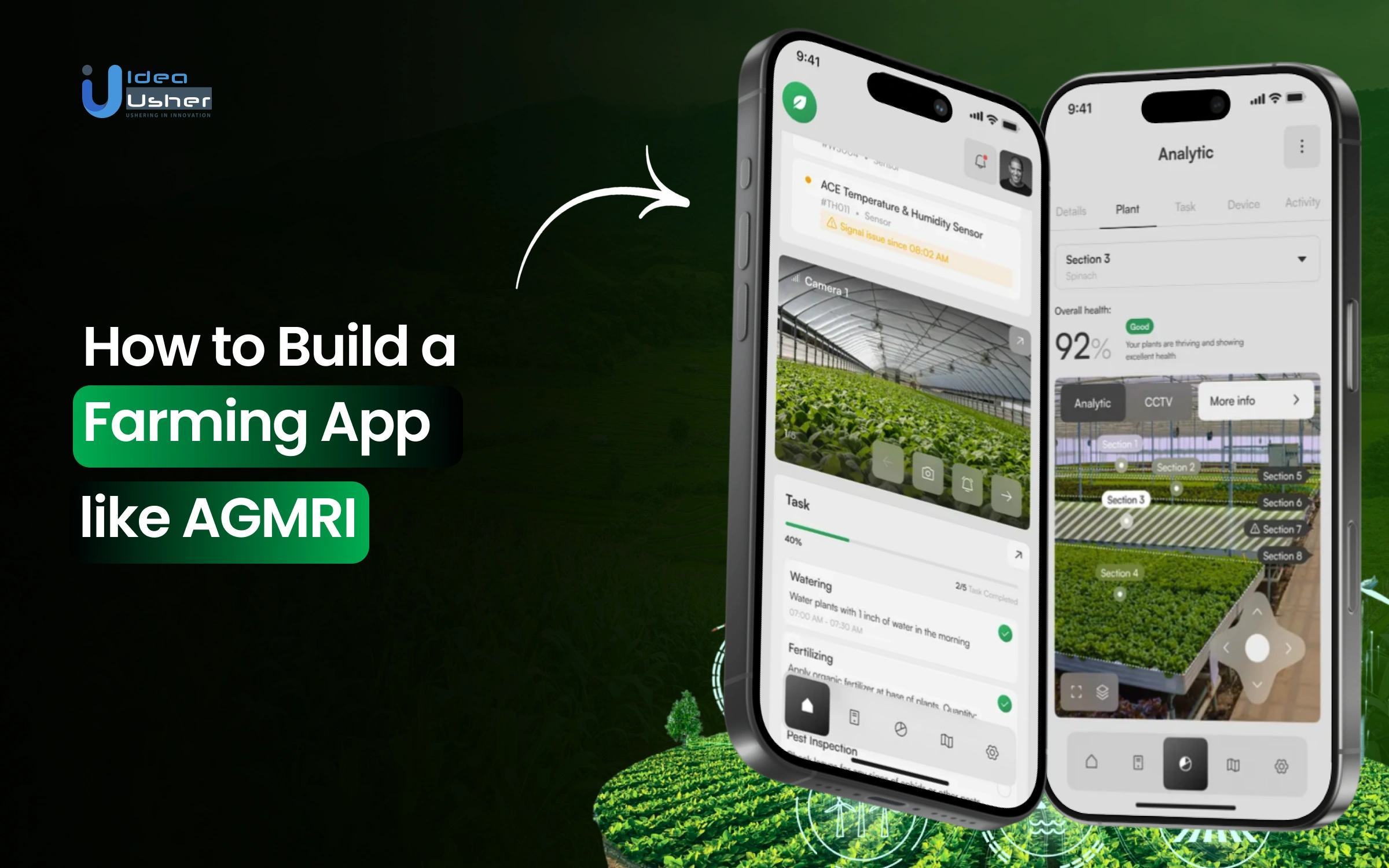
AGMRI is a crop-intelligence platform that uses ultra-high-resolution imagery, machine learning, and computer vision to deliver field-level, in-season monitoring for farmers, agronomists, and ag retailers. It identifies yield-limiting issues such as poor plant emergence, nutrient deficiencies, weed pressure, and disease stress well before they visibly impact crops. This farming app also includes features for virtual scouting, interactive map alerts, equipment diagnostics, and integrations with other farm management systems.
Business Model
AGMRI operates as a crop intelligence-as-a-service, delivering high-resolution aerial, satellite, and drone imagery integrated with weather, equipment, and scouting data. It provides continuous analytics and actionable alerts, working with growers, agronomists, and retailers to improve decision-making, reduce losses, and enhance efficiency.
Revenue Model
This model helps AGMRI bring in steady revenue and provide value for farmers and agribusinesses. Aligning growth with the productivity of growers boosts profitability and market acceptance.
- Subscription / SaaS Fees: Growers or agribusinesses pay recurring fees to access the AGMRI platform, alerts, dashboards, and field-level diagnostics. The subscription covers data processing, imagery access, and analytics services.
- Licensing / Data API Access: This farming app offers API access to its data and analytics for third parties like agritech partners, input suppliers, or large agricultural groups to embed insights into their systems.
- Enterprise / Custom Contracts: For large farms or agribusinesses, custom contracts likely include tailored features, higher frequency of data delivery, larger geographic cover, and consulting or deployment assistance.
- Growth via Acreage or Field Monitoring Scaling: Revenue grows as more acreage/fields are monitored. It can monitor millions of acres, so scaling acreage under management is a source of recurring revenue.
What Sets It Apart
AGMRI uses modern technology and real-time insights to help farmers make better decisions. It’s not just data; it’s actionable intelligence for the field.
- It processes large volumes of data (satellite + drone + equipment + weather) and turns it into actionable alerts rather than just static maps.
- It ties agronomic practices (planting date, hybrid choice, tillage, etc.) to observed yield outcomes, helping farmers test what works in their fields.
- It emphasizes early detection of issues before they become big losses. This is key because proactive management saves money and preserves yield.
How AGMRI Farming App Works?
AGMRI combines aerial imagery, AI analytics, and data integrations to help farmers monitor crops, detect issues, and make better field decisions. Its workflow can be understood in several connected stages:
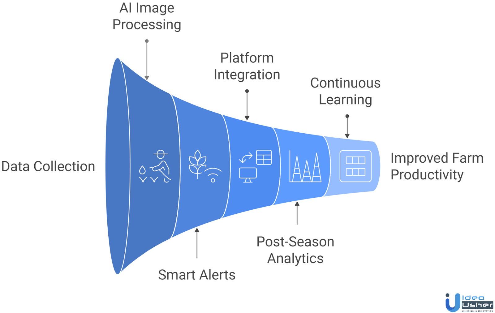
1. Data Collection from Multiple Sources
AGMRI gathers high-resolution aerial imagery, satellite data, and drone or ground-level inputs to provide comprehensive crop monitoring. This layered approach captures both overall field patterns and localized problems with precision.
2. AI-Powered Image Processing & Detection
The app uses AI models to analyze imagery, detecting crop emergence issues, nutrient deficiencies, weed pressure, and early disease signs. Millions of pixels are converted into actionable, zone-specific insights for targeted interventions.
3. Smart Alerts & In-Season Insights
Farmers receive real-time, zone-specific alerts for anomalies such as uneven emergence, nitrogen stress, or weed hotspots. These alerts guide immediate field action, saving time, reducing input waste, and improving crop outcomes.
4. Integration with Farm Platforms & Equipment
AGMRI syncs with platforms like John Deere Operations Center, enabling seamless import of field boundaries, yield data, and export of prescription maps. This ensures insights directly inform planting, spraying, and harvesting operations.
5. Post-Season Analytics (AGMRI Analyze)
The post-season module evaluates planting conditions, soil, weather, and crop management decisions. Farmers receive detailed reports highlighting yield-limiting factors and strategies for optimization in the following season.
6. Continuous Learning & Decision Support
With each season, this farming app builds richer datasets of individual fields. Machine learning models improve over time, offering more precise, actionable recommendations, enhancing decision-making and maximizing long-term farm productivity.
Why You Should Invest in Launching a Crop-Intelligence Farming App?
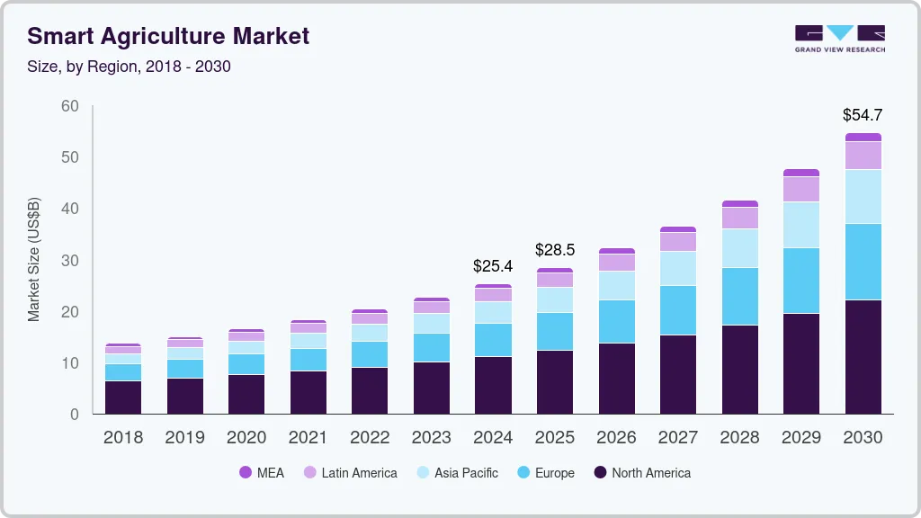
The global smart agriculture market was estimated at USD 25.36 billion in 2024 and is projected to reach USD 54.71 billion by 2030, growing at a CAGR of 13.9% from 2025 to 2030. This growth is fueled by the rising adoption of AI, IoT, drone/satellite imagery, and precision farming platforms that provide actionable intelligence to farmers.
AGMRI, developed by Intelinair, raised USD 3.5 million in seed funding in 2016, followed by a USD 20 million Series B round in 2021. This progression demonstrates strong investor confidence in crop-intelligence solutions that deliver real-time insights to farmers.
FarmWise, an agri-robotics and AI company, raised USD 14.5 million in Series A and an additional USD 45 million in Series B, bringing total funding to over USD 65 million. Its success shows growing interest in AI-driven farming solutions in the US market.
Taranis, an AI-powered crop-intelligence platform, secured USD 20 million in Series B (2018), USD 30 million in Series C (2020), and USD 40 million in Series D (2022), bringing its total funding to USD 100 million. Its ability to attract consistent investment highlights the scalability of precision farming technologies.
Indigo Ag, a US-based agtech leader, raised USD 300 million in a Series F round, further proving investor appetite for digital agriculture platforms that combine crop intelligence, sustainability, and carbon farming.
The smart agriculture market is undergoing a transformative shift. Investing in a crop-intelligence farming app positions you ahead in a rapidly expanding sector. With scalable technology, multiple revenue streams, and strong investor momentum, this space offers immense potential to drive profitability, sustainability, and long-term impact in global food systems.
How Crop-Intelligence Apps Drive Value for Farmers and Businesses?
Crop-intelligence apps go beyond traditional farm management by blending aerial imagery, AI analytics, IoT sensors, and predictive modeling into one ecosystem. They create measurable value for both growers and the broader agriculture industry in the following ways:
1. Precision in Resource Allocation
Crop-intelligence apps enable targeted application of seeds, water, and fertilizers, reducing waste and costs. Agribusinesses benefit from accurate demand forecasting and understanding usage patterns for better product planning.
2. Early Detection of Yield-Limiting Issues
AI-driven monitoring identifies crop stress, disease, or nutrient deficiencies early, allowing farmers to intervene promptly. Businesses gain insight to recommend precise solutions, increasing product adoption and farmer trust.
3. Data-Backed Decision Making
Farmers make informed decisions on planting, irrigation, and hybrid selection using quantified insights. Aggregated farm data helps businesses enhance R&D, product testing, and advisory services for precise client support.
4. Seamless Integration with Farm Equipment
By connecting with tractors, sprayers, and harvesters, apps streamline operations, reducing manual effort. Equipment manufacturers increase platform engagement while farmers benefit from real-time actionable insights directly on machinery.
5. Year-Round Value Creation
Post-season analytics allow farmers to review past performance and refine strategies, increasing long-term productivity. Businesses enjoy recurring engagement, subscription revenue, and upselling opportunities by delivering ongoing value.
6. Sustainability and Compliance Advantages
Apps track input usage, soil health, and crop outcomes, helping farmers comply with conservation programs. Businesses can demonstrate ESG performance, meet sustainability standards, and strengthen supply-chain credibility.
Key Features for a Farming App like AGMRI
A farming app like AGMRI should focus on delivering real-time insights and actionable recommendations to boost farm productivity. The features must empower farmers with data-driven decisions while ensuring ease of use and accessibility.
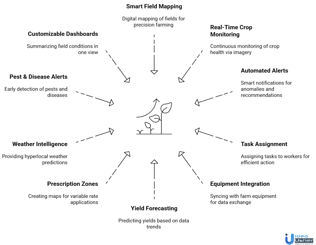
1. Smart Field Mapping & Zoning
A core feature should allow farmers to map their fields digitally and divide them into zones. These zones can then be linked to soil conditions, past yield data, and satellite/drone imagery. This creates the foundation for precision decisions like variable-rate seeding, fertilization, and spraying.
2. Real-Time Crop Health Monitoring
Use satellite and drone imagery to monitor crop conditions continuously. The app should highlight issues such as nutrient deficiencies, disease stress, or uneven emergence. Instead of generic “red/yellow/green” maps, it should provide layered insights about what’s happening, why it’s happening, and the potential impact if ignored.
3. Automated Alerts & Recommendations
Instead of just showing raw data, the app should trigger smart alerts when anomalies occur. For example, notifying farmers of weed pressure in a specific zone, or recommending irrigation adjustments after rainfall data changes. This turns the app into a proactive decision-making partner rather than a static dashboard.
4. Scouting & Task Assignment
The app should allow users to log field observations manually or assign tasks to scouts/workers directly from the platform. This feature ensures that when the app flags a problem area, action can be delegated and tracked in real time.
5. Integration with Farm Equipment & IoT Devices
The app should sync with GPS-enabled tractors, sprayers, drones, and IoT devices already in use. This ensures compatibility and real-time syncing of operational data like planting, spraying, and harvesting.
6. Yield Forecasting & Planning Tools
AI-driven forecasting should help predict yields based on weather, soil data, and crop health trends. Farmers can then use these forecasts to plan harvest logistics, storage, and market timing more effectively.
7. Prescription Zones for Variable Rate Applications
The app should allow farmers to generate prescription maps for variable rate input applications. For example, areas of a field that need more nitrogen receive it, while low-yield potential zones are given less, helping reduce waste and maximize ROI.
8. Weather & Climate Intelligence
Weather integration must go beyond simple forecasts. It should provide hyperlocal predictions, rainfall tracking, drought alerts, and even pest/disease risk models linked to weather conditions. This feature helps farmers prepare for potential problems.
9. Pest & Disease Alerts
A powerful feature is the early detection of pest infestations or crop diseases. By analyzing drone imagery, satellite data, and weather patterns, the app can flag high-risk areas and suggest targeted interventions like pesticide spraying or crop rotation. This proactive approach saves crops from large-scale damage and reduces unnecessary chemical use.
10. Customizable Dashboards & Field Cards
Farmers need information that’s quick to digest. Custom dashboards and “field cards” should summarize each field’s condition, alerts, and yield forecasts in one view, while still letting users dive deeper into detailed layers when needed.
11. Data Integration & Reporting
Allow seamless integration with other farm management systems. Provide downloadable reports for agronomists, lenders, or co-ops. Reports should not just be raw numbers. They should highlight actionable insights and the impact on ROI.
Development Process of a Farming App like AGMRI
The AGMRI farming app development combines precision agriculture tech with a user-friendly design to support better farming decisions. Our developers ensure every stage is aligned with real agricultural needs and backed by strong technical foundations.
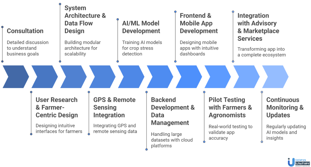
1. Consultation
We conduct a detailed consultation with you before launching an AGMRI farming app to understand your business goals, objectives, and target farmers. This ensures the app addresses real challenges and delivers meaningful, data-driven farming solutions.
2. User Research & Farmer-Centric Design
We focus on designing a simple, intuitive, and multilingual interface tailored for farmers. Our developers ensure offline-first access, clear dashboards, and easy navigation, making the AGMRI farming app development user-friendly even in rural areas with limited connectivity.
3. System Architecture & Data Flow Design
We build a modular architecture that integrates drone imagery pipelines, IoT sensor data, AI/ML models, and advisory systems. This structure allows the app to scale easily, adding features like financial tools or pest alerts without disrupting existing systems.
4. GPS & Remote Sensing Integration
Our developers integrate GPS-enabled machinery with remote sensing feeds from providers like Sentinel, Landsat, and DJI drones. We ensure seamless synchronization in your farming app, enabling accurate geospatial mapping essential for precision agriculture within the AGMRI farming app framework.
5. AI/ML Model Development
We train machine learning models for crop stress detection, pest identification, and yield prediction. Unlike generic models, ours use localized data such as soil, climate, and crop patterns, ensuring region-specific accuracy that farmers can trust for decision-making.
6. Backend Development
Our backend handles large datasets from satellites, IoT devices, and farm records. Using cloud platforms with auto-scaling, we ensure reliability during peak seasons. Data governance is strictly followed, protecting farmers’ privacy and maintaining compliance with agricultural data regulations.
7. Frontend Development
We design mobile apps with intuitive dashboards, field cards, and color-coded crop maps. Farmers receive push alerts for risks or opportunities, and offline-first functionality ensures usability even in areas with weak rural network connectivity.
8. Pilot Testing with Farmers & Agronomists
We conduct real-world farm testing with agronomists and selected farmers to validate app accuracy. Feedback is collected on usability, alert relevance, and insights, ensuring the farming app performs in actual agricultural conditions rather than simulated environments.
9. Integration with Advisory & Marketplace Services
Our team integrates advisory modules for fertilizer use, irrigation scheduling, and pest alerts, along with marketplace connections for buyers, input suppliers, and insurers. This transforms the AGMRI farming app into a complete ecosystem instead of a monitoring tool.
10. Continuous Monitoring & Updates
We monitor app performance post-launch, regularly updating AI models, weather-based insights, and crop recommendations. By acting on farmer feedback and retraining systems, we ensure the app evolves with changing agricultural practices and continues delivering long-term value.
Cost to Build a Farming App like AGMRI
Developing an AGMRI farming app requires investment across multiple phases, each contributing to a robust, scalable, and farmer-friendly solution. Below is a detailed cost breakdown to help businesses plan budgets effectively.
| Development Phase | Estimated Cost | Description |
| Consultation | $5,000 – $10,000 | Understand business goals, target users, and app objectives to define core features and priorities. |
| System Architecture | $8,000 – $15,000 | Design modular architecture integrating satellite/drone imagery, sensor data, AI models, and advisory modules for scalable data handling. |
| AI/ML Model Development | $12,000 – $22,000 | Develop AI models for crop stress detection, yield prediction, and pest/disease risk assessment using historical and real-time datasets. |
| Backend Development | $10,000 – $18,000 | Build secure, cloud-based backend to manage large datasets, auto-scaling during peak seasons, and ensure data governance. |
| Frontend Development | $10,000 – $20,000 | Develop mobile apps with intuitive dashboards, map-based interfaces, and field cards for user-friendly navigation and data visualization. |
| GPS & Remote Sensing Integration | $5,000 – $10,000 | Integrate GPS-enabled equipment, satellite, and drone feeds for accurate field mapping and remote sensing. |
| Integration with Advisory & Marketplace Services | $8,000 – $12,000 | Connect the app to input suppliers, crop buyers, irrigation recommendations, and insurance services for a complete farming ecosystem. |
| Testing | $5,000 – $10,000 | Validate app functionality, GPS accuracy, AI predictions, and overall usability in simulated and real-world conditions. |
| Continuous Monitoring | $7,000 – $15,000 | Maintain and update AI models, features, and scalability to keep the app aligned with evolving farming practices. |
Total Estimated Cost: $60,000 – $125,000
Note: This is an estimated cost and the actual cost depends upon feature complexity, tech stack selection, third-party integration, etc. Consult with IdeaUsher for a tailored AGMRI farming app solution that fits your farm’s specific needs. Our experts guide you through development, integration, and deployment to ensure maximum efficiency and ROI.
Tech Stack Recommendation for AGMRI-like Farming App Development
Building an app like AGMRI requires a carefully chosen tech stack that can handle large geospatial datasets, AI-driven insights, GPS integration, and farmer-friendly interfaces. Here’s a layer-by-layer breakdown:
1. Frontend
The frontend must be intuitive, multilingual, and offline-ready since many farmers operate in low-connectivity areas.
- Flutter: Ideal for building cross-platform apps (Android + iOS) with smooth UI and offline sync support.
- React Native: Another option for scalability and modular UI, useful if rapid feature iterations are expected.
- PWA (Progressive Web App) Layer: For farmers who prefer lightweight browser-based access without downloading apps.
2. Backend (Data Orchestration & Scalability)
The backend must handle satellite imagery, drone data, IoT streams, and AI results, while remaining secure and scalable.
- Node.js: Great for handling concurrent data requests like real-time GPS tracking and alerts.
- Django (Python): Ideal for building AI/ML-driven APIs and managing large data pipelines reliably.
- GraphQL API Layer: Recommended for efficient querying, especially when farmers want field-specific insights quickly.
3. Database (Geospatial & Time-Series Data)
AGMRI-like apps deal with spatial maps, satellite images, and continuous sensor feeds, so databases must handle more than just rows and columns.
- PostgreSQL + PostGIS: Best for geospatial data storage and queries (field boundaries, prescription maps).
- MongoDB: Useful for unstructured data like drone imagery metadata and scouting logs.
- Time-Series DB (InfluxDB or TimescaleDB): For continuous IoT sensor data (soil moisture, weather patterns).
4. Remote Sensing & Drone Integration
The system must integrate satellite APIs and drone SDKs to collect field imagery.
- Sentinel & Landsat APIs: Free and reliable satellite imagery sources for NDVI and vegetation indices.
- DJI Mobile SDK: For controlling drones and fetching aerial imagery directly into the app.
- Pix4D API: For advanced image stitching, 3D field models, and crop health analysis.
5. AI & Machine Learning (Crop Insights Engine)
AI is the heart of an AGMRI-like app. It powers pest/disease detection, yield forecasting, and stress analysis.
- TensorFlow / PyTorch: For building and deploying deep learning models to classify crop stress and predict yields.
- Google Earth Engine (GEE): Useful for processing satellite imagery at scale with built-in geospatial datasets.
- ONNX Runtime: For running AI models efficiently on mobile devices in offline scenarios.
6. IoT & Cloud Connectivity
IoT integration ensures real-time syncing of soil, weather, and equipment data.
- AWS IoT Core: Handles IoT device connections, real-time data ingestion, and event-driven triggers.
- Azure IoT Hub: Strong choice if building enterprise-scale farm integrations with multiple device types.
- GCP IoT Core: For teams already leveraging Google’s AI/ML stack and geospatial capabilities.
7. Data Visualization & Analytics
Farmers and agronomists need visual clarity more than raw data.
- Mapbox / Leaflet.js: For rendering field maps, GPS paths, and crop health overlays.
- Kepler.gl: For advanced geospatial visualization and layered analytics.
- Power BI / Tableau Integration: Optional for agribusinesses that want dashboards beyond the farmer app.
8. Security & Data Governance
Farmer data is highly sensitive and often subject to regional agri-data policies.
- OAuth 2.0 + JWT: For secure authentication.
- End-to-End Encryption: Protects IoT and satellite data during transmission.
- Role-Based Access Control (RBAC): Ensures agronomists, farmers, and policymakers have appropriate access levels.
Challenges & How to Overcome Them?
Building a farming app like AGMRI farming app comes with unique challenges, from data accuracy to scalability. Addressing these hurdles effectively ensures a reliable, efficient, and widely adoptable precision agriculture solution.
1. Data Accuracy and Reliability
Challenge: Agricultural decisions depend on precise satellite imagery, GPS signals, and sensor data. Inaccurate inputs can lead to wrong crop recommendations, lowering farmer trust in the app.
Solution: We integrate multiple data sources including satellite, IoT sensors, and weather APIs. Our AI-driven validation cross-checks and corrects inconsistencies, ensuring that the AGMRI farming app development delivers highly accurate and dependable insights.
2. Connectivity in Rural Areas
Challenge: Farmers in remote locations often experience low internet connectivity, limiting real-time access to app insights and data-driven recommendations.
Solution: We implement offline-first functionality where the AGMRI-like farming app caches data locally and synchronizes automatically when connectivity is restored. We also design lightweight features to maintain usability in low-bandwidth areas.
3. User Adoption and Digital Literacy
Challenge: Low digital literacy among farmers can hinder adoption of sophisticated apps, making technology underutilized.
Solution: We design a simple, intuitive interface with multilingual support, voice-assisted navigation, and guided tutorials. These features make the AGMRI-like farming app easy to use, encouraging adoption even among non-tech-savvy farmers.
4. Pest and Disease Prediction Accuracy
Challenge: Misidentifying pests or diseases could cause crop losses and reduce farmer confidence.
Solution: We continuously train AI/ML models with region-specific datasets and incorporate feedback loops from farmers. Collaborating with agricultural research institutes helps us enhance the predictive accuracy of the farming app.
Conclusion
Building a farming app like AGMRI requires a thoughtful balance of technology, user needs, and scalability. With features such as satellite imaging, AI-powered crop analysis, and real-time field monitoring, the app sets a strong benchmark for modern agriculture. Successful AGMRI farming app development depends on integrating these advanced tools while ensuring accessibility for farmers across different regions. By focusing on usability and long-term value, such apps can transform agricultural practices, helping farmers improve productivity, reduce risks, and build sustainable strategies for the future of farming.
Why Choose IdeaUsher for Farming App Development?
At IdeaUsher, we bring expertise in precision agriculture technologies, delivering apps that leverage satellite imagery, IoT data, and AI-powered insights. Whether you want to replicate or innovate beyond AGMRI, our team builds scalable farming apps tailored to your vision.
Why Work with Us?
- Advanced Tech Stack: We integrate AI, IoT, GPS, and cloud solutions for accurate insights.
- Tailored Solutions: Every farming app is customized to meet your specific requirements.
- Proven Experience: Our agritech portfolio showcases success in delivering high-performance applications.
- Future-Ready Platforms: We ensure your app remains adaptable as agricultural technologies evolve.
Explore our portfolio to see how we’ve supported businesses in building transformative agritech solutions.
Let us help you create a powerful AGMRI-style farming app that empowers both farmers and enterprises.


FAQs
An app like AGMRI should offer satellite-based field mapping, crop health analysis, irrigation management, and AI-driven recommendations. These features help farmers make better decisions, reduce operational costs, and improve crop yield efficiently.
AGMRI farming app development provides farmers with real-time insights, predictive analytics, and resource optimization. This enhances decision-making, reduces waste, and increases productivity, making farm management more precise and data-driven.
Technologies such as AI, IoT sensors, GPS mapping, and cloud computing are essential. They enable accurate monitoring, efficient data processing, and scalable solutions that meet diverse agricultural needs.
By offering precise irrigation control, soil monitoring, and resource optimization, the app reduces environmental impact. Farmers can maintain soil health, conserve water, and apply inputs efficiently, supporting sustainable and long-term farming practices.