


Key Takeaways
- Map-based travel planner apps help users plan trips visually through interactive maps, route optimization and location intelligence.
- Modern platforms combine POI discovery, itinerary planning and navigation into one connected travel experience.
- Core features include offline maps, multi-stop route planning and collaborative trip management.
- Revenue comes from travel bookings, premium subscriptions, API licensing and white-label solutions.
- How IdeaUsher can help you build map-based travel apps with geospatial infrastructure, AI itinerary engines and scalable cloud architecture.
Travel planning is increasingly becoming a spatial decision-making process rather than a simple search activity. Travelers no longer want disconnected lists of attractions, restaurants and landmarks. They want a map-based travel planner that helps them understand how destinations connect geographically, optimize routes and build realistic itineraries around location context.
Traditional travel apps focused on recommendations, reviews and booking workflows while leaving users to manually organize destinations into workable travel plans. Modern travelers increasingly expect interactive maps, route optimization, location intelligence, attraction discovery and itinerary planning integrated into a single visual experience. The shift is not about providing more travel information. It is about helping users make better decisions through spatial awareness and real-world feasibility.
In this blog, we will talk about core features, architecture, development costs, travel APIs and how IdeaUsher can help build a map-based travel planner like Sygic Travel by combining maps, attractions and itinerary planning into one connected ecosystem.
Why Map-First Planning is Replacing Traditional Itineraries
The days of planning trips with spreadsheets and static documents are fading. Travelers now prefer map-first planning, an interactive approach that organizes journeys around locations and routes rather than rigid timelines.
The global travel navigation app sector is valued at $5.3 billion in 2024 and is moving steadily at a 12.1% CAGR to reach $14.8 billion in 2033. At the heart of this growth is an urgent consumer demand for mobile itinerary management tools.

Because an app like Sygic Travel functions as a map-first platform, it taps into the booming Location-Based Services (LBS) market, valued at $44.63 billion and projected to hit $163.77 billion at an explosive compounding annual growth rate (CAGR) of 20.30%.
According to the reports, 53% of travelers are comfortable letting AI suggest travel options, highlighting increasing trust in AI-powered itinerary recommendations and 40% of travelers use or are willing to use AI to build travel itineraries, demonstrating growing acceptance of AI-generated trip plans.
A. The Shift Toward Visual Travel Discovery
Human brains process visual information significantly faster than text, and modern travel behavior heavily reflects this biological preference. Visual travel discovery allows users to browse destinations, accommodations, and activities simultaneously within a clear spatial context, completely shifting the planning funnel.
- Ditching the App Overload: Expedia Group reports that nearly 70% of travelers want a single, unified application for booking and planning. Traditional methods splinter this process, forcing users to switch between blogs, booking sites, and navigation tools.
- Surging App Adoption: The frustration with fractured, non-visual planning has led users to adopt specialized tools. Global data shows downloads for the top 10 travel planning apps grew by 28% year-over-year, as consumers demand integrated, visual technology.
- Immersive Explorations: Modern travelers now expect interactive media over static images before booking. Consequently, the industry has seen a 22% increase in adopting immersive tools like 360-degree tours and AR integrated into travel platforms.
B. How Interactive Maps Improve Trip Planning
Traditional chronological lists look good on paper but frequently fail on the ground because they ignore the physical distances between activities. Interactive maps optimize the logistics of travel, saving both time and money.

This advantage becomes particularly apparent when travelers begin evaluating how destinations, travel times, and costs interact within a real-world geographic context.
- Eliminating Geographic Bottlenecks: Text-based planning often leads to logistical errors, like scheduling distant activities back-to-back. Mapping platforms resolve this by visually anchoring points of interest, allowing travelers to group activities by neighborhood to reduce transit time and fatigue.
- Contextualizing Financial Decisions: Map-first platforms integrate data beyond geography. For example, Google Trip uses predictive AI in maps to show real-time neighborhood pricing trends. This helps travelers balance location convenience with shifting costs.
- Enhanced Destination Discovery: Interactive maps go beyond standard itineraries by surfacing nearby attractions, events, and hidden gems. Visualizing these in context creates more personalized journeys absent from traditional lists.

What Makes Sygic Travel Different From Travel Apps
Sygic Travel (now rebranded as Tripomatic) is a map-based travel planning platform that helps travelers discover destinations, create day-by-day itineraries, explore attractions on interactive maps, and organize trips using travel guides, route planning, and offline map capabilities in a single application. The platform was officially rebranded from Sygic Travel to Tripomatic in 2024 while retaining its core travel planning functionality.
While generic itinerary apps function primarily as digital checklists or glorified note-taking templates, Sygic Travel is architected from the ground up as an integrated spatial mapping database. It bridges the gap between dreaming about a destination and navigating its physical layout, eliminating the friction of cross-referencing multiple separate apps during a trip.
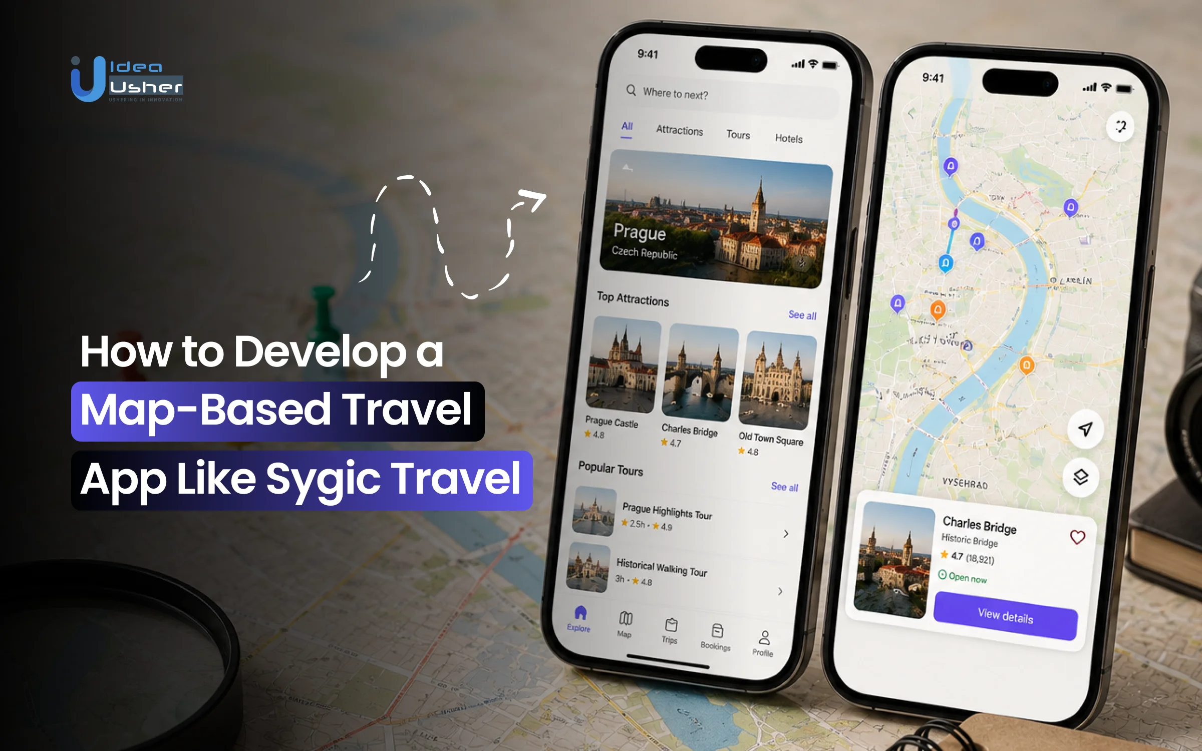
A. Map-Centric User Experience
Most travel apps relegate maps to a secondary, passive window used only after an itinerary text list has been built. Sygic Travel reverses this paradigm by placing an interactive, detailed canvas at the center of the entire planning interface.
- Split-Screen Continuity: The desktop and mobile layouts split screen space between a calendar timeline and a live map view. Dragging an item onto your daily schedule instantly updates a visual path on the map, allowing you to catch geographic mistakes in real time.
- Contextual Visual Hierarchy: Instead of uniform generic pins, Sygic uses distinct, color-coded markers and custom 3D landmark icons (such as historical churches or museums) to let planners instantly read a city’s layout without needing to click on every single spot.
B. Destination Discovery Through POI Intelligence
Sygic does not rely on simple, unverified web-scraped lists. It houses an incredibly robust, proprietary database focused heavily on actionable geographic metadata.
- Massive Global Reach: The platform features more than 50 million Points of Interest (POIs) across the globe, explicitly curated for travelers rather than standard commercial businesses.
- Rich Media Profiles: Selecting a point of interest surfaces exhaustive context without leaving the mapping environment. This includes:
- Detailed opening hours and ticket pricing.
- Accurate duration estimates (e.g., “average visitor spends 2.5 hours here”).
- Immersive 360-degree videos and photos for over 500 popular global destinations, giving planners an authentic sense of place beforehand.
C. Route Optimization for Multi-Stop Trips
The hallmark feature that sets Sygic apart from basic booking applications is its robust, algorithmic vehicle and pedestrian routing engine.
The Travelling Salesperson Problem: Manually organizing a 6-stop itinerary day to find the shortest possible path is mathematically exhausting. Sygic solves this instantly with algorithmic computation.
- Pin Selected Sights (Step 1): Select all the museums, restaurants, and sights you want to visit in a single day and throw them onto your schedule in any random order.
- Lock Fixed Constraints (Step 2): Set fixed times for mandatory events, such as a pre-booked guided tour reservation at 2:00 PM or a strict dinner reservation time.
- Execute Optimization (Step 3): Click the “Optimize” button. Sygic’s engine recalculates the entire sequence based on walking distances, driving times, and business operating hours.
- Deploy Streamlined Itinerary (Step 4): Receive a perfectly streamlined, sequential daily route that cuts down backtracking and significantly reduces transportation costs.
D. Offline Travel Planning and Navigation
International travel frequently means dealing with dead cell zones, expensive roaming charges, and unreliable local Wi-Fi connections. Sygic remedies this by offering true offline utility that preserves planning capability.
- Vector Map Technology: Instead of saving clunky, pixelated map images, Sygic downloads crisp, high-performance vector maps powered by OpenStreetMap. These take up very little device storage while remaining infinitely zoomable.
- Fully Functional Offline Search: Even without cellular data or an active internet connection, users can search the downloaded POI database, calculate foot or car navigation routes, and view full scheduling details seamlessly.
E. Collaborative Itinerary Building
Planning group travel using basic text apps typically degenerates into chaotic group chats and messy version-control issues on shared spreadsheets. Sygic treats travel planning as a collaborative workspace.
| Collaborative Feature | How It Solves Group Friction |
| Real-Time Syncing | Every member with access sees itinerary additions or schedule changes across devices instantly, preventing double-bookings. |
| Multi-User Permission Tiers | Organizers can assign distinct “Viewer” or “Editor” permissions to keep core logistics secure while allowing input. |
| Shared Cost Estimates | The platform tracks total distances and route sequences, allowing groups to project realistic shared transit expenses together. |
The Location Intelligence Engine Behind the Map-Based Travel App
While a traveler simply sees an intuitive, moving map on their screen, a sophisticated location intelligence engine is constantly running in the background. This engine serves as the silent brain of the application, working fluidly across the four distinct phases of a live trip to turn complex geographical data into a seamless, stress-free travel experience.

1. Points of Interest Aggregation
The engine continuously gathers, cleans, and updates millions of travel listings from global databases, transforming fragmented web data into a single, cohesive map experience.
- Smart Duplicate Elimination: When multiple data streams return the same monument with slightly different names or coordinates, the engine automatically merges them into a single, clean pin.
- Unified Information Profiles: Scattered details like shifting seasonal hours, ticket prices, and traveler photos are neatly organized into standardized, easy-to-read digital attraction cards.
2. Geospatial Search Infrastructure
To deliver instant search results as a user types or moves around, the app relies on a highly responsive location-sorting framework rather than standard text searching.
- Geographic Box Sorting: The infrastructure groups locations into virtual, localized boxes, allowing the server to scan millions of spots globally and return answers in a fraction of a second.
- Proximity-Based Filtering: The app instantly processes radius requests, ensuring that when a traveler searches for “cafes,” they only see options immediately relevant to their physical location.
3. Map Rendering and Visualization
Instead of using slow, data-heavy map images that drain mobile plans, the platform utilizes advanced digital drawing tech to keep the map fast, crisp, and interactive.
- Lightweight Data Streaming: Map data is sent to the phone in tiny, compressed data packages, cutting mobile data usage down by up to 80% compared to traditional image-based maps.
- On-Device Visual Controls: Because the user’s phone handles the map styling, zooming, rotating, and switching to night mode happens instantly with zero screen lag.
- Fluid 3D Urban Landscapes: The engine reads building layout data to draw beautiful, interactive 3D structures on the screen, helping travelers orient themselves visually in real time.
4. Route Optimization Algorithms
Organizing a multi-stop vacation day in the shortest possible path is a major mathematical challenge that the engine solves automatically in the background.
- High-Speed Route Shortcuts: The system pre-calculates global road networks to create digital transit shortcuts, allowing it to evaluate complex cross-city routes instantly.
- Smart Timeline Arrangement: The engine analyzes walking trails, train timetables, and attraction closing times simultaneously, automatically re-ordering a disorganized 6-stop day into a perfectly streamlined path.
5. Real-Time Travel Data Processing
A resilient travel map cannot remain static; it must constantly adapt to live environmental variables and infrastructure updates to keep the traveler moving safely.
- Live Transit Integration: The platform maintains constant, low-latency connections to local public transit hubs, capturing live train delays, cancellations, and platform changes instantly.
- Instant Local Recalculations: If a traveler misses a turn or deviates from their schedule, an on-device tracking engine redraws their walking paths instantly without needing a cellular signal.
Core Features of a Travel App Like Sygic Travel
Building a modern map-first travel platform requires a highly technical ecosystem that bridges visual cartography, localized algorithmic routing, and contextual data layers. To outperform traditional, linear scheduling software, an elite travel application must integrate an array of specialized core capabilities.

1. Interactive Destination Discovery Maps
The foundation of a map-first platform is an interactive digital canvas that serves as the primary gateway for all discovery and spatial organization. Rather than treating maps as a static after-thought, this module embeds intelligence directly into the geographical interface.
- Dynamic Visual Layers: Maps leverage customizable toggle overlays, allowing users to instantly filter the world map by historical significance, transit density, or neighborhood safety metrics.
- Contextual Pin Densities: As users zoom into a destination, the map dynamically clusters or reveals localized attractions. This visual discovery layout ensures travelers instantly see which parts of a city are dense with activities versus areas that require extensive transit.
2. AI Travel Itinerary Generator
To eliminate the manual research phase that traditionally takes hours, an advanced travel app embeds an Artificial Intelligence reasoning engine linked directly to verified local map data.
- Multivariable Synthesis: The AI ingests unstructured user intent such as budget tiers, unique dietary constraints, travel paces (e.g., “relaxed” vs. “fast-paced”), and the presence of children and cross-references it with localized factors like weather patterns, seasonal events, and operating hours.
- Proactive Conflict Avoidance: Unlike generic text-based LLMs that hallucinate schedules, map-integrated AI cross-checks logic instantly. If a user selects a museum that is closed on Mondays, the AI dynamically restructures the recommendation matrix without user intervention.
3. Smart Day-by-Day Trip Planning
Transitioning from a chaotic pile of saved places to a functional journey requires a structured temporal environment mapped alongside the geographic layout.

The itinerary planner tightly integrates time-based scheduling with map visualization, helping travelers understand not just where they are going, but also how each activity fits into the overall trip timeline.
- The Timeline Split-View: Users organize their trip using an interactive calendar sidebar anchored directly to the primary map display. Dropping an event into a specific morning time slot automatically adjusts the map to highlight that day’s geographical boundaries.
- Visual Trip Structuring: The application handles multi-day complexity by color-coding daily tracks. This macro-level view lets travelers quickly inspect if their 5-day trip is balanced or if Day 3 is over-scheduled.
4. Multi-Destination Route Planning
When a trip expands past a single city center into a cross-country road trip or multi-nation tour, the application scales its routing logic to manage macro-geography.
- Inter-City Sequences: The software coordinates macro-hubs (e.g., arriving in London, train to Paris, flight to Rome) while simultaneously preserving the internal day-to-day micro-itineraries built inside each individual destination.
- Geographic Nesting: Multi-destination planning allows users to seamlessly zoom out to manage cross-border visas and travel legs, then zoom in to adjust a single coffee shop pin within an isolated neighborhood.
5. Multi-Modal Travel Route Optimization
Travelers rarely rely on just one mode of transportation. True optimization requires real-time computational data from diverse transportation networks.
| Transit Mode | Core Optimization Metrics |
| Pedestrian & Cycling | Evaluates sidewalk infrastructure, dedicated bike lanes, elevation changes, and foot-traffic density. |
| Driving & Ridesharing | Ingests real-time traffic delays, parking zone availability, and local toll structures. |
| Public Transportation | Syncs directly with local GTFS (General Transit Feed Specification) data for live train, tram, and bus schedules. |
| Aviation Links | Connects to global flight distribution systems to factor in terminal transfer times and check-in overhead. |
6. Offline Maps and Navigation
High-end travel applications must operate perfectly in extreme conditions, such as high-density stone buildings, remote natural parks, or international borders without cellular roaming.
- Pre-Downloaded Vector Packages: Instead of raw raster images, the platform downloads lightweight vector map packages. These packages bundle localized road meshes, pedestrian walking paths, elevation curves, and complete address registries directly into local storage.
- Hardware-Only GPS Tracking: By utilizing a smartphone’s internal GPS chip against locally cached spatial routing graphs, the app provides voice-guided turn-by-turn navigation, route recalculations, and full schedule access with zero network packets sent or received.
7. Travel Time and Distance Estimation
The final layer of a resilient itinerary is a continuous validation system that ensures a planned day is physically achievable.
Feasibility Engine: Yolks scramble on heat, and travel plans scramble on bad timing. If a user schedules two activities 20 miles apart with only a 15-minute gap between them, the system flags a visual conflict alert.
- Traffic-Aware Calculations: Distance logic calculates spatial buffers using real-world historical traffic parameters based on the precise day of the week and hour of the day.
- Pedestrian vs. Vehicular Drift: The app recognizes the difference between a straight line on a map and physical layout realities, factoring in pedestrian-only walking zones, subway station stairs, and complex highway exit loops to provide highly accurate ETA calculations.
8. Points of Interest and Travel Guides
An itinerary tool is only as good as the underlying data populating its pins. The platform acts as a hyper-detailed, localized database curated explicitly for exploration.
- Deep Metadata Profiles: Each of the millions of Points of Interest (POIs) contains dense informational records: opening hours, optimal arrival windows to dodge tour buses, typical visit durations, and localized pricing tiers.
- Unified Reviews & Insights: Instead of splitting data across disjointed web forums, the app unifies crowd-sourced traveler feedback, professional destination write-ups, and official landmark warnings into a single interactive card window.
9. Collaborative Trip Planning and Sharing
Group coordination is notoriously fragile. To prevent communication breakdowns, the app acts as a single source of truth with real-time multi-user syncing.
- Shared Workspace Architecture: Much like editing a collaborative cloud document, multiple users can open the same map itinerary simultaneously. Moving a pin, editing a departure time, or dropping a hotel choice displays instantly across all connected mobile and web screens.
- Permission Control & Invitation Engine: Organizers can share secure links with travel groups, granting full editing rights to core planners while keeping casual companions on “Read-Only” visibility to avoid accidental schedule deletions.
10. Drag-and-Drop Itinerary Builder
The user interface must minimize friction, turning the complex mathematics of geographic coordination into an intuitive, tactile experience.
- Select Itinerary Pin (Action 1):Tap or click on any attraction or restaurant pin from your saved discovery bucket on the map.
- Drop Into Timeline (Action 2): Drag the item directly into your chronological daily timeline sidebar to lock down its rough placement.
- Rearrange Chronology (Action 3): Slide items up or down to adjust your day’s pacing. The background map redraws its transit lines instantly to reflect the new path.
- Finalize Custom Order (Action 4): Lock the changes, allowing the database to recalculate step-by-step walking vectors and update arrival times.
How to Develop a Map-Based Travel Planner App Like Sygic Travel
Engineering a map-first travel platform requires a highly coordinated, phased lifecycle. Because the application handles massive geospatial data streams, real-time collaboration, and complex routing algorithms simultaneously, the development pipeline must prioritize absolute mathematical accuracy alongside an intuitive user experience.

1. Define the Travel Planning Use Cases
In this foundational phase, our team analyzes your target audience to outline core user journeys, map out destination scopes, and establish the precise problems your platform will solve for global travelers.
- Target Traveler Profiles: Understand the specific needs of different traveler types, from budget-conscious solo backpackers who prefer flexibility to luxury family travelers who need seamless bookings and well-planned schedules.
- Trip Typology Mapping: Engineering custom application workflows optimized specifically for weekend city breaks, extended road trips, or multi-country expeditions.
- Geographic Coverage Parameters: Defining localized regional boundaries or global scales determines data caching architectures and international mapping API requirements.
- Core Journey Blueprinting: Mapping user actions from initial destination discovery to real-time navigation establishes the foundation for software development.
2. Design a Map-First User Experience
Our design team prioritizes spatial awareness by creating interactive interfaces where a dynamic, highly responsive map serves as the central hub for all discovery, scheduling, and user engagement.
- Split-Screen Interface Engineering: Creating balanced, simultaneous views of the map canvas and itinerary timeline maximizes user productivity across devices.
- Visual Hierarchy Layouts: Designing intuitive, color-coded POI pins and custom landmark markers enables immediate spatial comprehension without cognitive clutter.
- Tactile Drag-and-Drop Flows: Developing seamless gesture mechanics allowing users to move attractions directly from discovery panels into calendar slots.
- Contextual Alert Overlays: Designing clear, unobtrusive notification designs that instantly flag impossible transit times or scheduling overlaps visually.
3. Build the Geospatial Data Infrastructure
Our engineers construct a rock-solid database foundation to handle massive spatial coordinate sets, lightning-fast rendering speeds, location intelligence layers, and intricate routing matrix calculations.
- High-Performance Spatial Databases: Implementing robust PostgreSQL engines with PostGIS extensions ensures rapid indexing and querying of worldwide geographical coordinates.
- Proprietary POI Repositories: Architecting structured data tables to store dense metadata, including exact coordinates, entry costs, and visitor durations.
- Vector Tile Serving Systems: Building infrastructure to stream lightweight map layers efficiently, minimizing bandwidth consumption while maintaining crisp visual zoom.
- Custom Matrix Routing Models: Developing foundational server-side graph engines capable of processing thousands of multi-stop distance computations in milliseconds.
4. Integrate Travel and Mapping APIs
No travel platform operates as an isolated island and to populate the spatial database and fuel basic utilities, our developers must orchestrate a network of external data providers.
| Service Category | Industry Standard Providers | Primary Implementation Purpose |
| Map Tiles & Geocoding | Mapbox / Google Maps API | Delivers the base visual cartography, satellite overlays, and address-to-coordinate translation. |
| Public & Private Transit | OpenStreetMap / GTFS Feeds | Powers live train, tram, bus, and flight connection tracking across international networks. |
| Booking & Inventories | Amadeus / Booking.com API | Pulls real-time room availability, pricing tiers, and activity ticket processing slots. |
| Environmental Context | OpenWeatherMap API | Ingests live weather forecasts to trigger activity warnings (e.g., flagging indoor museum backups on rainy days). |
5. Develop the AI Itinerary Engine
Our developers build an intelligent artificial intelligence optimization engine that instantly generates personalized, realistic, and logistically sound travel itineraries transforming raw user preferences and scattered map layers.
Algorithmic Solvers: The AI engine resolves the Traveling Salesperson Problem (TSP) using advanced heuristics like Ant Colony Optimization or Genetic Algorithms to determine the shortest route via physical roads.
- Machine Learning Recommendation Matrices: Building algorithms that learn from user behaviors to deliver increasingly accurate attraction, restaurant, and hotel suggestions.
- Heuristic Route Optimization Solvers: Implementing advanced algorithms to eliminate backtracking by automatically re-ordering multi-stop daily plans into logical paths.
- Temporal Feasibility Gatekeepers: Developing code that automatically audits itineraries against operational hours, local time zones, and average stay durations.
- Budget-Conscious Allocation Logic: Engineering smart filters that dynamically tailor generated trip scopes to fit strict spending tiers effortlessly.
6. Implement Offline Travel Functionality
The mobile application must be capable of running its core spatial logic completely severed from the internet because international roaming can be unreliable.
- Vector Base Map Packaging (Phase 1): The server slices large spatial environments into highly compressed, lightweight vector tiles (typically utilizing Protocol Buffers) sorted by city or region.
- User Download Initiation (Phase 2): The user triggers a region download over Wi-Fi. The client app pulls the vector tiles, localized POI registries, and routing graph meshes directly into local device storage.
- Network Loss Event (Phase 3): Upon losing data connectivity on-trip, the app’s interceptor layer switches all mapping and address requests from remote API endpoints to the local storage engine.
- Offline Spatial Execution (Phase 4): The app uses the device’s built-in GPS hardware to calculate real-time orientation, render the offline map canvas, and compute pedestrian routes with zero network dependency.
7. Build Collaborative Planning Features
Group coordination requires a robust multi-user synchronization layer built on real-time networking web protocols to ensure everyone stays on the same page.
Concurrency Conflicts: If Traveler A drags a lunch pin to 12:00 PM while Traveler B deletes that same restaurant on a separate device at the exact same moment, the system must handle the state collision cleanly.
- Web-Socket Synchronization Frameworks: Deploying low-latency, real-time data streaming engines so adjustments reflect across all group devices within milliseconds.
- Granular User Permission Tiers: Coding secure access levels that distinguish primary trip managers from read-only companions to avoid accidental deletions.
- Centralized Activity Notification Logs: Building chronological feeds that track member additions, comment updates, and schedule shifts inside shared trip profiles.
- Shared Expense Estimation Frameworks: Integrating group cost calculation systems that distribute estimated transit and activity fees evenly among travel parties.
8. Test, Launch, and Optimize the Platform
The final engineering phase transitions the application from a staging sandbox into a scalable, production-ready international platform.
- Rigorous Accuracy Validation: QA engineers utilize automated integration tests to simulate diverse global itineraries, ensuring the routing engine handles complex interchanges and multi-timezone transitions without failure.
- Performance & Load Profiling: Stress-test WebSocket layers and API routers to ensure stability under high concurrent traffic during peak seasonal travel.
- Post-Launch Telemetry & Expansion: After iOS and Google Play deployment, developers use analytics to monitor user metrics. Data pipelines track route deviations to refine algorithm weights, while teams expand global POI and vector map coverage.
Cost to Develop a Map-Based Travel Planner App
The phases map directly to the development process outlined above, prioritizing core geospatial and routing features to minimize initial capital expenditure while delivering maximum user value. The table below provides a targeted cost breakdown structured around an Minimum Viable Product (MVP) scope.
A. Sygic like Travel Planning App MVP Cost Breakdown
Developing a map-based travel planner app involves multiple stages, from product planning and UI/UX design to backend development and testing. The table below outlines the estimated MVP costs across each development phase.
| Development Phase | What the Phase Covers | Estimated Cost |
| Use Case Definition | Auditing target traveler profiles, mapping core journeys, and establishing foundational project scopes. | $5,000 – $10,000 |
| Map-First UX/UI Design | Crafting split-screen wireframes, interactive map interfaces, and tactile drag-and-drop workflow prototypes. | $8,000 – $15,000 |
| Geospatial Infrastructure | Setting up PostGIS databases, vector tile servers, and primary multi-stop routing engines. | $15,000 – $30,000 |
| API Integration | Connecting mapping SDKs, core location services, and essential hospitality booking engine gateways. | $10,000 – $22,000 |
| AI Itinerary Engine | Building baseline heuristic optimization models and rule-based personalized recommendation matrices. | $18,000 – $35,000 |
| Offline Functionality | Implementing vector map caching protocols and network-independent device GPS synchronization systems. | $11,000 – $25,000 |
| Collaborative Features | Deploying low-latency web-socket connections for real-time multi-device itinerary syncing and sharing. | $9,000 – $20,000 |
| Testing & Launch | Executing geospatial precision audits, network simulation stress-tests, and deploying scalable cloud infrastructure. | $6,000 – $13,000 |
| Total Estimated MVP Cost | Comprehensive end-to-end framework built for initial market launch and user feedback validation. | $70,000 – $130,000 |
Note: The map-based travel planning app development costs vary by scope and scalability. IdeaUsher provides 250+ experts to support the entire product lifecycle, from initial strategy to final optimization.
B. Map-Based Travel App Development Cost By Platform Tier
Development costs vary significantly based on the platform’s feature depth, scalability requirements, AI capabilities, and infrastructure complexity. The following table compares estimated costs across different product maturity levels.
| Platform Tier | Features Included in That Tier | Total Estimated Cost |
| MVP Platform | Interactive maps, itinerary builder, POI discovery, route planning, travel time estimation, hotel discovery, user accounts, admin dashboard | $80,000 – $150,000 |
| Mid-Scale Platform | AI itinerary generation, collaborative planning, offline maps, multi-modal routing, trip sharing, real-time sync, analytics, booking integrations | $170,000 – $280,000 |
| Enterprise Platform | AI travel assistant, predictive recommendations, geospatial analytics, multilingual support, white-label modules, enterprise security, custom integrations, global infrastructure | $300,000 – $450,000+ |
Note: These estimates are indicative and may vary based on scalability requirements, AI capabilities, geospatial data volume, custom integrations, security standards, and long-term operational objectives.
- MVP ($80K–$170K): Suitable for startups validating a map-based travel planning concept.
- Mid-Scale ($170K–$350K): Designed for growing travel businesses requiring AI-powered planning and collaborative experiences.
- Enterprise ($350K–$700K+): Built for large travel platforms handling millions of destinations, advanced personalization, and global user bases.
C. Cost-Affecting Factors of a Map-Based Travel Planner App
Predicting engineering expenditures for a spatial mapping application requires calculating infrastructure scaling metrics against variable external data dependencies. The overall budget fluctuates based on how heavily your architecture relies on native rendering, premium mapping APIs, and real-time processing networks.
- Geospatial API Licensing & SDK Volume: Commercial mapping providers can incur high costs. Enterprise-level requests often scale monthly expenses to $2,000–$5,000 as the user base grows.
- Architectural Platform Selection: Native development for iOS and Android increases engineering hours by 35%–40%. Cross-platform frameworks like Flutter or React Native can optimize budgets.
- Depth of POI Metadata Assets: Adding traveler-centric data like verified hours and 360-degree media requires significant cloud storage and specialized backend infrastructure.
- Real-Time Optimization Engine Complexity: Advanced routing engines that process real-time traffic and transit schedules require powerful server hardware, increasing backend costs.
- Offline Synchronization Performance: Packaging vector tiles for offline use adds 15%–20% to QA timelines due to the complexity of building seamless synchronization.
- Annual System Maintenance & Server Scalability: Maintenance typically requires 15%–20% of the initial cost annually to cover hosting, OS patches, and security updates.
Travel APIs Recommendations for a Sygic like Map-Based Planner App
A map-based travel planner app relies on multiple APIs to deliver navigation, destination discovery, booking, and itinerary planning capabilities. Selecting the right API stack is critical for performance, scalability, and user experience.
| API Category | Purpose in the Platform | Popular API Options |
| Mapping and Geolocation APIs | Power interactive maps, geocoding, location search, map rendering, and destination visualization. | Google Maps, Mapbox, OpenStreetMap, HERE Maps |
| Places and Attractions APIs | Provide access to landmarks, restaurants, museums, attractions, reviews, and points of interest. | Google Places, Foursquare Places, TripAdvisor Content API |
| Navigation and Routing APIs | Calculate routes, travel times, distances, and optimize journeys across multiple destinations. | Google Routes API, Mapbox Directions, HERE Routing API |
| Hotel and Booking APIs | Enable accommodation discovery, pricing data, availability checks, and reservation integrations. | Booking.com API, Expedia APIs, Amadeus Travel APIs |
| Weather and Local Information APIs | Deliver real-time weather forecasts and destination-specific travel information. | OpenWeather, WeatherAPI, AccuWeather APIs |
Key Challenges in Developing a Map-Based Travel Planner App
Developing a map-first travel platform introduces intricate engineering hurdles at the intersection of data scale and real-time processing. Overcoming these obstacles requires specialized backend architectures and algorithmic precision to ensure a seamless, reliable user experience anywhere in the world.

1. Managing Large-Scale Geospatial and POI Data
Challenge: Processing, standardizing, and continuously updating millions of global data points while maintaining sub-second search speeds across highly fragmented third-party sources.
Solution: Our developers implement high-performance PostGIS databases combined with automated data-cleansing pipelines and global content delivery networks to cache and serve hyper-accurate location data instantly.
2. Optimizing Routes Across Multiple Travel Modes
Challenge: Solving complex routing math across disparate transportation networks while factoring in live traffic delays, transit schedules, and unique user pacing.
Solution: We deploy custom graph-routing engines using Open Source Routing Machine protocols to calculate multi-modal paths and instantly re-order itineraries for maximum travel efficiency.
3. Building Reliable Offline Maps and Itineraries
Challenge: Compressing massive country-wide maps and itinerary media assets into small downloads that fit easily onto consumer smartphones without draining battery.
Solution: Our team builds client-side SQLite architectures that store lightweight vector map tiles, allowing the phone’s hardware GPS to handle turn-by-turn routing entirely offline.
4. Scaling Real-Time Trip Planning and Recommendations
Challenge: Maintaining flawless platform performance when thousands of travelers simultaneously request AI-driven itinerary computations, map rendering, and collaborative group updates.
Solution: We utilize scalable cloud infrastructure combined with asynchronous background processing and low-latency web-sockets to handle high-concurrency traffic surges cleanly and reliably.
Revenue Models of Map-Based Travel planner Apps
The business model of map-based travel planning apps goes far beyond basic consumer downloads. Because a map-centric app functions as both a consumer planner and a powerful location intelligence database, it unlocks a highly lucrative hybrid B2C and B2B revenue ecosystem. By building an app with this architecture, a startup can diversify its income across four distinct, high-margin revenue streams:
1. Affiliate Marketing & Booking Commissions (B2C)
This serves as a massive automated revenue driver because users use the interactive map to plot their daily routes, they exhibit extremely high buying intent. By integrating global databases for tours, activities, and accommodations, the app acts as a seamless booking funnel.
The Profit Mechanism: When the app recommends a hotel or an activity along a user’s planned path and redirects them to a trusted partner (like Booking.com or Viator) to complete the transaction, the platform automatically pockets a lucrative referral commission.
2. High-Margin API & SDK Data Licensing (B2B SaaS)
The true enterprise value of a map-centric travel app lies in its backend data infrastructure. Once you have built a robust database of Points of Interest (POIs), you can monetize it as a Software-as-a-Service (SaaS) asset by licensing your proprietary API to third-party developers, airlines, and travel agencies. The Scalable Pricing Model:
- Free Evaluation Tier: Limited to 1,000 requests per month to attract developers and startups.
- Mid-Tier Growth Plans: Priced at approximately €45/month for up to 50,000 API requests.
- Enterprise Scaling Plans: Priced at €99/month or higher for up to 150,000 requests, creating a steady stream of predictable, monthly recurring revenue (MRR).
3. Freemium Consumer App Subscriptions (B2C)
To maintain a wide acquisition funnel, core planning features remain free for high adoption and visibility. Meanwhile, premium convenience features are gated behind a Premium Pro Subscription available via monthly, annual, or lifetime passes.
Premium Conversion Triggers: Users willingly upgrade to unlock data-saving offline map downloads (critical for international travelers), ad-free platform experiences, advanced terrain viewing modes, and voice-guided walking turn-by-turns.
4. Enterprise White-Labeling & Data Partnerships (B2B)
At an enterprise scale, a map-based travel planner app can monetize its extensive library of travel-related spots and curated tours directly to major industry players.
The Corporate Angle: Large travel firms, cruise lines, and hotel chains often lack the resources to develop interactive mapping tools. Your platform can white-label its layout, licensing the engine and travel guides to these corporate partners for significant enterprise fees.
Partner with IdeaUsher for your Map-Based Travel Planning App
Transforming a complex, map-first travel concept into a market-ready reality requires more than standard coding, it demands an engineering partner with deep geospatial, routing, and mobile product expertise.
At IdeaUsher, we take the heavy lifting off your shoulders by combining advanced location intelligence with beautiful, user-centric software design.
With over 11 years of experience, 250+ niche technical experts, and a track record of delivering 1,000+ projects globally, we build scalable digital solutions tailored to your business goals. From initial planning to advanced AI itinerary architecture, we create applications designed for modern travel demands. Our team ensures the platform remains scalable, reliable, and ready for growth.
Why Strategic Entrepreneurs Choose IdeaUsher
Building a successful map-based travel planner app requires expertise in geospatial engineering, AI integration, and scalable product development. Here’s why entrepreneurs choose IdeaUsher as their technology partner.
- Geospatial & Mapping Mastery: We architect lightweight vector tile systems and local caching networks, ensuring crisp rendering and reliable data access globally.
- Custom Route Optimization Architecture: Our developers deploy advanced route-optimization algorithms that organize multi-stop itineraries into efficient travel paths, improving planning speed and strengthening your platform’s competitive edge.
- Turnkey AI & API Integration: We handle the end-to-end integration of top-tier location databases, real-time public transit feeds (GTFS), and major hospitality booking engines seamlessly into your mapping canvas.
- Start-to-Scale Product Lifecycle: We help balance upfront development costs by launching a robust, market-validated MVP within a secure $80,000–$170,000 budget. Our team structures the codebase for seamless scaling as your user base and feature requirements grow.
Ready to Redefine the Travel Tech Space?
Let’s discuss your project goals, break down your feature roadmap, and map out a high-performance execution strategy built to convert casual vacationers into loyal platform users.
Conclusion
Building a map-based travel planner app like Sygic Travel requires more than integrating maps and guides. Success depends on combining location intelligence, AI itinerary planning, and route optimization. You also need offline accessibility and a scalable geospatial infrastructure. These elements must form a seamless user experience. Meanwhile, demand for personalized, map-first travel planning continues to grow. This trend offers businesses a significant opportunity to enter the market. With the right technology strategy and development partner, you can build a successful platform. Ultimately, this will drive engagement, user retention, and long-term revenue growth.
Things to Know
Q.1. What features are essential in a map-based travel planner app?
A.1. A successful map-based travel planner app typically includes interactive maps, itinerary planning, route optimization, offline navigation, points of interest discovery, travel time estimation, and collaborative trip management capabilities.
Q.2. How much does it cost to develop a map-based travel planner app?
A.2. The map-based travel planner app development costs generally range from $80,000 for an MVP to over $700,000 for an enterprise platform, depending on feature complexity, AI capabilities, integrations, and scalability requirements.
Q.3. Which APIs are required for a travel planning platform?
A.3. Most platforms rely on mapping, geolocation, routing, places, booking, and weather APIs. These services enable navigation, destination discovery, accommodation search, travel recommendations, and itinerary management.
Q.4. How do map-based travel planner apps generate revenue?
A.4. Revenue commonly comes from premium subscriptions, hotel and activity booking commissions, sponsored listings, travel partnerships, advertising, and white-label licensing opportunities for businesses.


