


Farmers around the world are increasingly using new technologies to tackle the long-standing challenges of traditional farming. From precision agriculture to automated monitoring systems, the industry is welcoming digital solutions that promise higher yields, lower costs, and more sustainable practices. Innovations like pest detection apps, such as Taranis, play a key role by helping farmers spot potential threats early and prevent crop loss.
Early pest detection has become vital in modern farm management. It affects everything from crop quality to profitability. For AgriTech entrepreneurs, this presents a big market opportunity. These technologies not only boost efficiency on the farm but also create revenue opportunities through software-as-a-service models, licensing deals, and partnerships with large agribusinesses.
Having worked with multiple AgriTech leaders, IdeaUsher knows the importance of developing seamless, integrated systems. Through this blog, we aim to share our insights on how to create a robust platform that delivers real value for farmers.

Key Market Takeaways for Pest Detection Apps
According to MarketUS, the global market for AI-powered pest detection apps grew significantly in 2023, reaching a valuation of USD 2,832.1 million, and is expected to reach USD 9,474.9 million by 2032. This growth is driven by innovations in technology, the rise of precision farming, and a greater demand for sustainable pest control solutions, particularly in North America, where government support and the rapid adoption of AI in agriculture are leading the way.

Source: MarketUS
Pest detection apps are becoming essential tools for farmers, providing targeted pest control solutions that reduce pesticide use and improve field health. Apps like Farmonaut and CalTrap are leading the charge.
Farmonaut combines satellite imaging with AI to deliver real-time crop health and pest insights, helping farmers make data-driven decisions. CalTrap, a collaboration with the California Department of Food & Agriculture, uses mobile technology and GIS to streamline pest tracking, supporting hundreds of users across 50 counties.
Strategic partnerships are helping to drive the success of pest detection apps. Collaborations like the USDA’s funding for AI research in agriculture and the deployment of CalTrap in California are accelerating the development of these technologies.
These alliances are enhancing pest management strategies and making it easier for farmers to adopt new solutions that promote sustainable farming practices.
What is a Pest Detection App?
A pest detection app uses AI and computer vision to automatically identify and monitor crop pests and diseases. It leverages smartphones, drones, and sensors to provide real-time, accurate data, allowing farmers to make proactive, data-driven decisions and apply targeted treatments, saving time, money, and reducing environmental impact.
Traditional Methods vs. AI-Driven Approach
| The Old Way | The AI-Powered Way |
| Manual Scouting: Slow, costly, and prone to error. | Eagle-Eyed Surveillance: Drones and sensors monitor crops quickly. |
| Calendar-Based Spraying: Wasteful, applied regardless of pests. | Sub-Millimeter Accuracy: AI detects issues early, long before visible signs. |
| Delayed Response: Damage occurs before pests are visible. | Prescriptive Recommendations: AI gives specific treatment advice and application rates. |
| Isolated Data: Hard to track trends and patterns. | Data-Driven Decisions: Builds a historical database to optimize strategies. |
Understanding the Limitations of Current Pest Apps
The digital shift in agriculture has brought powerful tools to farmers, with apps like Plantix, Agrio, and FarmSense offering significant improvements in crop management. However, even the best tools have inherent limitations.
1. The “Camera-Button-Result” Trap
Apps like Plantix allow farmers to diagnose plant issues using smartphone photos, democratizing agronomic knowledge. The app’s image recognition technology provides quick diagnoses, which is a valuable first alert system.
The Inherent Limitation
The quality of user-generated images can vary greatly, affecting the accuracy of diagnoses. Without context, these diagnoses often remain vague, leaving the user to figure out next steps, which limits the app’s actionable value.
2. The Data Desert: Why Satellite Imagery Isn’t Enough
Platforms like Cropio and John Deere’s Operations Center excel at offering a broad, macro view of field health, using satellite-derived data like NDVI to monitor crop conditions over large areas.
The Inherent Limitation
While these tools show “where” a problem exists, they don’t provide the detailed insights needed to answer “what” the problem is and “why” it’s happening. Ground truthing remains necessary, which delays intervention and complicates decision-making.
3. The Prescription Chasm: So You Found a Bug… Now What?
Apps like Agrio offer treatment recommendations based on detected crop issues, helping farmers take action beyond just identification.
The Inherent Limitation
The jump from a basic recommendation to a highly localized, economically optimized prescription is large. Current platforms don’t consider factors like pest pressure, soil moisture, weather, or machinery integration, leaving farmers with incomplete solutions that lack precision and efficiency.
The New Paradigm: Building a System, Not Just an App
Our philosophy is to build upon the strong foundation laid by existing tools by integrating their strengths into a seamless, end-to-end system. We don’t seek to replace them, but to evolve the concept into a comprehensive solution.
Current tools like Plantix, Agrio, and John Deere’s Operations Center are great, but they still focus on one piece of the puzzle. They detect issues, give treatment advice, or offer broad field data, but there’s a gap in connecting everything into a seamless solution.
To fix this, we need a fully integrated system that not only detects problems but also provides specific, localized insights and automatically takes action.
- For example, instead of just spotting visible issues like Plantix does, we combine ultra-high-res drone imagery with field data to catch problems early, before they’re visible to the eye.
- Plus, while John Deere’s system gives a broad overview, we layer in things like soil moisture and weather forecasts for more precise recommendations.
- And instead of just suggesting a treatment like Agrio, we create Variable Rate Application files that can be loaded directly into farm equipment for targeted, efficient action.
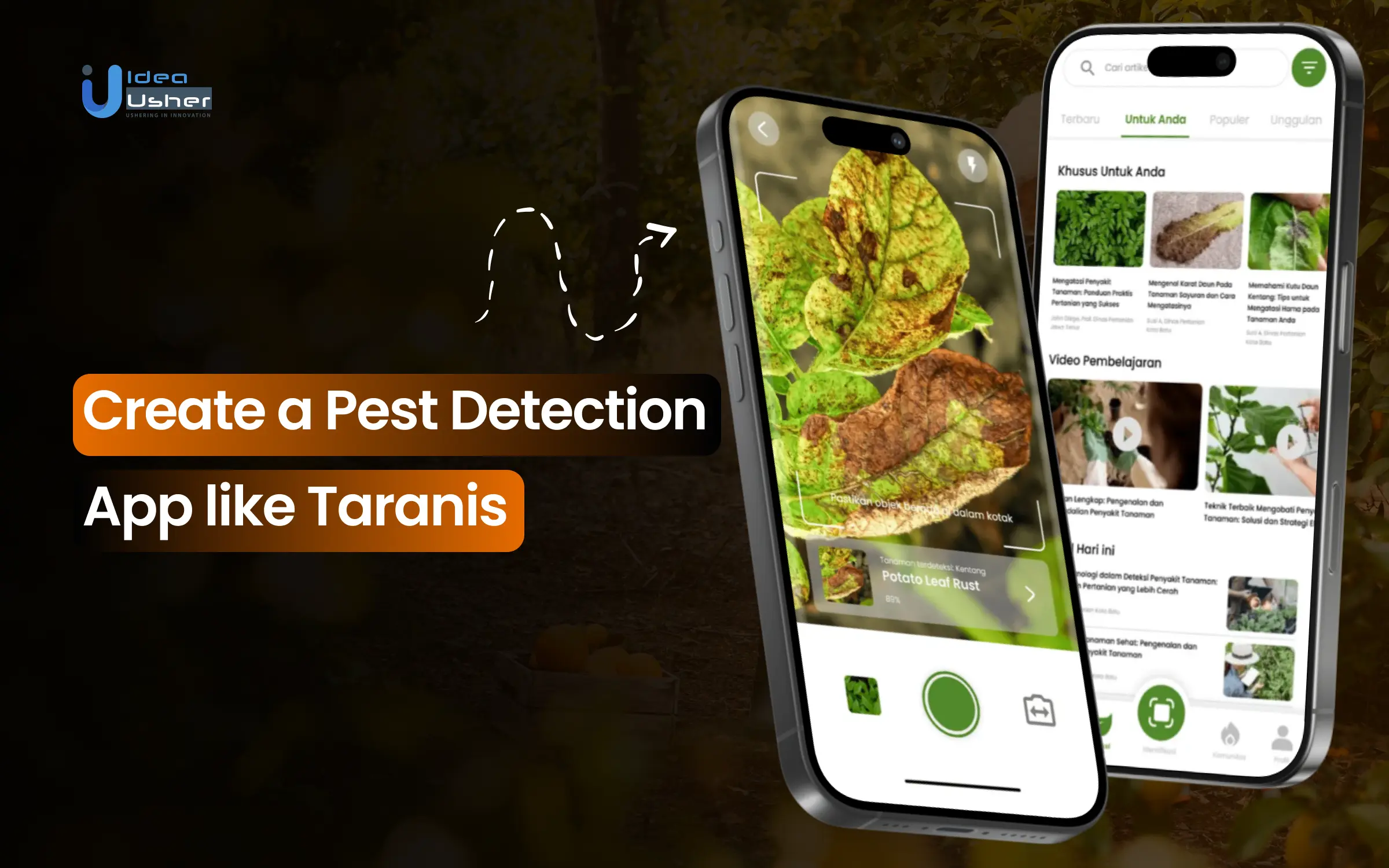
How Does the Taranis App Works?
In today’s agricultural world, the race for higher yields and better crop health isn’t just about soil and seeds; it’s driven by data. Taranis has become a leader in agricultural technology by offering a platform that turns raw data into meaningful insights. But what sets Taranis apart is not just the technology it uses, it’s how it integrates each layer to create a precision tool for farmers. Let’s break down the core mechanics behind the Taranis platform and understand how it works.
1. The Foundation: Ultra-High-Resolution Data Acquisition
The bedrock of Taranis’s success lies in the quality and precision of its data collection process. Unlike typical agricultural tools that rely on satellite imagery or mobile snapshots, Taranis uses cutting-edge aerial technology.
- Aerial Intelligence: Taranis operates a fleet of drones and planes equipped with high-resolution cameras and sensors. These devices capture imagery with such clarity that each pixel is capable of revealing minute details, often down to the sub-millimeter level.
- The “Leaf-Level” Advantage: This extreme level of resolution means that Taranis can detect threats on individual plants before they’re visible to the naked eye. It can spot early signs of insect eggs, fungal infections, and nutrient deficiencies, critical indicators that often go unnoticed until they’ve spread significantly.
2. The Brain: AI-Powered Analysis and a Massive Dataset
Once the data is captured, it’s the power of artificial intelligence (AI) that makes Taranis truly shine. The system doesn’t just present raw images—it analyzes them and provides actionable insights.
Proprietary AI Models
The imagery is processed by AI algorithms designed for deep learning and object detection. These models can differentiate between various plant issues with incredible accuracy, from insect infestations to disease outbreaks.
The Data Advantage
Taranis’s AI is built on a massive, continually expanding library of over 500 million analyzed images. This allows it to recognize patterns and threats with a high degree of confidence and precision. Its extensive database enables accurate identification of specific pests, diseases, and nutrient imbalances across crops.
Multi-Layered Data Fusion
The analysis doesn’t rely solely on imagery. Taranis combines aerial imagery with multiple data layers:
- Satellite Data offers a broad overview of field health, capturing trends over time.
- Weather Data helps put the imagery into context, such as identifying conditions conducive to disease outbreaks.
- Field Records & Soil Data enrich the analysis with unique details about the specific conditions of each field.
3. The Output: From Diagnosis to Prescription
Taranis doesn’t stop at identifying problems, it offers precise, actionable recommendations that empower farmers to act swiftly.
Precise Problem Identification
The platform generates easy-to-read maps and reports that clearly pinpoint issues. For example, it might identify “Western Corn Rootworm larvae in Zone B, pressure level 3.” This granularity ensures that farmers know exactly where to focus their efforts.
Actionable Recommendations
Beyond diagnosing problems, Taranis provides agronomic advice tailored to the situation. It can recommend the optimal product, application rate, and timing for the intervention, ensuring that resources are used efficiently and effectively. This targeted approach saves time, money, and minimizes environmental impact.
The Ag Assistant™
A standout feature of Taranis is its generative AI tool, the Ag Assistant. This tool allows users to ask natural language questions, like “Why is there yellowing in the northeast corner?” The Ag Assistant then processes the available data to provide immediate, data-driven answers, streamlining decision-making and enhancing productivity.
4. The Integration: Closing the Loop with Action
The final step in the process is turning insights into actions on the ground. This is where Taranis excels by providing seamless integration with farm equipment and workflows.
- Prescription Files: Taranis can generate variable rate prescription (VRA) files, which can be directly uploaded into modern farm machinery. This means that farmers can apply inputs (like fertilizers or pesticides) with pinpoint precision, avoiding waste and ensuring that each part of the field gets exactly what it needs.
- End-to-End Service: For many users, Taranis isn’t just a software tool—it’s a comprehensive service. From flight planning to data collection, analysis, and reporting, Taranis offers a fully managed service, either through the company or its partners. This end-to-end solution takes the burden off farmers, ensuring that they receive not just insights but the support to act on them.
Benefits of Pest Detection Apps
Pest detection apps offer farmers the ability to catch problems early, reducing crop loss and input costs. They make field management smarter by using real-time data to guide decisions, so you’re never left guessing. With targeted interventions, these apps help protect your yield while minimizing waste and resource use.
Technical Advantages: The Engine of Intelligence
1. Early and Accurate Detection
AI-powered pest detection apps use ultra-high-resolution imagery from drones or satellites, helping identify pests and diseases at the leaf level before visible damage occurs. This early detection allows farmers to take timely action, preventing infestations and minimizing crop loss.
2. Real-time Data Fusion
These platforms integrate multiple data streams like imagery, IoT sensor data, and weather forecasts in real time. This enables the AI to provide context-rich insights, allowing farmers to understand pest issues in relation to environmental factors like soil moisture, temperature, and crop stage.
3. Prescriptive Recommendations
Beyond detection, the app offers prescriptive recommendations for action, such as which products to apply and at what rate. Precision application maps help farmers target treatments exactly where needed, improving efficiency and reducing waste.
Business Advantages: Building a Market-Leading Platform
1. Recurring Revenue Models
By adopting a SaaS model, businesses can generate predictable, recurring revenue. Offering tiered subscriptions for growers and white-label solutions creates lasting customer relationships and scalable growth opportunities.
2. Scalability Across Geographies
The platform’s cloud-based infrastructure and adaptable AI models allow for easy expansion across regions and crop types. This scalability increases the total addressable market and enables the platform to grow seamlessly into new agricultural areas.
3. Sustainability and Compliance
The app helps reduce pesticide use by enabling precision application, aligning with sustainability goals. This contributes to improved ESG metrics, helping farmers meet regulations and appeal to eco-conscious consumers.
4. Investor Attraction
Sophisticated pest detection apps provide clear ROI by showing measurable results like yield preservation and reduced input costs. This makes the platform attractive to investors, offering a strong value proposition for further growth and innovation.
How to Develop a Pest Detection App like Taranis?
We specialize in developing advanced pest detection apps like Taranis for our clients, integrating cutting-edge technologies such as AI, IoT, and data fusion to create powerful, precision-based solutions for the agricultural industry.
Our process ensures that farmers can efficiently monitor and protect their crops, ultimately improving yields and reducing pesticide usage. Here’s how we build these innovative platforms for our clients:
1. Acquire High-Resolution Crop Imagery
We begin by sourcing high-resolution crop imagery through drones, planes, or satellites capable of capturing sub-millimeter details. Our team designs image pipelines tailored to detect even the smallest signs of damage caused by pests, ensuring that the system can identify issues at the earliest stage possible.
2. AI Models for Pest Recognition
Next, we train AI models using extensive, annotated datasets filled with millions of leaf-level images. These models are designed to identify a wide range of pest species, as well as detect nutrient deficiencies and crop-specific diseases, providing farmers with accurate and real-time insights into their crops’ health.
3. Build Data Fusion Architecture
To offer a comprehensive view of farm conditions, we create a robust data fusion architecture that combines imagery, weather data, IoT sensor inputs, and historical records. This system is designed to handle multi-modal data streams and deliver actionable insights, helping farmers make informed decisions.
4. Prescriptive Analytics Framework
We take pest detection a step further by developing prescriptive analytics algorithms. These algorithms not only detect problems but also provide actionable recommendations, such as where to apply pesticides. We integrate these recommendations with machinery systems to enable precision spraying, ensuring optimal resource use and minimal waste.
5. Offline and Edge Processing
Recognizing that many farms are in rural areas with limited connectivity, we ensure that the app can work offline. By leveraging edge AI, we enable real-time data processing directly in the field, providing faster alerts and recommendations without the need for constant internet access.
6. Continuous Feedback Loop
To enhance the app’s accuracy over time, we implement a continuous feedback loop. Agronomists can easily validate and adjust the AI’s predictions via intuitive user interfaces, with corrections fed back into the system to refine the model and improve its precision with each use.
Crafting AI for the Unpredictable World of Agriculture
Anyone can train an AI model to reach 99% accuracy with a perfectly clean, curated dataset in a controlled setting. But agriculture doesn’t operate in a lab. It’s shaped by the relentless heat of midday sun, the howling winds, and the cool, damp mornings. The light shifts constantly, dust coats everything, and each field has its own quirks.
This is where most apps fail. They treat farming as a simple, standardized problem. We view it as a dynamic, unpredictable system that demands a more resilient approach.
Here’s how we ensure our AI doesn’t just look good on a PowerPoint slide but thrives in the real world, on a dusty field at 3 PM.
1. We Feed Our AI a “Worldly” Education
AI accuracy hinges on the quality of the data it’s trained on. If you train it only on pristine, studio-quality images of leaves, it will struggle when the light is different or when dust clouds the view.
Our Training Library is Built on Chaos: We’ve deliberately exposed our models to millions of images captured in all sorts of real-world conditions—blazing noon light, soft evening glows, hazy skies, and even images covered in a thin layer of dust. We’ve included every plant growth stage, from cotyledon to senescence, and accounted for dozens of soil types that alter leaf color.
It’s Seen It All Before: This means our system isn’t thrown off by less-than-ideal conditions. When it encounters an image under harsh lighting or dust, it recognizes the patterns because it’s been trained with similar data. We don’t expect perfection from the field; we’ve built our technology to embrace the reality of farming.
2. We Don’t Rely on a Single Snapshot
One image isn’t enough. A yellow leaf could point to nitrogen deficiency, water stress, or simply be the result of a passing cloud’s shadow. We eliminate the guesswork by layering multiple data points, giving our AI the broader context a simple camera app can’t provide.
The Multi-Angle View: Our drone-based system captures images from multiple angles and lighting conditions. This helps the AI build a more accurate 3D understanding of the plant structure, distinguishing between actual disease and just a trick of the light.
The Data Cross-Check: An image is just one part of the puzzle. Our AI cross-references what it sees with other data, similar to systems like Taranis’s AcreForward™ Insights. Here’s how it works:
- It checks whether the soil moisture sensor in that zone is showing signs of stress.
- It consults the historical yield data to see if this area has been a persistent problem.
- It analyzes local weather conditions to determine if the environment is ripe for certain diseases.
- It compares the plant’s color and structure against what’s expected for its specific seed variety and growth stage.
Instead of just identifying a symptom, the AI builds a case, cross-checking all available evidence. This ensures a more reliable diagnosis and cuts down on false positives.
3. We Built a Self-Healing System
AI can’t afford to be static. Pests evolve, diseases shift, and farming practices change. We’ve designed our system to learn and adapt continuously, inspired by the best self-improving platforms.
The Ground-Truth Loop: Each time a farmer or agronomist validates or corrects the AI’s diagnosis, that information is fed back into the system. Like Taranis’s AI Core, this feedback loop is crucial to our system’s ability to evolve.
It Gets Smarter Every Day: This means our platform is always learning and improving. If a new rust strain appears in Nebraska, the system learns to identify it more quickly and accurately. The AI evolves with each new acre scouted, becoming smarter with every new interaction, creating a collective intelligence that benefits all users.
Tools & APIs Needed for a Pest Detection App
Building an AI-driven pest detection app is like constructing a high-performance engine—every part has to work perfectly together. At IdeaUsher, we focus on creating a seamless, powerful solution for modern farming. Here’s a quick look at the essential tools and technologies that make our platform run smoothly.
1. AI & ML Frameworks
The AI model is the heart of the system, transforming raw images into actionable insights. We use the most advanced frameworks to train models that are both accurate and scalable.
- TensorFlow & PyTorch: Key frameworks for building AI models. PyTorch is great for rapid prototyping, while TensorFlow is ideal for scaling models with tools like TensorFlow Lite.
- Keras: A high-level API on TensorFlow that simplifies deep learning model prototyping, helping us efficiently fine-tune pest detection models.
2. Image Processing Tools
Before AI can make any predictions, the image data must be processed and enhanced. This is where advanced computer vision tools come in.
- OpenCV: We use OpenCV for essential pre-processing tasks such as resizing images, reducing noise, color correction, and segmentation. This ensures that the data fed into the AI model is clean, consistent, and optimized for analysis—whether the data comes from drones, satellites, or smartphones.
- YOLOv8 (You Only Look Once): For real-time detection, we use YOLOv8, a highly efficient object detection model. YOLOv8 processes images in milliseconds and can detect multiple pests in a single frame, allowing us to offer a fast and responsive user experience.
3. Data Integration APIs
To make the app truly intelligent, it needs real-world data. We integrate various APIs that provide critical contextual information, enriching our AI models’ predictions.
| Technology | Purpose |
| Drone APIs (e.g., DJI SDK) | Automates data collection, programs flight paths, and captures images, integrating aerial imagery into the platform. |
| Satellite Imagery APIs (e.g., Planet Labs, Sentinel Hub) | Provides macro-level crop health data through daily Earth scans, identifying large-scale stress zones before closer drone inspection. |
| Weather APIs (e.g., OpenWeatherMap, Weatherstack) | Integrates hyper-local weather data to correlate pest activity with conditions like humidity, temperature, and rainfall for improved risk assessment. |
| IoT Platforms (e.g., AWS IoT Core, Azure IoT Hub) | Collects and manages ground-level sensor data (e.g., soil moisture, temperature) to enhance pest detection accuracy. |
4. Backend & Cloud Platforms
To power our AI models and process massive datasets, we rely on scalable cloud platforms like AWS, GCP, and Azure. These platforms provide high-performance storage and computing power, plus managed services like AWS SageMaker and Google Vertex AI to streamline the machine learning process.
For storing and querying field data, we use cloud databases like Google BigQuery and Amazon RDS, making it easy to track trends and optimize decisions.
5. Edge Computing Solutions
For real-time analysis in remote fields, we use edge computing devices like NVIDIA Jetson. These compact AI computers, powered by TensorRT, allow for immediate, high-performance insights right in the field. This means farmers can get real-time results without relying on a stable internet connection.
Use Case: Precision Pest Management
One of our clients, a large rice growers’ cooperative, came to us struggling with stem borers, pests that often went unnoticed until they caused significant damage. Their traditional spray method was ineffective and unsustainable, covering thousands of acres the same way. They needed more than just an app; they needed a field intelligence system to make informed, targeted decisions.
Our Approach: Listening to the Land (and the Growers)
Rather than jumping straight into development, we took the time to understand the situation from the ground up. We walked the fields with the cooperative’s agronomists to gain a clear picture of the challenge. We realized that technology alone wouldn’t solve the problem; we needed to ensure that the digital solution matched the reality of their crops.

The Eagle-Eye View
We used a mix of high-resolution drones and satellites to tackle the stem borer issue. The drones pinpointed problem areas with millimeter-level precision, while the satellites gave us a complete view of the co-op’s fields. Our AI was trained not just to spot visible damage, but also to catch subtle signs of infestation before they were even noticeable.
Connecting the Dots
Data alone doesn’t tell the full story, so we integrated the co-op’s soil moisture sensors and weather station data into our system. This helped us cross-check pest hotspots with environmental factors, like water stress, to get a clearer picture. The platform learned to make these distinctions, giving farmers insights that were right for their specific conditions.
From “What’s Wrong” to “Here’s How to Fix It”
The real value kicked in when the system didn’t just spot problems but provided real solutions. Instead of just marking pest areas, the app generated a detailed action plan, telling farmers exactly which fields to treat, what controls to use, and how much pesticide was needed. It even created files for precision spraying, ensuring targeted, efficient pest management.
The Result: Measured in More Than Just Profit
The results were remarkable and far-reaching.
- For the Land: The cooperative cut pesticide use by 30% in the first season, reducing environmental impact and helping beneficial insects thrive, creating a healthier ecosystem.
- For the Bottom Line: By protecting premium rice from loss, they boosted yields and reduced costs, leading to higher profit margins. Meeting sustainability standards also helped secure more lucrative export contracts.
- For Their Peace of Mind: The growers shifted from reactive to proactive management, with the app providing a clear, daily action plan for crop protection, easing their worries and transforming their approach to farming.
Conclusion
Pest detection apps are revolutionizing AgriTech by harnessing the power of AI, IoT, and aerial imagery to offer precise, real-time insights for farmers. For businesses, this isn’t just about improving agricultural practices—it’s about creating scalable, sustainable SaaS solutions that drive recurring revenue. At Idea Usher, we empower enterprises to build and integrate these cutting-edge platforms, guiding them through every step from data fusion to AI model training and deployment, ensuring seamless, high-impact solutions.
Looking to Develop a Pest Detection App like Taranis?
At Idea Usher, we don’t just develop apps; we create powerful, market-leading solutions. Our goal is to help you build a Taranis-like platform that goes beyond basic pest detection to deliver AI-driven insights that protect crops, reduce costs, and drive recurring revenue.
Why Build with Us?
- Deep AgTech Expertise: We build apps that understand the entire farming process, from soil to sale.
- Top-Tier Technical Talent: With over 500,000 hours of coding experience, our team of ex-MAANG/FAANG developers delivers secure, scalable platforms.
- From Concept to Growth: We’re with you every step of the way, from initial vision and AI training to deployment and scaling.
Don’t just detect, decide. Let’s create the intelligence that will shape the future of farming.


FAQs
A1: Pest detection apps are especially valuable for high value crops such as corn, soybeans, cotton, and fruits. These crops are more vulnerable to pest damage, and early detection helps farmers safeguard their yield, leading to better returns and more efficient resource management.
A2: The cost to develop a pest detection app like Taranis varies widely depending on factors such as the complexity of the app, the type of datasets, and the AI integration needed. Developing a robust, feature-rich app can require a significant investment in both time and resources.
A3: Farmers do not always need drones to use pest detection apps. These apps can integrate with third-party drone providers, or they can rely on other data sources such as satellite imagery and IoT sensors, making them accessible to a wide range of users.
A4: Yes, pest detection apps can function offline by using edge computing. This allows the app to process data locally on devices without needing constant internet access, ensuring pest monitoring can continue even in areas with limited connectivity.


