These days, people are increasingly drawn to the outdoors, seeking adventure and connection with nature. Rivers, with their scenic beauty and recreational opportunities, offer a perfect escape. However, navigating rivers can be unpredictable, especially during changing weather conditions. That’s where river forecasting apps come into play, providing essential information to ensure a safe and enjoyable experience. They provide vital information such as water levels, flow rates, and potential hazards like flooding or debris. This knowledge is crucial for recreational activities like kayaking or fishing, as well as for professional purposes like transportation, agriculture, and emergency management.
The river forecasting app market is expected to reach around $359.5 million by 2031, growing at a steady 6.2% annual rate from 2021 to 2031. More people are using these apps to enhance their river adventures, making now the perfect time for businesses to jump in and take advantage of this rising demand!
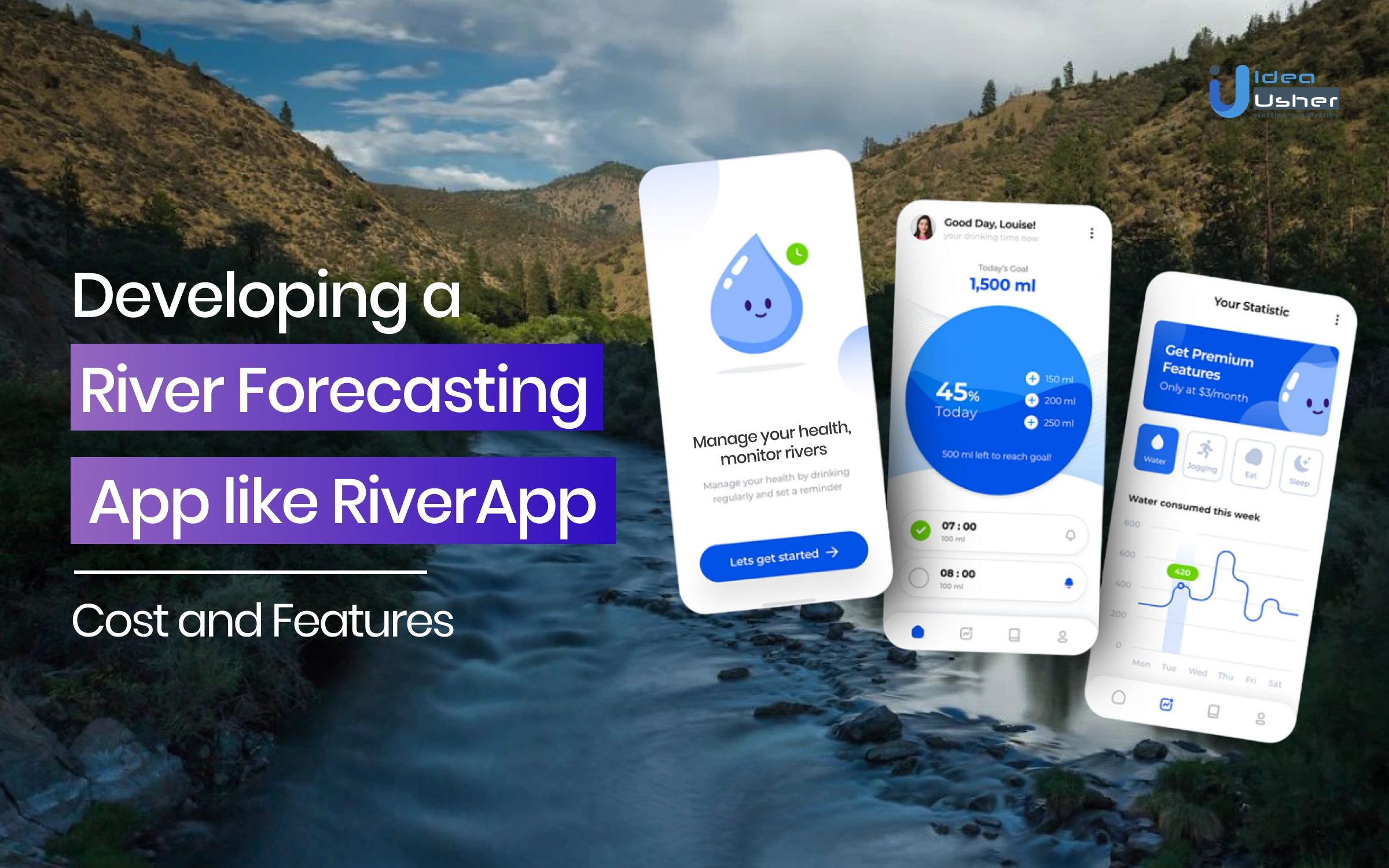
With these trends, many river forecasting apps are making their way into the U.S. market. In this guide, we’ll show you how to create a user-friendly river forecasting app like RiverApp, packed with great features to help your app stand out. Let’s dive in and show you how to build something truly unique!
Key Market Takeaways for River Forecasting Apps
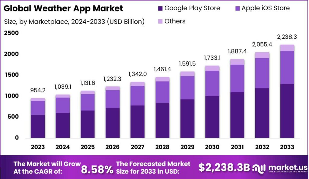
Source: Market.US
This expansion is driven by increasing demand for precise and timely hydrological data, especially as climate change leads to more frequent and intense flooding across the United States. Farmers, water managers, and outdoor enthusiasts are relying on these apps for accurate monitoring of river conditions, allowing them to make informed decisions about water management and safety.
A standout example in this market is RiverApp, which offers real-time data on water levels and flows for over 15,000 rivers in the U.S. and worldwide. This app is a valuable tool for outdoor activities like kayaking and fishing, providing features such as personalized alerts for specific hydrometric stations and detailed maps of river conditions. Another key player is the CHPS developed by the NOAA. CHPS uses advanced modeling to generate forecasts for rivers across the country, aiding flood warnings and improving public safety.


Business Model of the RiverApp
RiverApp, a popular river forecasting app, has been in operation for over 10 years and serves as a vital resource for checking water levels across more than 10,000 rivers globally. It is utilized in over 20 countries, including regions in North America, Europe, Australia, and New Zealand. The app boasts approximately 30,000 daily users, making it a significant player in the outdoor recreation sector.
Advertising Revenue
RiverApp generates revenue primarily through advertising. The advertising strategy includes:
- Targeted Native Ads: Advertisements are integrated into the river pages of the app. Advertisers can select specific rivers or regions where their ads will appear, allowing for targeted marketing to local kayaking schools or international brands.
- Ad Format: Ads include images, titles, and subtitles available in multiple languages. This design ensures that ads blend seamlessly with the app’s content.
- Performance Tracking: Advertisers have access to reporting tools that allow them to monitor user interactions with their ads.
User Base
The app’s user base comprises various outdoor enthusiasts:
- Kayakers: The primary audience utilizes the app to check river conditions before embarking on trips.
- Fishermen and Other River Users: These users benefit from real-time data for recreational activities on rivers.
RiverApp encourages user engagement by allowing paddlers to share information about river conditions. This community-driven aspect enhances the app’s value proposition by providing real-time updates on hazards and conditions directly from users.
Are River Forecasting Apps like RiverApp Profitable?
River forecasting apps like RiverApp can be profitable by providing valuable information to users and generating revenue through various monetization strategies. Here are some key factors to consider:
Customer Lifetime Value
The customer lifetime value for river forecasting apps depends on factors such as user engagement, retention rate, and revenue per user. Apps that provide accurate, real-time river level forecasts and alerts can have a high CLV if users find the information essential for their activities, such as:
- Recreational activities like fishing, boating, and kayaking
- Commercial activities like hydropower generation, irrigation, and navigation
- Flood preparedness and emergency response
Monetization Strategies
River forecasting apps can generate revenue through various monetization strategies, such as:
- Subscription fees: Offering premium features or ad-free experiences for a monthly or annual subscription fee.
- In-app purchases: Selling additional features, data, or customization options within the app.
- Advertising: Displaying targeted ads within the app, which can be more effective if the app provides location-specific forecasts.
- Data licensing: Selling aggregated, anonymized user data to third parties for market research or other purposes.
Potential Revenue from River Forecasting Apps
River forecasting apps are essential tools for various users, including outdoor enthusiasts, emergency responders, and water resource managers. Their profitability largely hinges on user engagement, subscription models, and the specific features they offer. Here, we explore some prominent river forecasting apps and provide calculated predictions for their potential revenue.
RiverApp
RiverApp is a leading application that provides real-time data from over 40,000 hydrometric stations worldwide. It offers both free and premium features, with the premium subscription priced at approximately $7.99 per year or $1.29 per month. If RiverApp successfully attracts 10,000 paying subscribers at the annual rate of $7.99, it could generate around $79,900 annually.
BWI Earth
Another noteworthy example is BWI, which specializes in forecasting services tailored for hydropower plants. If BWI charges $1,000 per month for its services and secures contracts with 50 hydropower plants, it could potentially generate $600,000 annually. This model highlights the lucrative nature of specialized forecasting services in sectors that rely heavily on accurate data for operational efficiency.
NRCS Water Supply Forecasts
The NRCS in the U.S. provides water supply forecasts that are crucial for agricultural planning and water resource management. While NRCS does not operate as a commercial app, its forecasts create an estimated public benefit exceeding $100 million annually in just one river basin by optimizing water usage for agriculture and other sectors.
Key Features of River Forecasting Apps like RiverApp
Here are some key features of river forecasting apps,
1. Real-time River Data
Accessing current water levels flows, and temperatures for thousands of rivers worldwide is crucial for businesses and individuals alike. This real-time information allows companies involved in water management, recreation, and logistics to optimize their operations and ensure safety for their customers.
2. Interactive River Maps
Visualizing river locations, gauging stations, and whitewater runs on interactive maps empowers users to gain a deeper understanding of the river they’re interested in. This can be really valuable for companies in the tourism industry, helping them design safe and exciting river adventures for their clients.
3. Favorites and Alerts
Saving favorite rivers for quick access and setting up alerts for specific water levels are features that enhance user experience and promote app loyalty. Businesses can leverage this by offering location-based services or targeted promotions to users who frequent particular rivers.
4. Whitewater Information
For companies catering to whitewater enthusiasts, providing detailed information on whitewater courses, difficulty levels, and put-in/take-out points is a significant advantage.
5. Enhanced Maps for Deeper Insights
While basic maps provide a good overview, some apps offer more detailed and interactive maps with additional features in premium versions. These features can include historical data overlays, water quality information, and even integration with weather forecasting apps.
Features that Can Enhance River Forecasting Apps like RiverApp
River forecasting apps like RiverApp play a vital role in supporting businesses and individuals who rely on waterways. By incorporating innovative features, these apps can further enhance their value and drive user engagement. Here are some innovative features to consider:
1. Integration with Hydrological Modeling Tools
Connecting with hydrological modeling tools can provide more accurate and detailed predictions of river flows, water levels, and potential flooding. This is especially beneficial for businesses like water management agencies and infrastructure developers.
2. Sediment Load Monitoring
Incorporating data on sediment load can help businesses like navigation companies and fisheries understand the impact of sedimentation on waterways. This information can be used to improve navigation safety and protect aquatic ecosystems.
3. Integration with Aquatic Ecosystem Monitoring
Connecting with aquatic ecosystem monitoring data can provide insights into the health of river ecosystems. This is valuable for businesses like environmental consultancies and conservation organizations.
4. Integration with Dam and Weir Operations Data
Linking with data from dams and weirs can help businesses like hydropower plants and irrigation systems optimize their operations based on river conditions.
5. Integration with Flood Warning Systems
Connecting with flood warning systems can provide early alerts to businesses and communities at risk of flooding. This can help minimize damage and protect lives.
6. Integration with River Tourism and Recreation Data
Incorporating data on river tourism and recreation activities can help businesses in the tourism industry, such as rafting outfitters and hotels, better understand demand and tailor their offerings.
7. Integration with Water Quality Monitoring Networks
Connecting with water quality monitoring networks enables access to real-time data on key parameters like pH and nutrient levels. This information is crucial for businesses such as fisheries and water treatment facilities.
How Will the River Monitoring System Work in an App?
River monitoring systems, such as those implemented in applications like RiverApp, leverage advanced IoT technologies to provide accurate and real-time data on river conditions. These systems utilize various sensors to measure critical parameters such as river levels, flow rates, and temperatures.
Here are the key sensors used in river monitoring,
Ultrasonic Sensors:
- Emit high-frequency sound waves toward the water’s surface.
- Measure the distance to the water surface based on the time it takes for the sound waves to return.
- Ideal for continuous monitoring of water depth.
Doppler Radar Sensors:
- Use the Doppler effect to gauge river velocity by observing shifts in the frequency of reflected waves due to the movement of water.
- It can be mounted above the river for real-time velocity measurements.
Pressure Transducers:
- Determines the pressure exerted by the water column above, which corresponds to the water level.
- Often used in conjunction with other sensors for comprehensive monitoring.
These sensors are typically installed on structures like bridges or poles along the riverbank, ensuring continuous data collection that is transmitted wirelessly to a central gateway for processing.
Data Processing and Cloud Integration
The data collected from these sensors is processed and stored on a cloud-based platform. This allows users to access real-time updates about river conditions through mobile applications like RiverApp. Key features include:
- Real-Time Alerts: Users can set notifications for specific thresholds (e.g., alerts when water levels exceed 3 meters).
- Historical Data Analytics: Users can visualize trends over time, aiding in flood preparedness and recreational planning.
- Digital Twins: Sensor data can create virtual models of river systems, integrating additional environmental data from sources like weather stations and soil moisture sensors.
Development Steps for a River Forecasting App like RiverApp
Developing a river forecasting app like RiverApp requires a unique blend of technical expertise, data science, and domain knowledge. Here are the key steps involved:
1. Data Acquisition and Processing
Businesses must first identify data sources. Historical and real-time data are gathered from various reliable sources, including government agencies, meteorological services, and hydrological stations. This data is crucial for building accurate forecasts.
2. Model Selection and Training
Selecting the right machine learning models is essential. For river forecasting, algorithms such as ARIMA, LSTM, or Prophet are often suitable due to their strength in time series forecasting. Once the models are chosen, companies must train them on historical data, establishing patterns and trends necessary for future predictions.
3. Model Evaluation and Validation
Model evaluation is an important step for businesses to ensure the accuracy of their app. Metrics such as MSE, RMSE, and MAE are used to measure performance. Cross-validation is applied to test the model’s generalization capability on unseen data.
4. Real-time Data Integration and Quality Control
For an effective river forecasting app, real-time data must be integrated through robust ingestion pipelines. This allows businesses to gather real-time data from various sources like sensors, gauges, and satellite imagery.
5. Forecasting and Prediction
Once the models are trained, they are applied to real-time data to generate forecasts for river levels, flows, and other key parameters. Businesses must also incorporate uncertainty quantification to provide reliable estimates that help users make informed decisions.
6. Create Alert Systems and Notifications
Setting up alert thresholds is crucial for notifying users of critical conditions like flooding or low water levels. Businesses can define these thresholds based on river conditions and implement notification systems to alert stakeholders, including government agencies and local communities.
7. Integration with Meteorological Data
Finally, integrating meteorological data is key to enhancing the accuracy of forecasts. Weather data such as precipitation, temperature, and wind speed should be connected with the forecasting system. Atmospheric conditions, especially storms and droughts, should also be accounted for as they significantly impact river flows.
Cost of Developing a River Forecasting App like RiverApp
| Component | Description | Sub-Components | Estimated Cost Range |
| 1. Research & Data Acquisition | Identifying and integrating data from agencies, weather services, and stations. | Data sourcing, cleaning, and processing | $3,000 – $10,000 |
| Data Sources: Acquiring hydrological data from various sources. | $1,000 – $4,000 | ||
| Data Cleaning: Organizing and transforming raw data into usable formats. | $2,000 – $6,000 | ||
| 2. Front-End Development | Developing user interfaces for mobile and web platforms. | UI design, mobile/web app development | $10,000 – $30,000 |
| UI Design: Creating intuitive and user-friendly interfaces. | $4,000 – $10,000 | ||
| Mobile App Development: Building native iOS and Android apps. | $3,000 – $10,000 | ||
| Web App Development: Developing a web-based platform for desktop users. | $3,000 – $10,000 | ||
| 3. Backend Development | Setting up infrastructure, databases, and APIs for data handling. | Server setup, database design, API development | $10,000 – $30,000 |
| Server Infrastructure: Hosting and managing backend processes. | $3,000 – $10,000 | ||
| Database Design: Storing water levels, user data, and alerts. | $2,000 – $8,000 | ||
| API Development: Enabling communication between the frontend and backend. | $5,000 – $12,000 | ||
| 4. App Features | Developing key features such as water level monitoring and flood alerts. | Real-time monitoring, alerts, weather integration | $10,000 – $25,000 |
| Water Level Monitoring: Displaying real-time river conditions. | $5,000 – $10,000 | ||
| Flood Alerts: Providing notifications for potential flood risks. | $2,000 – $5,000 | ||
| Weather Forecasts: Integrating weather data into river forecasts. | $3,000 – $5,000 | ||
| 5. Testing & Quality Assurance | Ensuring functionality, performance, and security of the app. | Functional, performance, and security testing | $3,000 – $7,000 |
| Functional Testing: Verifying all app features work correctly. | $1,000 – $3,000 | ||
| Performance Testing: Checking speed and responsiveness. | $1,000 – $2,000 | ||
| Security Testing: Ensuring data privacy and app security. | $1,000 – $2,000 | ||
| 6. UI/UX Refinement | Improving the design and usability based on testing feedback. | Iterative refinement of UI/UX | $3,000 – $8,000 |
| UI Refinement: Adjusting interface design based on user feedback. | $1,000 – $4,000 | ||
| UX Refinement: Enhancing user experience and navigation. | $2,000 – $4,000 |
Total Estimated Cost: $10,000 – $100,000
The development cost of a river forecasting app can vary significantly depending on several factors. While some factors are common to most app development projects, others are unique to the specific requirements of a river forecasting app.
Data Acquisition and Processing
River forecasting apps require extensive hydrological data, such as water levels, flow rates, precipitation, and soil moisture. The process of acquiring, cleaning, and processing this data can be complex and time-consuming, adding to the development cost.
Real-time Data Integration
River forecasting apps rely on real-time data to provide accurate and timely information. Integrating data from sensors and monitoring stations requires specialized hardware and software, as well as robust communication infrastructure. This can increase the complexity and cost of the development process.
Geographic Coverage
The geographic area that a river forecasting app covers will influence the amount of data required and the complexity of the algorithms used to analyze and forecast water levels. Apps covering large regions may need to incorporate data from multiple river basins and consider factors such as topography, land use, and climate variability.
Regulatory Compliance
River forecasting apps should comply with various regulations and standards related to security and environmental protection. These requirements can add to the development cost and complexity, as businesses must ensure that their apps adhere to applicable laws and regulations.
Tech Stacks Required to Develop a River Forecasting App like RiverApp
Developing a forecasting app like RiverApp requires a well-structured technology stack that encompasses various components, from front-end design to data analysis. Companies and businesses involved in this domain must consider several critical elements to ensure the app’s effectiveness and usability.
1. Front-End Development
Creating an intuitive interface is paramount. The layout should be easy to understand, catering to users with varying technical backgrounds. Effective visualizations, including charts, graphs, and maps, are essential for representing river data clearly and concisely.
2. Hydrometric Sensors
The integration of hydrometric sensors is vital for real-time data collection. Businesses should utilize various types of sensors, such as water level gauges, flow meters, temperature sensors, and turbidity meters. Technologies like ultrasonic, Doppler, and conductivity can be employed for accurate measurements.
3. Real-Time Data Transmission
Efficient real-time data transmission is crucial for maintaining accurate forecasts. Companies can utilize protocols like MQTT, Modbus, and HTTP to facilitate data transfer from sensors to the app.
4. Time-Series Databases
To handle hydrological data effectively, specialized time-series databases are necessary. Options such as InfluxDB and TimescaleDB provide the necessary structure for storing and querying time-sensitive data.
5. Hydrological Modeling Software
Incorporating hydrological modeling software is critical for river forecasting. Tools like HEC-HMS, MIKE SHE, and SWMM offer advanced modeling capabilities tailored to river systems.
6. Statistical Analysis and Machine Learning
For effective predictions of river levels and flows, businesses should leverage statistical analysis and machine learning techniques. Languages such as Python and R provide robust libraries, including Pandas, NumPy, Scikit-learn, and tidyverse, for data manipulation and analysis.
7. Geographic Information Systems Software
GIS software plays a significant role in visualizing river networks and related data. Tools like ArcGIS and QGIS enable businesses to create detailed maps and spatial analyses that provide insights into river systems.
Most Successful Business Models for River Forecasting Apps like RiverApp
Here are the most successful business models for river forecasting apps:
1. AI-Driven Flood Forecasting Platforms
AI-driven platforms, such as Google’s Flood Hub, utilize machine learning algorithms to provide accurate flood forecasts up to seven days in advance. This model combines hydrologic and inundation modeling to predict water levels and affected areas based on real-time data from various sources, including weather forecasts and satellite imagery.
- Coverage and Impact: The Flood Hub currently covers over 1,800 sites across 80 countries, providing critical information to approximately 460 million people.
- Financial Aspects: While the service is free for users, it is funded through partnerships with governments and NGOs. The model emphasizes public safety and disaster preparedness rather than direct revenue generation.
- Statistical Success: In 2022, Google expanded its forecasting capabilities significantly, sending out 800,000 alerts during severe weather events, demonstrating the model’s effectiveness in real-world applications.
2. Subscription-Based Water Quality Monitoring Services
Some river forecasting apps focus on water quality monitoring by providing real-time data on pollutants and other water quality indicators. These services often operate on a subscription basis for businesses and governmental agencies.
- Technology Utilization: For instance, a cloud-based system uses satellite data coupled with dynamic catchment-scale models to forecast water quality impairments like cyanobacteria blooms.
- Market Demand: With increasing concerns over water safety and environmental sustainability, demand for these services has grown. The market for water quality monitoring is expected to reach $4 billion by 2025, driven by regulatory requirements and public health concerns.
- User Base: The app can cater to recreational users, local governments, and industries relying on clean water, thus broadening its user base beyond just environmental agencies.
3. Integrated Agricultural Water Management Solutions
This model targets farmers and agricultural stakeholders by providing forecasts that help manage water resources effectively. These solutions often integrate snowpack data and climate models to predict river runoff.
- Economic Value: The NRCS in the U.S. estimates that improved forecasting can generate over $100 million annually in public benefits for a single river basin.
- User Benefits: Farmers rely on these forecasts to make informed decisions about crop planning and irrigation management, thus enhancing agricultural productivity.
- Technological Innovation: The NRCS has introduced an AI-based multi-model machine learning system that optimizes river prediction programs, showcasing a significant technological shift in agricultural water management.
4. Public Alert Systems for Emergency Management
Public alert systems integrated into river forecasting apps provide real-time alerts about potential flooding or hazardous water conditions. These systems are often linked with local emergency management agencies.
- Community Engagement: Apps like the Flood Hub not only provide forecasts but also facilitate community engagement by sharing alerts via social media platforms.
- Operational Efficiency: By improving the timeliness of warnings, these systems can significantly reduce fatalities during flooding events. For example, early warning systems have been shown to decrease flood-related deaths by up to 30% in some regions.
- Funding Models: Many of these services are funded through government grants or partnerships with NGOs focused on disaster risk reduction.
Conclusion
A river forecasting app can be very useful for people who live near or enjoy rivers. It can help them stay safe and plan their activities better. Businesses can also make money from this kind of app. By providing helpful information, they can attract more people to their brand. This can lead to more customers and money. Businesses can also work with government agencies to help people during emergencies.
Looking to Develop a River Forecasting App like RiverApp?
At Idea Usher, we can help you navigate the currents of the river forecasting app market. With over 500,000 hours of development experience in hydrological data modeling, real-time data stream integration, and user interface design, our team is equipped to build a robust and reliable river forecasting app. Let us leverage our expertise to create a solution that empowers users with accurate information on water levels, flow rates, and potential hazards, ensuring a safe and enjoyable experience on the water.
FAQs
Q1: How to make a river forecasting app?
A1: Creating a river forecasting app involves several key steps. First, you’ll need to gather and integrate data from various sources, including government agencies, weather stations, and hydrological models. This data can be used to create accurate forecasts for water levels, flow rates, and potential hazards. Next, you’ll need to develop a user-friendly interface that allows users to easily access and interpret the forecast information.
Q2: How does a river forecasting app work?
A2: River forecasting apps utilize a combination of real-time data and predictive modeling to provide accurate forecasts. They gather a lot of data from various sources, including weather stations, hydrological models, and government agencies, and use this information to create models that predict future river conditions. These models take into account factors such as rainfall, snowmelt, and historical data to provide users with timely and reliable information on water levels, flow rates, and potential hazards.
Q3: What are the features of a river forecasting app?
A3: River forecasting apps typically include features such as real-time water level data, flow rates, flood alerts, and historical data. Advanced features may include weather forecasts, debris flow warnings, and integration with government agencies for emergency response. Some apps also offer customizable alerts and notifications, allowing users to tailor the information they receive to their specific needs.
Q4: What is the cost of developing a river forecasting app?
A4: The cost of developing a river forecasting app can vary significantly depending on several factors, including the desired features, complexity of data integration, and geographic scope. While a basic app might be less expensive, more sophisticated features can increase the cost. Additionally, ongoing maintenance and updates are essential for ensuring the app’s accuracy and relevance, adding to the overall cost.